Situation Summary
Israel remains at global threat rank #3 (composite score 99) driven by active conflict across multiple fronts—Gaza, Lebanon border, and West Bank—with 427 tracked events recorded. The past 24–48 hours show sustained operational tempo: IDF pre-emptive strikes on Gaza rocket positions, attempted militant infiltration near the Kerem Shalom crossing, and elevated Hezbollah reorganization signals along the northern border. Trajectory indicates sustained kinetic activity and elevated readiness posture rather than de-escalation, despite nominal ceasefire frameworks.
Key Developments
- Bint Jbeil area, southern Lebanon (25 Jul): IDF canine unit encountered armed Hezbollah militant; combat dog killed, militant shot dead by IDF soldier during heightened border security operations.
- Gaza rocket intercept operations (24–25 Jul, overnight): IDF struck four rocket launch positions across Gaza Strip; strikes characterized as pre-emptive action against launchers prepared for Israeli targets. Multiple sources report dozens of targets hit in Khan Younis and surrounding areas.
- Kerem Shalom crossing, Gaza border (24–25 Jul): Two militants attempted to approach/penetrate crossing; one detained. IDF confirmed no infiltration into Israeli territory occurred; incident triggered alerts to nearby communities.
- Qalandiya checkpoint, north of Jerusalem (25 Jul): Border Police (Magav) officers opened fire on security guards who attacked them at key West Bank crossing; armed personnel engaged; no civilian casualties reported in initial assessment.
- Hatzerim airbase area, southern Gaza border (past 24–48 hrs): Palestinian Islamic Jihad militants suspected of recent rocket attack on Hatzerim killed in IDF strike; operation linked to ongoing counter-rocket campaign.
- Northern border readiness (24–25 Jul, general): Israeli security assessments report Hezbollah accelerating reorganization ahead of potential large-scale renewed fighting; IDF heightening preparations "for all scenarios" along Lebanese border.
- Gaza military infrastructure campaign (24–25 Jul, rolling): IDF daily operational tallies cite hundreds of Hamas targets struck in past 24 hours including tunnels, command centers, military compounds, observation posts; "dozens" of militants killed in most recent cycle.
Highest-Risk Areas
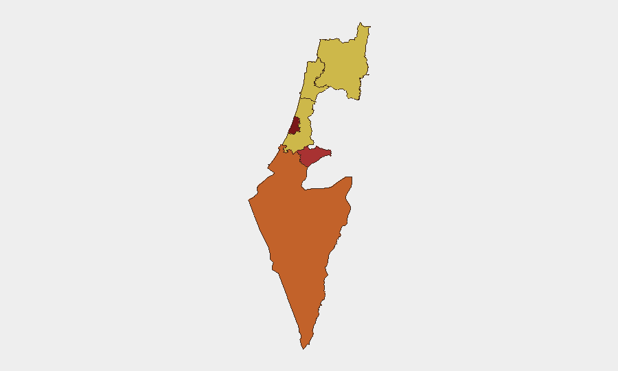
Tel-Aviv District (rank 99) and Jerusalem District (78.1) dominate the sub-national risk profile, reflecting concentration of national infrastructure, population density, and proximity to active operational theaters. South District (75.6) and North District (70.2) remain elevated due to direct exposure to Gaza and Lebanon border activity, respectively—including rocket/infiltration threats and IDF counter-operations. Center District (69.6) and Haifa (69) reflect secondary exposure to cross-border fire and infrastructure vulnerability; all rankings reflect sustained kinetic activity rather than isolated incidents.
How GeoBit Would Assist
Security teams protecting personnel or assets in Israel should employ AOI Monitoring & Early Warning on high-risk districts (Tel-Aviv, Jerusalem, South, North) to detect emerging attack patterns or operational shifts; Intel Sweep and OSINT fusion to track Hezbollah and Hamas reorganization signals; and Conflict & Military battle mapping with force-structure tracking to monitor IDF posture changes and cross-border readiness. Network & Actor Analysis of militant command-and-control messaging and Routing & Network Analysis for alternative travel corridors in West Bank and southern Israel would support duty-of-care and movement planning.
7-Day Outlook
Operational tempo is expected to remain elevated across all three fronts (Gaza, West Bank, Lebanon border) with sustained IDF counter-operations against rocket infrastructure and militant cells. No significant de-escalation signals are evident; northern border preparations and Gaza strike cycles suggest readiness for sustained or expanded conflict. Risk to international personnel and asset operations remains materially elevated, particularly in Tel-Aviv, Jerusalem, and South District corridors.
Highest-Risk Areas — Ranked
| # | State / Region | Risk |
|---|---|---|
| 1 | Tel-Aviv District | 99 |
| 2 | Jerusalem District | 78.1 |
| 3 | South District | 75.6 |
| 4 | North District | 70.2 |
| 5 | Center District | 69.6 |
| 6 | Haifa District | 69 |
Sources
Previous Daily Briefs
A new Israel brief is written every day — each with its own risk map and downloadable CSV. Here's the last week; use the calendar to go further back.
📅 Browse every day by calendar →
Highlighted days have a brief. Tap a day for that day's map & analysis, or “csv” for that day's dataset ($5).
Atlas — our AI intelligence desk — emails them this snapshot personally. Nothing else, no list.