Situation Summary
Lebanon faces escalating military tension along its southern border, with Israeli forces conducting repeated cross-border airstrikes and artillery activity despite active ceasefire negotiations and Lebanese Army deployment into pilot security zones. The Lebanese military has begun formal security operations in southern villages under a U.S.-backed framework, but Israeli forces have fired warning shots near Lebanese troops and continued offensive operations, creating friction that threatens implementation. Beirut Governorate remains the highest-risk zone (90.2 composite score), while southern regions—Nabatieh and South Governorate—are experiencing active military operations with significant IED and small-arms hazards to personnel.
Key Developments
- Froun, South Lebanon — 20 Jul 2026: Lebanese Armed Forces launched formal security operations in this village as the first "pilot zone" under the ceasefire framework, marking the initial phase of military redeployment.
- Srifa & Zawtar al-Gharbiya, South Lebanon — 20 Jul 2026: Lebanese Army deployed to both villages as part of the same pilot-zone rollout, extending government control into previously contested areas.
- Southern Lebanon (Tyre and Nabatieh districts) — 19–20 Jul 2026: Israeli forces conducted continued cross-border airstrikes and drone/artillery strikes across multiple southern villages despite active ceasefire arrangements, escalating operational risk.
- Mansouri, Tyre district — 18 Jul 2026: A Lebanese Army vehicle struck an IED, killing one soldier and wounding two others; Israeli military denied responsibility and attributed the device to Hezbollah, indicating ongoing explosive hazard in deployment zones.
- Southern Lebanon, near Lebanese Army pilot-zone deployment — 21 Jul 2026: Israeli forces fired warning shots in proximity to Lebanese military personnel conducting village security operations, heightening risk of unintended escalation and potentially impeding LAF deployment progress.
- Beirut travel-logistics development — 21–22 Jul 2026: U.S. airlines were authorized to resume direct flights to Lebanon, a logistics milestone that does not address underlying security risks in high-threat zones.
Highest-Risk Areas
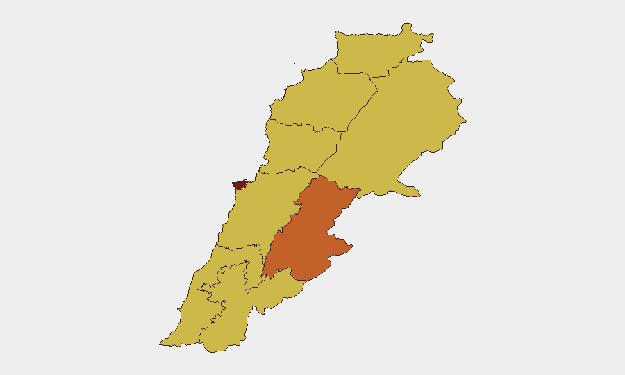
Beirut Governorate dominates risk (90.2), driven by dense urban population, critical infrastructure concentration, and potential for secondary effects from cross-border military activity. The southern governorates—South (61.7) and Nabatieh (64.8)—are experiencing direct Israeli military operations, Lebanese Army redeployment, and active IED hazards; Beqaa (74.6) remains elevated due to proximity to Syrian border instability and Iranian military presence. North, Akkar, and Mount Lebanon show moderate but persistent risk (60.2) from spillover effects and logistical vulnerability. Personnel and asset exposure is highest in Beirut and the South; operations in Beqaa and border zones carry elevated threat from conventional military engagement and non-state actor activity.
How GeoBit Would Assist
Corporate security teams should deploy AOI Monitoring & Early Warning on Beirut and southern Lebanon to detect escalation in real time; Intel Sweep and X/Twitter OSINT to track statements by Lebanese, Israeli, Iranian, and U.S. actors signaling tactical shifts; and Routing & Network Analysis to model alternative supply-chain and personnel-movement corridors away from high-risk governorates. Conflict & Military battle mapping and Satellite & Imagery analysis enable tracking of force positions and airfield/port status, informing duty-of-care decisions on evacuation readiness and business continuity.
7-Day Outlook
Israeli and Lebanese military operations will likely continue in parallel—Israeli strikes on stated military targets and Lebanese Army consolidation of pilot zones—creating persistent friction and IED risk. Ceasefire implementation remains fragile; any major escalation event (significant Israeli strike, Hezbollah retaliation, or LAF casualty spike) could trigger rapid deterioration and forced evacuation scenarios. Monitoring military communications, Lebanese government statements, and U.S. diplomatic signals will be critical to early warning of trajectory change.
Highest-Risk Areas — Ranked
| # | State / Region | Risk |
|---|---|---|
| 1 | Beirut Governorate | 90.2 |
| 2 | Beqaa Governorate | 74.6 |
| 3 | Keserwan-Jbeil Governorate | 64.8 |
| 4 | Nabatieh Governorate | 64.8 |
| 5 | Baalbek-Hermel Governorate | 62.3 |
| 6 | South Governorate | 61.7 |
| 7 | North Governorate | 60.2 |
| 8 | Akkar Governorate | 60.2 |
| 9 | Mount Lebanon Governorate | 60.2 |
Sources
Previous Daily Briefs
A new Lebanon brief is written every day — each with its own risk map and downloadable CSV. Here's the last week; use the calendar to go further back.
📅 Browse every day by calendar →
Highlighted days have a brief. Tap a day for that day's map & analysis, or “csv” for that day's dataset ($5).
Atlas — our AI intelligence desk — emails them this snapshot personally. Nothing else, no list.