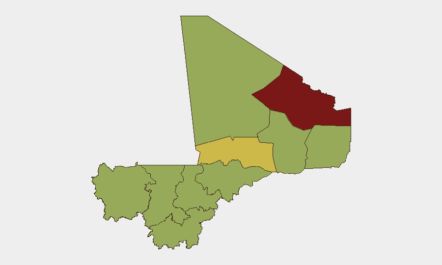
Situation Summary
Mali faces an acute security crisis following a coordinated multi-site insurgent offensive on 5 July 2026, with simultaneous attacks on military positions, a prison complex, and civilian infrastructure across northern and central regions. The offensive involved Tuareg-led and jihadist elements targeting army footholds in Kidal, Gao, Mopti, and the capital region, signaling a significant escalation in insurgent coordination and operational capacity. Despite government claims that the situation remains "under control," damage assessments are ongoing and multiple locations remain contested or under active military response. The trajectory points toward sustained high-tempo operations in the near term, with particular pressure on already-fragile army positions in the north.
Key Developments
- Kenieroba Prison Complex, Bamako region – 5 July 2026
Insurgents launched a sustained assault on the Kenieroba detention facility holding jihadist and other security detainees in the early morning; army confirmed gunfire and ongoing engagement with prisoners reporting active combat.
- Anefis, Kidal region – 5 July 2026
Tuareg-led Azawad Liberation Front (FLA) forces attacked Malian army and Russian paramilitary positions; FLA claims capture of several positions while residents report heavy ongoing fighting and contested control of the town.
- Aguelhok, Kidal region – 5 July 2026
Insurgent elements attacked Malian army positions in Aguelhok, one of the last remaining northern army footholds, as part of the coordinated multi-locality offensive wave.
- Gao, northern Mali – 5 July 2026
Residents reported sustained gunfire and explosions near an army camp in early morning hours, consistent with synchronized insurgent operations across the north.
- Sevare, Mopti region – 5 July 2026
Multiple explosions occurred around 05:00 local time, followed by military aircraft operations; origin of blasts unclear but linked to the broader coordinated insurgent offensive.
- Coordinated Multi-Site Offensive – 5 July 2026
Malian armed forces confirmed at least five simultaneous attack locations (Anefis, Aguelhok, Gao, Sevare, Kenieroba), indicating significant operational planning and resource coordination by insurgent actors.
Highest-Risk Areas
Kidal region dominates the threat landscape (risk score 84.7), driven by sustained Tuareg separatist and insurgent activity and the presence of contested military positions; Timbuktu (67.7) remains a secondary focus for jihadist and insurgent cells. Bamako's elevated risk (56.7) reflects the prison assault and the capital's role as a political and security decision-making center under pressure. Northern regions—Ménaka, Taoudénit, Gao, and the Gao corridor—carry uniform elevated scores (54.7 each), reflecting the geographic concentration of insurgent capacity and minimal state control outside garrison towns. Central Mopti (54.7) has emerged as a secondary conflict theater and logistical hub for insurgent movement between north and south.
How GeoBit Would Assist
AOI Monitoring & Early Warning with persistent watch on Kidal, Gao, Mopti, and Bamako would generate alerts on subsequent attack planning or force concentrations before execution. Battle Mapping and Force Structure analysis would track contested control of towns (Anefis, Aguelhok, Sevare) and allow security teams to model likely army vs. insurgent maneuver. OSINT Fusion (social media, Telegram, radio SIGINT) would corroborate insurgent claims, identify emerging faction leadership, and assess public morale shifts that precede secondary operations.
7-Day Outlook
Insurgent momentum is likely to drive follow-on attacks on secondary army positions and supply lines within 7–14 days, particularly if initial assaults on Anefis or Aguelhok succeed in dislodging government forces. Counteroffensive response by Malian and Russian paramilitary elements is expected but may take 3–5 days to mobilize. Civilian movement and humanitarian access in Kidal, Gao, and Mopti regions should be expected to deteriorate sharply.
Highest-Risk Areas — Ranked
| # | State / Region | Risk |
|---|---|---|
| 1 | Kidal | 84.7 |
| 2 | Timbuktu | 67.7 |
| 3 | Bamako | 56.7 |
| 4 | Ménaka | 54.7 |
| 5 | Kayes | 54.7 |
| 6 | Taoudénit Region | 54.7 |
| 7 | Gao | 54.7 |
| 8 | Koulikoro | 54.7 |
| 9 | Ségou Region | 54.7 |
| 10 | Sikasso Region | 54.7 |
| 11 | Mopti | 54.7 |
Previous Daily Briefs
A new Mali brief is written every day — each with its own risk map and downloadable CSV. Here's the last week; use the calendar to go further back.
📅 Browse every day by calendar →
Highlighted days have a brief. Tap a day for that day's map & analysis, or “csv” for that day's dataset ($5).
Atlas — our AI intelligence desk — emails them this snapshot personally. Nothing else, no list.