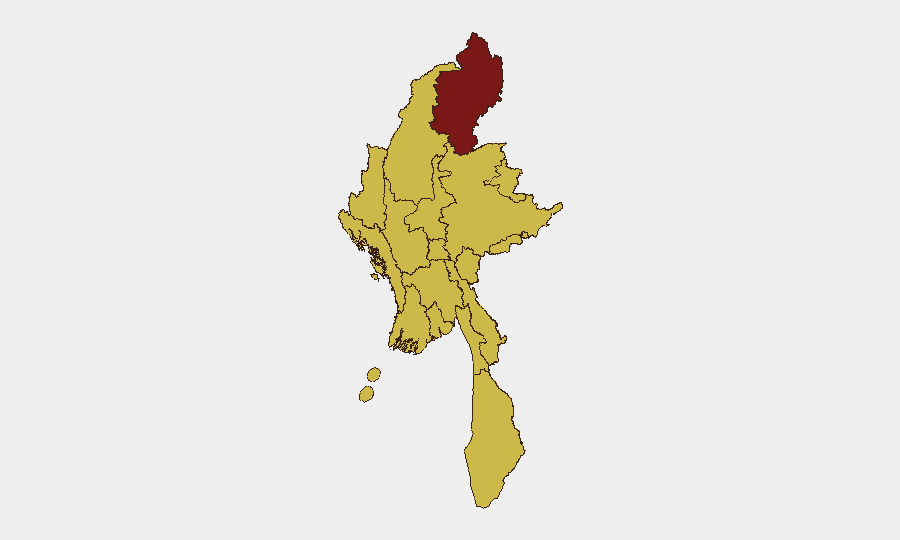
Situation Summary
Myanmar remains in active civil conflict following the February 2021 coup, with nationwide casualty estimates now exceeding 100,000 deaths. The security environment is characterized by decentralized insurgent activity, junta counteroffensives, and regional instability, particularly along the Bangladesh border and in ethnic-minority states. A localized but significant spike in air and ground operations in western Rakhine State (6–7 July) represents the most recent tactical escalation, triggering cross-border security responses in Bangladesh and heightened displacement risk.
Key Developments
- Maungdaw Township, Rakhine State (6–7 July 2026): Myanmar military conducted multiple airstrikes against suspected Arakan Army positions and adjacent villages in northern Rakhine, with residents reporting sustained aircraft noise, explosions, and population movement toward the Bangladesh border.
- Bangladesh–Myanmar border, Cox's Bazar sector (6–7 July 2026): Bangladesh Border Guard Bangladesh reinforced patrols and increased alert posture opposite Maungdaw and surrounding areas in response to reported Myanmar air and ground operations; authorities cited concern over cross-border fire, refugee inflows, and potential incursions.
- Maungdaw–Buthidaung coastal axis, Rakhine State (6–7 July 2026): Regional security feeds reported a series of junta air sorties targeting suspected insurgent supply routes along the northern coastal belt, with local reporting consistent with a sharp 1–2 day spike in air operations intensity.
- Western Myanmar conflict zone (6–7 July 2026): Cross-border monitoring accounts documented heightened conflict activity just inside Myanmar territory opposite Bangladesh, including artillery and airstrikes, with explicit warning of possible further displacement and security spillover.
Highest-Risk Areas
Kachin State (risk 100) remains the single highest-risk sub-national zone, driven by ongoing insurgent–junta combat and limited humanitarian access. However, the current 24–48 hour tactical picture is dominated by activity in Rakhine State (risk 70), where the Arakan Army and allied forces are actively engaged with military air and ground assets along the Bangladesh border. Tanintharyi, Shan, Chin, Sagaing, and Wa State all carry composite risk scores of 70 and represent sustained conflict zones; all major urban centers (Yangon, Mandalay, Naypyitaw) remain at risk level 70 due to lingering civil unrest, militia activity, and checkpoint-based security threats. The concentration of current tactical activity in Rakhine and the corresponding border alert in Bangladesh underscore elevated near-term displacement and cross-border incident risk in that region specifically.
How GeoBit Would Assist
Security teams with personnel or assets in Myanmar should deploy AOI Monitoring & Early Warning against Kachin, Rakhine, and Shan State to receive real-time alerting on conflict spikes, displacement events, and military operations. Multi-language OSINT (X/Twitter, Telegram, local media) combined with sentiment and temporal analysis will clarify the timing, location, and civilian impact of ongoing airstrikes and ground action, enabling rapid duty-of-care decisions. GIS & Spatial Analysis and alternative route/journey planning allow security teams to identify safe corridors and avoid active conflict zones during personnel movement within urban centers and transit corridors.
7-Day Outlook
The current tempo of Rakhine operations is likely to persist or intensify over the next 7 days given junta force posture and Arakan Army presence. Border tension with Bangladesh will remain elevated, increasing the risk of cross-border incidents and refugee movement. No major new nationwide escalation is forecast, but localized flare-ups in Kachin, Shan, and Sagaing remain probable as seasonal monsoon conditions and operational windows shift.
Highest-Risk Areas — Ranked
| # | State / Region | Risk |
|---|---|---|
| 1 | Kachin State | 100 |
| 2 | Tanintharyi Region | 70 |
| 3 | Shan State | 70 |
| 4 | Chin | 70 |
| 5 | Sagaing Region | 70 |
| 6 | Wa State (Northern Region) | 70 |
| 7 | Magway | 70 |
| 8 | Mandalay | 70 |
| 9 | Rakhine | 70 |
| 10 | Ayeyarwady | 70 |
| 11 | Yangon | 70 |
| 12 | Naypyitaw Union Territory | 70 |
Sources
Previous Daily Briefs
A new Myanmar brief is written every day — each with its own risk map and downloadable CSV. Here's the last week; use the calendar to go further back.
📅 Browse every day by calendar →
Highlighted days have a brief. Tap a day for that day's map & analysis, or “csv” for that day's dataset ($5).
Atlas — our AI intelligence desk — emails them this snapshot personally. Nothing else, no list.