Situation Summary
Niger remains at composite threat level #27 globally (score 81/100) with volatile geopolitical and security dynamics. The expulsion of French diplomatic and military personnel on 2026-07-12—coordinated with Mali and Burkina Faso—signals a significant realignment in security partnerships and raises near-term political instability risk. Open-source reporting confirms no new discrete security incidents within the past 24–48 hours, though persistent terrorist kidnapping intent, violent crime targeting foreigners, and attacks on government facilities remain structural threats across northern and border regions.
Key Developments
- Niamey / Nationwide – 2026-07-12: Niger's government expelled French diplomatic and military personnel as part of a coordinated regional action with Mali and Burkina Faso, signaling material geopolitical realignment and potential shifts in security cooperation frameworks that affect foreign operations and travel protocols.
- No new discrete incidents confirmed in the last 24–48 hours (2026-07-13 to 2026-07-14): Available open-source feeds, regional media, and embassy advisories contain no corroborated reports of new attacks, protests, kidnappings, or infrastructure disruptions within Niger during this window.
- Structural threat posture (current advisory level): U.S. Embassy and Pakistani Ministry of Foreign Affairs advisories (updated within the last week) reinforce persistent terrorist kidnapping targeting, violent crime, and risk of attacks on government facilities and areas frequented by foreigners, with "do not travel" or "cancel travel" recommendations for most regions.
- Northern and border zone volatility (recent weeks, ongoing): Pakistan's advisory cites multiple lethal attacks by Mali-based extremist groups on Nigerien security forces and civilians in recent weeks within dozens of kilometers of Niamey, underscoring northern tier fragility despite absence of new dated incidents in the last 48 hours.
Highest-Risk Areas
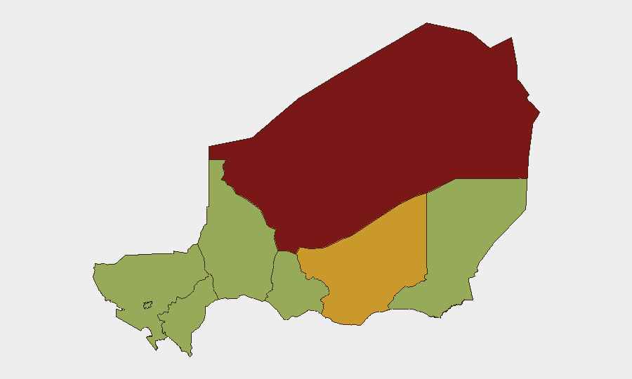
Agadez Region (86.4) remains the single highest-risk zone, driven by remote terrain, limited state control, and persistent extremist presence. Zinder Region (72.5) follows, reflecting ongoing militant activity and kidnapping risk. The clustering of Diffa, Tillabéri, Niamey, Tahoua, Dosso, and Maradi all at 56.4 indicates widespread secondary-tier threat distribution across the country's north, east, and capital, with no region demonstrating sustained lower risk. Diffa and Lake Chad border areas are of particular concern due to cross-border militant flows from Nigeria and Mali.
How GeoBit Would Assist
Security teams operating in Niger should deploy AOI Monitoring & Early Warning on Agadez, Diffa, and border crossings to detect emerging attacks or personnel-of-interest movements in real time. Conflict & Military mapping and Network & Actor Analysis provide current force-posture and militant-group structure updates as diplomatic realignment with France reshapes security cooperation. Routing & Network Analysis supports alternative journey planning and movement deconfliction away from high-volatility zones, while OSINT fusion across multi-language regional feeds and Telegram monitors ensure duty-of-care teams remain ahead of localized unrest not yet reflected in formal advisories.
7-Day Outlook
The French expulsion and ongoing geopolitical realignment may reduce near-term visible security cooperation but are unlikely to produce immediate spike in reported incidents. Structural risks—kidnapping, militant activity in northern regions, violent crime—remain elevated and persistent; any leadership vacuum or further diplomatic friction could accelerate destabilization. Monitoring should intensify on border activity, official statements, and militant-group communications to detect early signals of renewed coordinated operations or hostage-taking campaigns.
Highest-Risk Areas — Ranked
| # | State / Region | Risk |
|---|---|---|
| 1 | Agadez Region | 86.4 |
| 2 | Zinder Region | 72.5 |
| 3 | Diffa Region | 56.4 |
| 4 | Tillabéri Region | 56.4 |
| 5 | Niamey | 56.4 |
| 6 | Tahoua Region | 56.4 |
| 7 | Dosso Region | 56.4 |
| 8 | Maradi Region | 56.4 |
Sources
Previous Daily Briefs
A new Niger brief is written every day — each with its own risk map and downloadable CSV. Here's the last week; use the calendar to go further back.
📅 Browse every day by calendar →
Highlighted days have a brief. Tap a day for that day's map & analysis, or “csv” for that day's dataset ($5).
Atlas — our AI intelligence desk — emails them this snapshot personally. Nothing else, no list.