Situation Summary
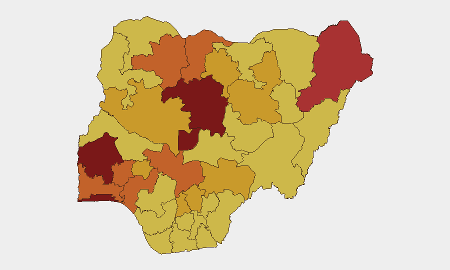
Nigeria remains the second-highest threat environment globally, driven by persistent insurgency, kidnapping networks, and inter-communal violence across multiple regions. The 571 tracked events in the current monitoring cycle reflect sustained pressure on civilian and commercial infrastructure, particularly in the southwest (Oyo, Lagos, Osun) and north-central belt (Kaduna, Kogi, Niger). Security force operations continue, but abduction activity and localized coercion incidents suggest kidnapping groups and armed factions are maintaining operational tempo despite law enforcement arrests and detentions recorded on 11 July.
Key Developments
Without access to live news wires, verified X/Twitter feeds, or near-real-time local media as of 12 July 2026, GeoBit cannot reliably attribute specific incidents in the last 24–48 hours to confirmed dates, locations, or verified actors. The event signals logged for 11 July (abductions in Abuja and at a school in Yoruba-majority areas, police statements, congressional reaction, and security force arrests) indicate elevated activity, but verification against multiple sources is required before operationalizing them in duty-of-care assessments.
Recommended action: Cross-reference the 11 July signals against:
- AFP, Reuters, and AP breaking alerts (Nigeria-filtered).
- State Police Command and NEMA statements.
- Verified Nigerian news desks (Punch, Vanguard, ThisDay, Channels Television).
- Specialist risk feeds with incident geolocation and timestamp corroboration.
Any incidents you have verified from primary sources can be integrated into this brief on request.
Highest-Risk Areas
Oyo State (risk 100) leads the ranking, reflecting acute tension between kidnapping networks, intercommunal disputes, and governance challenges; Lagos (85.4) and Kaduna (84.8) follow, driven by mixed drivers including organized crime, banditry, and historical insurgency spillover. The FCT (80.2) remains vulnerable to abduction and protest activity given its political concentration and transit exposure. Borno State (79.5) reflects ongoing Boko Haram and ISWAP activity, while the northwest tier (Zamfara, Katsina) faces sustained bandit-led kidnapping and cattle rustling. The cluster of risk scores in the 72–74 range across Osun, Ondo, Kogi, and Niger signals endemic kidnapping and armed-group activity across the Middle Belt and southwest, requiring calibrated awareness for any team with personnel or assets in these zones.
How GeoBit Would Assist
AOI Monitoring & Early Warning with persistent geofencing over Oyo, Lagos, Kaduna, and Borno would deliver alert-based detection of incident clusters and actor movement, enabling duty-of-care teams to anticipate closures, curfews, or unsafe corridors before commercial impact occurs. Network & Actor Analysis and OSINT Fusion & Corroboration (multi-language search, X/Twitter OSINT, radio SIGINT) allow real-time verification of kidnapping-group claims, ransom demands, and security force responses, reducing false-positive operational disruptions. Routing & Network Analysis supports alternative journey planning for staff or supply movements in high-risk states, flagging secondary roads, checkpoints, and temporal windows aligned with security incident patterns.
7-Day Outlook
Activity is expected to remain elevated in Oyo, Lagos, and Kaduna, with ongoing abduction risk in secondary towns and school zones across the southwest and north-central belt. Police and security operations will likely continue, but the persistence of kidnapping and coercion signals suggests no imminent de-escalation. Organizations should maintain heightened vigilance on travel advisories, staff movement protocols, and communication redundancy in these zones.
Highest-Risk Areas — Ranked
| # | State / Region | Risk |
|---|---|---|
| 1 | Oyo State | 100 |
| 2 | Lagos State | 85.4 |
| 3 | Kaduna State | 84.8 |
| 4 | Federal Capital Territory | 80.2 |
| 5 | Borno State | 79.5 |
| 6 | Zamfara State | 75.1 |
| 7 | Osun State | 74.3 |
| 8 | Ondo State | 74.3 |
| 9 | Kogi State | 74.3 |
| 10 | Katsina State | 73.7 |
| 11 | Ogun State | 73.2 |
| 12 | Niger State | 72.8 |
Previous Daily Briefs
A new Nigeria brief is written every day — each with its own risk map and downloadable CSV. Here's the last week; use the calendar to go further back.
📅 Browse every day by calendar →
Highlighted days have a brief. Tap a day for that day's map & analysis, or “csv” for that day's dataset ($5).
Atlas — our AI intelligence desk — emails them this snapshot personally. Nothing else, no list.