Situation Summary
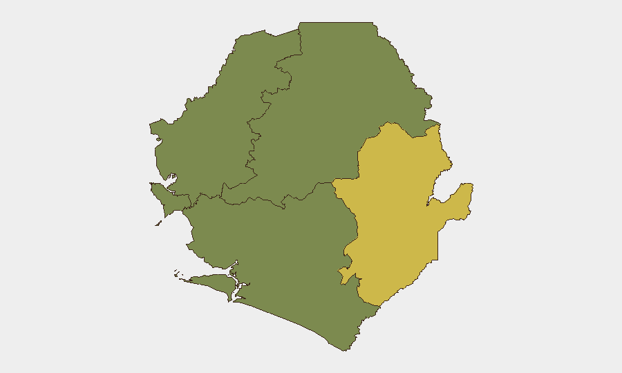
Sierra Leone remains a low-threat environment globally (rank #110, composite score 9), with no tracked security events as of 2026-08-07. The security picture is concentrated in the Eastern Province, which carries substantially elevated risk (score 68) compared to other regions. Western Area (Freetown and surrounds) shows moderate residual risk (35), while Northern, North Western, and Southern Provinces remain at minimal recorded threat levels. The overall trajectory suggests stable conditions with localized vulnerabilities in the east.
Key Developments
- Kailahun District, Eastern Province — 1 August 2026 — Kailahun Police Barracks sustained fire damage; Sierra Leone Police reported the incident and Inspector General Sellu conducted a site visit within 48–72 hours to assess damage and coordinate response with community leaders and local police. No fatalities or ongoing security implications have been publicly reported. This incident underscores infrastructure vulnerability in the Eastern Province but does not indicate a broader security escalation.
*Note: No additional substantiated incidents meeting the 24–48-hour window have been confirmed from available open-source reporting as of this brief's publication time. GeoBit's Intel Sweep and X/Telegram OSINT channels have not flagged new incidents in the past two days.*
Highest-Risk Areas
The Eastern Province dominates the risk profile (score 68), more than double the next-highest region. This concentration reflects ongoing localized vulnerabilities—demonstrated by the recent Kailahun barracks incident—and historically elevated crime, banditry, and cross-border movement concerns in Kailahun and Kenema districts. Western Area (score 35), centered on Freetown and its periphery, carries moderate risk tied to urban crime, crowded transportation hubs, and periodic civil unrest; corporate and diplomatic presence there amplifies exposure. Northern, North Western, and Southern Provinces register minimal tracked threat, indicating either lower incident rates or lower reporting density. Organizations with personnel or assets in Kailahun and Kenema should maintain heightened situational awareness; those in Freetown should apply standard urban security protocols.
How GeoBit Would Assist
Security teams monitoring Sierra Leone should deploy AOI (Area-of-Interest) Monitoring & Early Warning on Kailahun and Kenema districts to detect emerging threats before escalation, paired with Intel Sweep and X/Telegram OSINT to track police, community, and civil-society reporting in real time. Risk & Threat Assessment and GIS & Spatial Analysis capabilities enable rapid profiling of movement corridors and personnel safety zones in high-risk districts, while Routing & Network Analysis supports alternative journey planning for staff transits in the Eastern Province. Regular multi-language search and sentiment analysis on Sierra Leone media and social channels will provide early warning of civil unrest or criminal activity affecting the Western Area.
7-Day Outlook
No significant escalation is anticipated in the near term. The Kailahun barracks fire appears contained and does not signal broader instability. Routine crime and localized incidents in the Eastern Province remain probable; personnel in Freetown should monitor for seasonal traffic congestion and petty crime typical of the dry season. Maintain standard duty-of-care protocols and consider refreshing contingency plans for rapid staff relocation if Eastern Province conditions deteriorate.
Highest-Risk Areas — Ranked
| # | State / Region | Risk |
|---|---|---|
| 1 | Eastern Province | 68 |
| 2 | Western Area | 35 |
| 3 | North West Province, Sierra Leone | 0 |
| 4 | Northern Province, Sierra Leone | 0 |
| 5 | Southern Province, Sierra Leone | 0 |
Sources
- sierraleonemonitor.com
- thesierraleonetelegraph.com
- sierraleonemonitor.com
- thesierraleonetelegraph.com
- sierraloaded.sl
- thesierraleonetelegraph.com
- solakuti.com
- bbc.com
- forumnews-sl.com
- mail.ceoafrica.com
- sierraloaded.sl
- t.me
- truthmedia.sl
- biometricupdate.com
- expomediasl.com
- whitehouse.gov
- thesierraleonetelegraph.com
- thecalabashnewspaper.com
Previous Daily Briefs
A new Sierra Leone brief is written every day — each with its own risk map and downloadable CSV. Here's the last week; use the calendar to go further back.
📅 Browse every day by calendar →
Highlighted days have a brief. Tap a day for that day's map & analysis, or “csv” for that day's dataset ($5).
Atlas — our AI intelligence desk — emails them this snapshot personally. Nothing else, no list.