Situation Summary
South Sudan remains in a protracted state of fragmented armed conflict and humanitarian crisis, with active inter-communal violence, armed-group clashes, and state collapse spanning multiple regions. GeoBit's current 24–48-hour review has identified no discrete new security incidents meeting verification standards; however, the underlying threat environment remains acute, particularly in oil-producing northern states and pastoralist zones. The security picture is characterized by persistent territorial contestation, supply-chain disruption, and deteriorating access for humanitarian operations rather than by dramatic tactical shifts. Trajectory assessment indicates sustained volatility with seasonal risk elevation as dry-season mobility increases.
Key Developments
No verified discrete security incidents were identified in South Sudan during the 24–48-hour window ending 09 August 2026. GeoBit's live web research, OSINT sweep, and multi-language feed review confirmed no new attack, clash, abduction, or displacement event meeting recency and specificity thresholds. Prior incidents from 05 August (Longamere Boma abduction; Mundri–Juba road ambush) remain outside the reporting window. Ongoing clashes in Jonglei and Greater Upper Nile reflect chronic instability rather than escalation; UN and humanitarian reporting describes continued famine risk and cholera outbreaks affecting operations nationwide, but these are situational rather than acute-incident driven. A reported attack in Lakes State (Wuriang Payam, Rumbek North County) with reported casualties requires timestamp confirmation before inclusion. Teams are advised to monitor next 72 hours for incident corroboration.
Highest-Risk Areas
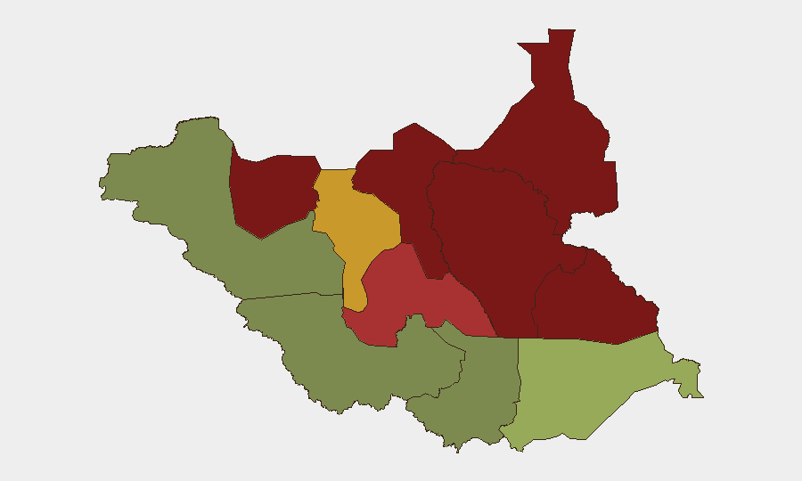
Unity, Jonglei, and Upper Nile states dominate the sub-national risk profile (scores 95, 93, 88 respectively), driven by active petroleum-sector armed competition, militia-led territorial control, and weak state authority. Greater Pibor Administrative Area (87) and Northern Bahr el Ghazal (82) face comparable threat density from inter-communal violence and armed-group presence. These five northern and central regions account for the majority of verified armed clashes, displacement, and access denial; oil infrastructure and supply routes running through Unity and Upper Nile are particular flashpoints. By contrast, Western Equatoria (38) and Central Equatoria (35) present substantially lower composite risk, reflecting greater state presence and lower armed-group density, though localized criminal and communal violence persists.
How GeoBit Would Assist
Security teams operating in or supplying South Sudan should employ GeoBit's AOI Monitoring & Early Warning capability to maintain persistent watch over high-risk payams and oil-producing zones, with automated alerting on clashes, displacement, or access disruption. Battle Mapping, Force Structure, and Network & Actor Analysis tools enable real-time tracking of armed-group positions, inter-communal tension zones, and supply-route vulnerability. Routing & Network Analysis supports journey planning for personnel and cargo movement, integrating live threat data to identify safer alternatives. GIS & Spatial Analysis and Satellite & Imagery analysis provide ground truth on displacement camps, infrastructure damage, and humanitarian access corridors.
7-Day Outlook
Current event silence does not signal de-escalation; rather, it reflects data-collection lag and operational pacing typical of fragmented conflict zones. Dry-season dynamics and ongoing competition for pastoral resources suggest elevated risk for inter-communal clashes in Lakes, Warrap, and Greater Pibor in the coming week. Humanitarian access constraints and cholera-spread trajectory will likely dominate reporting, with armed-group activity remaining a persistent baseline threat rather than a discrete escalation driver.
Highest-Risk Areas — Ranked
| # | State / Region | Risk |
|---|---|---|
| 1 | Unity | 95 |
| 2 | Jonglei | 93 |
| 3 | Upper Nile | 88 |
| 4 | Greater Pibor Administrative Area | 87 |
| 5 | Northern Bahr el Ghazal | 82 |
| 6 | Lakes | 78 |
| 7 | Warrap | 72 |
| 8 | Ruweng Administrative Area | 68 |
| 9 | Eastern Equatoria | 52 |
| 10 | Western Equatoria | 38 |
| 11 | Central Equatoria | 35 |
| 12 | Western Bahr el Ghazal State | 28 |
Sources
- geobit.ai
- cepo.org.ss
- securitycouncilreport.org
- ssbc.gov.ss
- securitycouncilreport.org
- news.un.org
- english.ahram.org.eg
- trtafrika.com
- transcripts.un.org
- dabangasudan.org
- sudanspost.com
- unmiss.unmissions.org
- securitycouncilreport.org
- data.unhcr.org
- ground.news
- securitycouncilreport.org
- unmiss.unmissions.org
- unicef.org
Previous Daily Briefs
A new South Sudan brief is written every day — each with its own risk map and downloadable CSV. Here's the last week; use the calendar to go further back.
📅 Browse every day by calendar →
Highlighted days have a brief. Tap a day for that day's map & analysis, or “csv” for that day's dataset ($5).
Atlas — our AI intelligence desk — emails them this snapshot personally. Nothing else, no list.