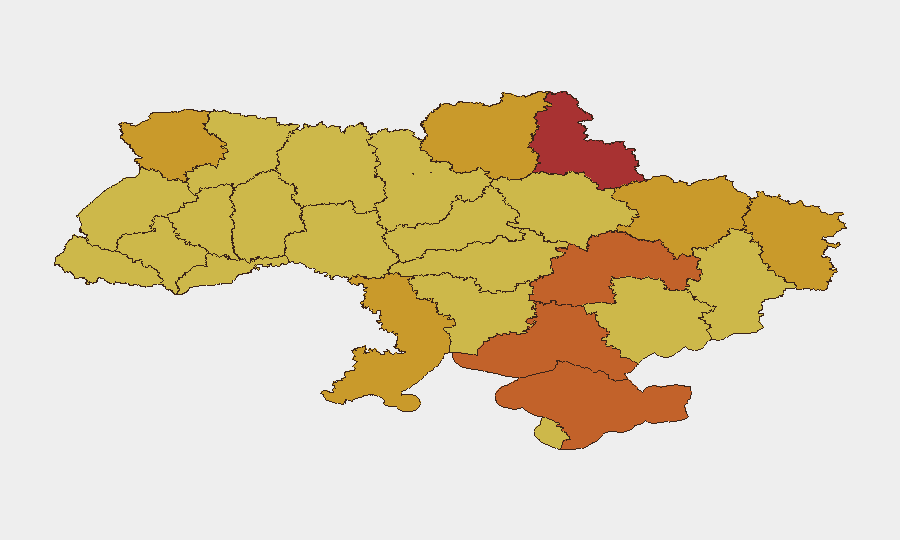
Situation Summary
Ukraine remains the highest global threat environment (composite score 100), driven by sustained conventional warfare and 1,901 tracked security events. The past 24–48 hours show intensified Russian drone and missile strikes against civilian infrastructure and populated areas across multiple oblasts, paired with heavy conventional offensive activity along the Pokrovsk and Kostiantynivka sectors. Casualty figures and infrastructure damage indicate no de-escalation; occupation authorities are simultaneously enforcing political repression in held territories. The security environment remains acute and volatile.
Key Developments
- Kyiv, Kyiv Oblast – 31 July 2026. Russian drone attack on the capital killed 3 people and injured 10; residential areas and civilian infrastructure damaged (per Kyiv Mayor Vitalii Klitschko).
- Odesa, Odesa Oblast – 31 July–1 August 2026. Russian ballistic missile strike on civilian infrastructure killed 2 and injured at least 1; vehicles ignited before containment.
- Nikopol, Dnipropetrovsk Oblast – 1 August 2026. Russian UAV attack on civilian bus injured 16 people, 8 hospitalized, 3 in serious condition.
- Kharkiv, Kharkiv Oblast – 1 August 2026. Geran-3 (Shahed-type) UAV struck residential building and bus stop, injuring 5 and damaging civilian infrastructure.
- Border sectors (Pokrovsk and Kostiantynivka directions) – 1 August 2026. Ukrainian General Staff reported 56–150 daily combat engagements with massive shelling; these sectors identified as most difficult, with heavy drone and guided aerial bomb usage.
- Kherson Oblast (Russian-occupied territory) – 31 July–1 August 2026. Ukrainian authorities report woman convicted of treason and sentenced to 14 years by occupation courts for purchasing Ukrainian war bonds; signals ongoing political repression and legal risk for occupied-area residents.
Highest-Risk Areas
Kyiv remains the top risk (score 100), driven by sustained drone/missile targeting of civilian infrastructure and densely populated areas. Sumy, Kherson, and Dnipropetrovsk Oblasts follow (scores 74.6–76), reflecting both active conventional warfare on or near front lines and Russian air/missile strikes on civilian population centers. Northern and western oblasts (Kharkiv, Volyn, Chernihiv, Lviv) score 70.8–72.4, indicating exposure to shelling, drone activity, and occupation-related legal/political coercion. The concentration of risk in the capital and east-central oblasts reflects the primary axes of conventional conflict and Russia's air campaign targeting civilian morale and logistics infrastructure.
How GeoBit Would Assist
Security teams managing personnel or assets in Ukraine should employ AOI (Area-of-Interest) Monitoring & Early Warning to track drone/missile activity and shelling patterns in real time across key cities and asset locations, with automated alerting on escalations. Battle Mapping and Conflict Intelligence (including force-structure and weapons-capability tracking) provide situational clarity on front-line movement and military pressure, informing evacuation or shelter-in-place decisions. Multi-language OSINT Fusion (X/Twitter, Telegram, local news feeds, sentiment analysis) rapidly corroborates attack reports and occupation-authority actions, enabling duty-of-care teams to assess local governance risk and personnel legal exposure in occupied or contested areas.
7-Day Outlook
Russian air/missile campaign intensity against civilian targets is likely to persist, with drone and ballistic strikes continuing against major cities (Kyiv, Kharkiv, Odesa) and transport corridors. Conventional fighting along Pokrovsk and Kostiantynivka is expected to remain heavy. Occupation authorities will likely continue selective enforcement of treason and collaboration laws in held territories, raising legal and security risk for residents in those zones.
Highest-Risk Areas — Ranked
| # | State / Region | Risk |
|---|---|---|
| 1 | Kyiv | 100 |
| 2 | Sumy Oblast | 76 |
| 3 | Kherson Oblast | 74.6 |
| 4 | Dnipropetrovsk Oblast | 73.9 |
| 5 | Autonomous Republic of Crimea | 73.3 |
| 6 | Odesa Oblast | 72.9 |
| 7 | Kharkiv Oblast | 72.4 |
| 8 | Volyn Oblast | 72.3 |
| 9 | Luhansk Oblast | 71.6 |
| 10 | Chernihiv Oblast | 71.6 |
| 11 | Lviv Oblast | 70.8 |
| 12 | Khmelnytskyi Oblast | 70.8 |
Sources
Previous Daily Briefs
A new Ukraine brief is written every day — each with its own risk map and downloadable CSV. Here's the last week; use the calendar to go further back.
📅 Browse every day by calendar →
Highlighted days have a brief. Tap a day for that day's map & analysis, or “csv” for that day's dataset ($5).
Atlas — our AI intelligence desk — emails them this snapshot personally. Nothing else, no list.