Situation Summary
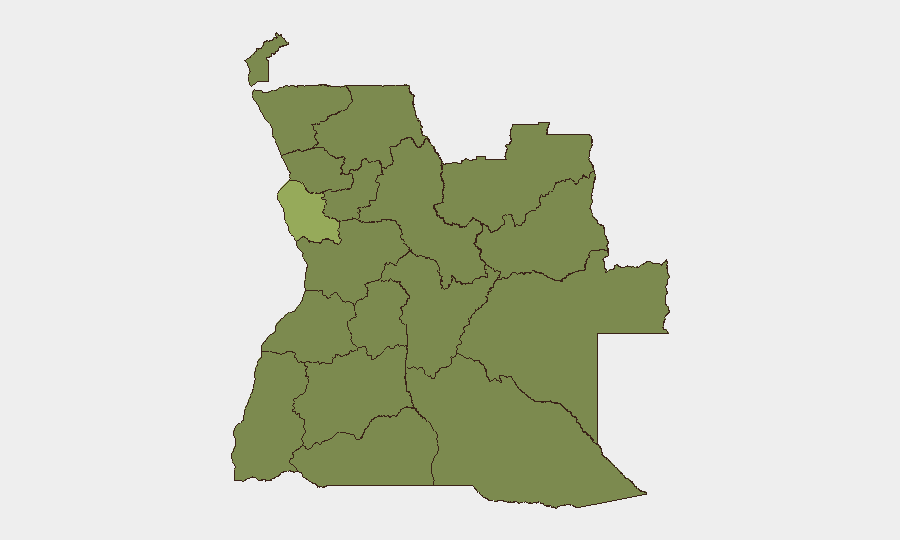
Angola remains a moderate-risk environment (global rank #49) with a composite threat score of 33 across 212 tracked events. The security landscape is dominated by localized wildfire activity and a critical infrastructure disruption affecting nationwide telecommunications. Luanda Province drives the overall risk assessment with a score of 53—substantially above other provinces—while 11 other provinces cluster at a baseline risk of 23, indicating relatively diffuse lower-level threats outside the capital region.
Key Developments
- Nationwide, Angola — 29 July 2026: Unitel, Angola's primary mobile operator, suffered a cyberattack that disrupted voice, mobile data, and internet services across the country. The outage affected more than 21 million customers and was ongoing as of reporting, with restoration efforts in progress. This incident represents a significant single point-of-failure risk for personal, business, and financial communications.
- Multiple locations, Angola — late July 2026: At least 11 distinct wildfire events have been recorded in recent days (IDs: 1029866, 1029815, 1029872, 1029755, 1029756, 1029753, 1029816, 1029817, 1029684, 1029687, 1029796). Specific locations and containment status remain under analysis; wildfires pose secondary risks to supply chains, logistics routes, and air quality in affected regions.
- Public statement issued — 27 July 2026: A neighborhood-level public statement was recorded but specific content and location details are pending full corroboration.
No additional incidents meeting the 24–48-hour recency and verification threshold were identified in live web research.
Highest-Risk Areas
Luanda Province is the dominant risk driver, with a composite score of 53—more than double the baseline score of 23 assigned to all other provinces. This concentration reflects the capital's role as Angola's economic, administrative, and population center, where telecommunications disruptions, criminal activity, and civil unrest carry outsized operational and reputational consequences. The Lunda Norte, Lunda Sul, Cabinda, Zaire, Bengo, Uíge, and Cuanza provinces, along with Malanje, Bié, and Moxico, cluster at uniform baseline risk (23), suggesting either lower incident density or less acute individual event severity outside the capital region. Organizations with operations or personnel in Luanda should prioritize contingency planning for infrastructure disruptions; those in provincial areas should maintain standard due diligence protocols.
How GeoBit Would Assist
Security and risk teams should deploy AOI (Area-of-Interest) Monitoring & Early Warning on Luanda Province and key supply-chain chokepoints to detect emerging incidents before they cascade. Cyber and critical-infrastructure threat monitoring (via Intel Sweep and OSINT fusion) would provide earlier visibility into telecom-sector vulnerabilities and attack patterns; alternative routing and network analysis can help logistics and operations teams identify redundant transport and communication pathways to mitigate single-point failures like the Unitel outage. Environmental & Health monitoring linked to GIS analysis would track wildfire spread, air-quality impacts, and disruption to road networks in real time.
7-Day Outlook
Wildfire activity is likely to persist given seasonal conditions and the frequency of events in the current dataset. The Unitel cyberattack and recovery trajectory should be monitored closely; if restoration is protracted beyond 48 hours, downstream impacts on financial services, supply-chain coordination, and personnel safety protocols will intensify. No indicators of imminent large-scale civil unrest or conflict escalation are evident, but telecommunications resilience remains a critical watch item for duty-of-care operations.
Highest-Risk Areas — Ranked
| # | State / Region | Risk |
|---|---|---|
| 1 | Luanda Province | 53 |
| 2 | Lunda Norte Province | 23 |
| 3 | Lunda Sul Province | 23 |
| 4 | Cabinda Province | 23 |
| 5 | Zaire Province | 23 |
| 6 | Bengo Province | 23 |
| 7 | Uíge Province | 23 |
| 8 | Cuanza Norte Province | 23 |
| 9 | Cuanza Sul Province | 23 |
| 10 | Malanje Province | 23 |
| 11 | Bié Province | 23 |
| 12 | Moxico Province | 23 |
Sources
Previous Daily Briefs
A new Angola brief is written every day — each with its own risk map and downloadable CSV. Here's the last week; use the calendar to go further back.
📅 Browse every day by calendar →
Highlighted days have a brief. Tap a day for that day's map & analysis, or “csv” for that day's dataset ($5).
Atlas — our AI intelligence desk — emails them this snapshot personally. Nothing else, no list.