Situation Summary
Benin remains a moderate-threat environment (global rank #47, composite score 37) where northern departments face significant insurgency and terrorism risks, while southern and coastal zones remain comparatively stable. The country has recorded zero tracked security events in GeoBit's system in recent weeks, though cross-border pressures from Borgu (Niger State, Nigeria) and sporadic criminal violence merit continued monitoring. The 21 August release of cyberactivist Steve Amoussou after a two-year sentence reflects tensions around civil liberties but has not triggered unrest to date.
Key Developments
- Borgu border zone (Nigeria–Benin frontier), 22 August 2026 – Armed bandits attacked multiple communities in Borgu LGA, Niger State (Nigeria), immediately adjacent to the Republic of Benin, kidnapping worshippers near mosques and injuring others with machetes. While the incident occurred on the Nigerian side, it heightens security concern for cross-border road movements and informal crossings in that region.
- Thya village, Kandi commune (northern Benin), 21 August 2026 – Local residents lynched two men accused of cattle theft in what authorities characterized as vigilante justice. The incident signals potential escalation in rural communal tensions around livestock crime in northern Benin.
- Cotonou/national (Benin), 20–21 August 2026 – Cyberactivist Steve Amoussou was released after serving a two-year sentence for alleged political insult and spreading false news. His discharge is a political-justice development; no immediate protests or unrest have been reported.
- Benin City, Edo State (Nigeria), 21–22 August 2026 – The Nigerian Safety Investigation Bureau issued fresh safety recommendations regarding a 23 July runway overrun incident at Oba Akenzua II Airport, flagging concerns about runway conditions and control tower operations. Relevant to air travelers potentially confusing Benin City (Nigeria) with the Republic of Benin.
- Infrastructure (national), 20 August 2026 – Planned electricity cuts were implemented in 13 cities including Cotonou by SBEE; no major new outages or transport blockages have been documented in the last 24–48 hours.
Highest-Risk Areas
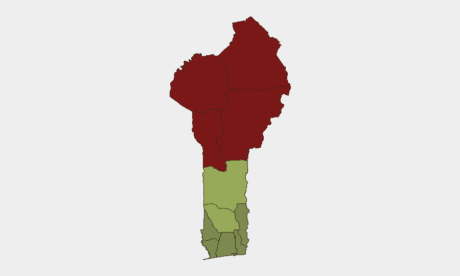
Northern departments—Alibori (risk 92), Atakora (88), Donga (85), and Borgou (83)—dominate the risk landscape, driven by persistent insurgency and terrorism threats that have remained active across the Sahel region. These zones border Mali, Niger, and Nigeria and are vulnerable to spillover from armed-group activity and cross-border bandit incursions, exemplified by the 22 August Borgu raid. Southern departments (Ouémé, Littoral, Atlantique) remain significantly lower-risk, with security concerns concentrated on urban crime and petty violence rather than terrorism. Risk drops sharply below the Zou/Collines belt, making southern Benin a substantially safer operational environment.
How GeoBit Would Assist
Security teams with personnel or assets in Benin should employ Intel Sweep and global event feeds for real-time detection of cross-border incidents and armed-group activity in northern departments. AOI Monitoring & Early Warning on Alibori, Atakora, Borgou, and border crossing zones would provide persistent alerting on emerging threats before they escalate. Routing & Network Analysis can identify secure transit corridors through high-risk northern areas, while conflict and terrorism search capabilities enable rapid assessment of actor movements and tactical shifts affecting expatriate and commercial operations.
7-Day Outlook
No immediate escalation in national-level security is anticipated; however, northern departments will likely experience continued low-intensity criminal and insurgent activity. Vigilance around border-zone cross-traffic and rural banditry should remain elevated, particularly in Kandi and Borgu communes. South-central and coastal regions are expected to remain stable, barring localized crime incidents.
Highest-Risk Areas — Ranked
| # | State / Region | Risk |
|---|---|---|
| 1 | Alibori Department | 92 |
| 2 | Atakora Department | 88 |
| 3 | Donga Department | 85 |
| 4 | Borgou Department | 83 |
| 5 | Zou Department | 45 |
| 6 | Collines Department | 42 |
| 7 | Plateau Department | 38 |
| 8 | Kouffo Department | 35 |
| 9 | Mono Department | 32 |
| 10 | Atlantique Department | 28 |
| 11 | Littoral | 25 |
| 12 | Ouémé Department | 22 |
Sources
Previous Daily Briefs
A new Benin brief is written every day — each with its own risk map and downloadable CSV. Here's the last week; use the calendar to go further back.
- August 20, 2026
- August 18, 2026
- August 16, 2026
- August 14, 2026
- August 12, 2026
- August 11, 2026
- August 10, 2026
📅 Browse every day by calendar →
Highlighted days have a brief. Tap a day for that day's map & analysis, or “csv” for that day's dataset ($5).
Atlas — our AI intelligence desk — emails them this snapshot personally. Nothing else, no list.