Situation Summary
Central African Republic remains at composite threat level 33 globally, with no confirmed discrete security incidents in the last 24–48 hours. The most recent significant event—a 30 June armed attack on a UN/MINUSCA base near Am Dafock in Vakaga prefecture—continues to drive elevated risk in the northeastern border region, though follow-up reporting (7–8 July) reflects MINUSCA's response and displacement consequences rather than new violence. Overall threat posture is stable but fundamentally fragile, with persistent armed-group activity and humanitarian access constraints in frontier prefectures offsetting relative calm in Bangui.
Key Developments
- No verified new security incidents reported in Central African Republic for 13–14 July 2026. All current web intelligence reflects either historical context or follow-up reporting on the 30 June Am Dafock attack (MINUSCA base raid, Vakaga prefecture).
- Am Dafock, Vakaga (30 June – context only): Armed fighters attacked a UN/MINUSCA base near the Sudan border; subsequent reporting (7–8 July) documented MINUSCA security reinforcement and looting of the town's health facility, but no new clashes in the current window.
- Birao displacement (7 July – context only): Humanitarian organizations noted influx of displaced persons into Birao following Am Dafock fighting; this reflects consequences of the earlier incident, not a new development within 13–14 July.
- Vakaga prefecture border activity (ongoing): The northern frontier remains a focal point for armed-group presence and cross-border movement, particularly in areas adjacent to the Sudan border, consistent with historical patterns.
Highest-Risk Areas
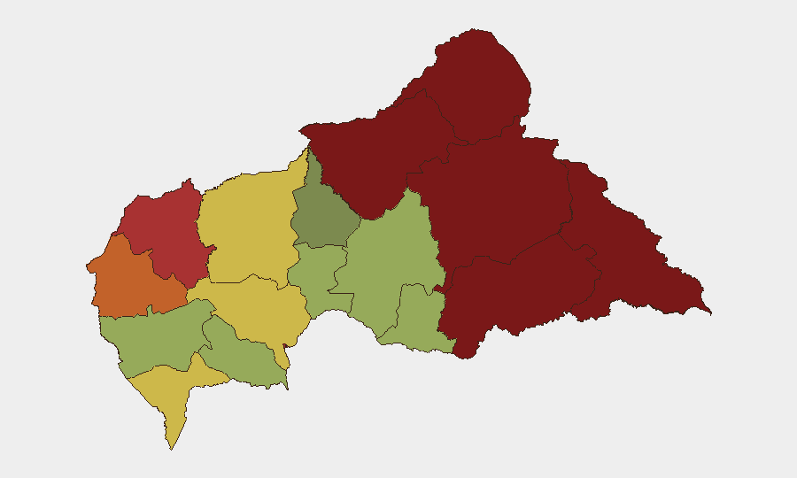
Vakaga prefecture (risk 95) and Bamingui-Bangoran (risk 92) dominate the threat landscape, driven by active armed-group presence, limited state control, and proximity to porous borders (Sudan, Chad). Haute-Kotto and Haut-Mbomou (risks 88 and 85 respectively) present secondary concern zones where access restrictions and remote geography compound monitoring challenges. Bangui itself (risk 78), while lower-ranked, remains operationally significant due to its concentration of expatriate presence, diplomatic missions, and economic assets; risk there reflects localized criminal activity, political volatility, and informal-settlement instability rather than large-scale conflict. The eastern and northeastern prefectures collectively account for the highest activity; southern regions (Sangha-Mbaéré, Ombella-M'Poko) show reduced but non-negligible risk.
How GeoBit Would Assist
Security teams with personnel or assets in CAR should employ AOI Monitoring & Early Warning on high-risk prefectures (particularly Vakaga, Bamingui-Bangoran, and Haute-Kotto) to detect armed-group movement, checkpoint activity, or displacement patterns in real time. Multi-language OSINT (X/Twitter, Telegram, radio SIGINT) and entity extraction would support tracking of armed-group communications and humanitarian alerts across French and local-language channels. GIS & Spatial Analysis and conflict/force-structure mapping can help identify safe routing around known armed-group concentrations and predict chokepoints, especially for road-dependent supply chains or personnel movements in Bangui or frontier regions.
7-Day Outlook
No imminent escalation is forecasted, but the absence of new reported incidents does not imply reduced underlying risk; rather, limited open-source visibility in remote prefectures means threats may emerge without advance warning. Continued MINUSCA reinforcement at Am Dafock and seasonal road degradation during rainy season will restrict armed-group mobility but also limit humanitarian and commercial access. Duty-of-care teams should maintain heightened situational awareness and contingency protocols, particularly for the northeastern corridor.
Highest-Risk Areas — Ranked
| # | State / Region | Risk |
|---|---|---|
| 1 | Vakaga | 95 |
| 2 | Bamingui-Bangoran | 92 |
| 3 | Haute-Kotto | 88 |
| 4 | Haut-Mbomou | 85 |
| 5 | Mbomou | 82 |
| 6 | Ouham-Pendé | 79 |
| 7 | Bangui | 78 |
| 8 | Nana-Mambéré | 75 |
| 9 | Sangha-Mbaéré | 68 |
| 10 | Ouham | 65 |
| 11 | Ombella-M'Poko | 62 |
| 12 | Kémo | 58 |
Sources
Previous Daily Briefs
A new Central African Republic brief is written every day — each with its own risk map and downloadable CSV. Here's the last week; use the calendar to go further back.
📅 Browse every day by calendar →
Highlighted days have a brief. Tap a day for that day's map & analysis, or “csv” for that day's dataset ($5).
Atlas — our AI intelligence desk — emails them this snapshot personally. Nothing else, no list.