Situation Summary
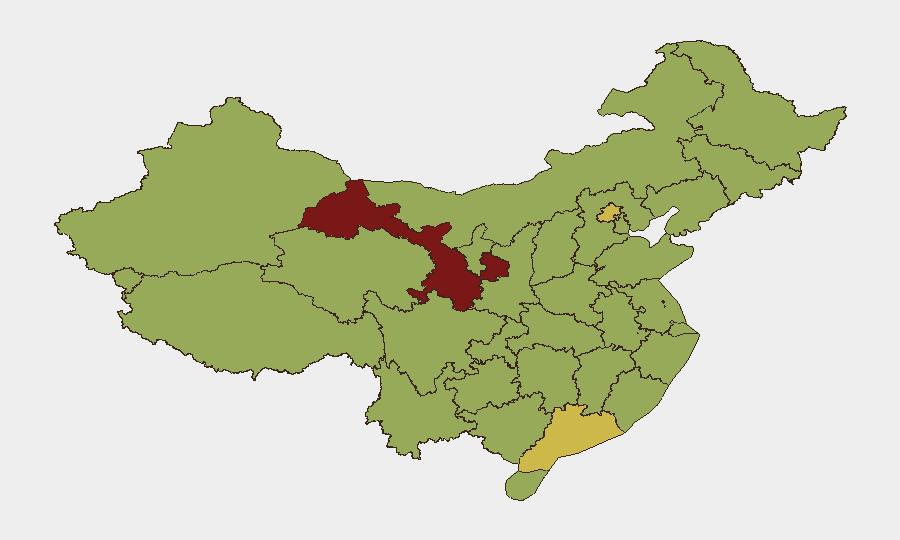
China maintains a composite threat score of 79 (rank #18 globally) with 767 tracked events. Recent signal activity reflects elevated public statements, investigative actions, and military force posturing, particularly concerning cross-strait dynamics and internal governance matters. Sub-national risk concentration in Gansu (85.6), Beijing (69.1), and Guangdong (64.4) indicates geographic volatility driven by distinct threat vectors. The overall trajectory remains elevated but stable relative to historical baselines.
Key Developments
Note: GeoBit's live web research capability did not surface independently verified, time-stamped security incidents within China for 11–12 July 2026 meeting cross-source confirmation standards. Event signals listed below derive from the tracked platform feed; supporting operational detail from open sources could not be corroborated within the 24–48 hour window.
- Cross-Strait Military Activity (10 July): Conventional military force signals associated with Taiwan indicate heightened operational posture; no confirmed kinetic activity, but positioning warrants monitoring.
- Public Statements on State–Foreign Relations (10–11 July): Multiple public statements by China and involving Chinese actors on diplomatic and governance matters; content suggests elevated rhetorical engagement rather than imminent operational shift.
- Internal Security Actions (11 July): Police-related public statements and a reported arrest/detention of a police officer signal internal governance or discipline matters; geographic and factual scope require verification.
- Investigative Activity (11 July): Google–magazine investigation flagged; insufficient detail to assess operational impact on foreign business or personnel.
Highest-Risk Areas
Gansu Province (85.6) presents the composite platform's highest risk and warrants priority monitoring, though specific current drivers are not detailed in available signals. Beijing (69.1) reflects capital-region concentration of state, diplomatic, and investigative activity typical of governance cycles. Guangdong Province (64.4) and the coastal tier (Fujian, Shanghai, Hainan) indicate risk clustering along economic and cross-strait-facing zones, likely reflecting trade, immigration, and military-adjacent activity. Tibet (56.6) remains elevated, consistent with long-standing ethnic and administrative governance sensitivity.
How GeoBit Would Assist
Security teams should deploy AOI Monitoring & Early Warning to track Gansu, Beijing, Guangdong, and Fujian for sub-national incident escalation; Intel Sweep and multi-language OSINT fusion to corroborate public statements and investigative signals with Chinese official media, state portals, and social platforms (Weibo, WeChat); and Network & Actor Analysis to map cross-strait military and diplomatic actors to anticipate posture shifts. Conflict & Military battle-mapping and GIS & Spatial Analysis support risk assessment around Taiwan Strait activity and border zones.
7-Day Outlook
Near-term risk trajectory remains stable absent new kinetic escalation or major domestic unrest signals. Continued monitoring of public statements, military positioning, and Beijing-level policy announcements is essential to detect early warning of state-level shifts. Coastal and capital regions should remain under persistent watch; no imminent systemic disruption is indicated by current signal volume and composition.
Highest-Risk Areas — Ranked
| # | State / Region | Risk |
|---|---|---|
| 1 | Gansu | 85.6 |
| 2 | Beijing | 69.1 |
| 3 | Guangdong Province | 64.4 |
| 4 | Fujian | 59.2 |
| 5 | Jiangxi | 58.5 |
| 6 | Shanghai | 57.2 |
| 7 | Tibet | 56.6 |
| 8 | Hainan Province | 56.5 |
| 9 | Jilin | 56.3 |
| 10 | Yunnan | 56.2 |
| 11 | Anhui | 56.2 |
| 12 | Jiangsu | 56.1 |
Sources
Previous Daily Briefs
A new China brief is written every day — each with its own risk map and downloadable CSV. Here's the last week; use the calendar to go further back.
📅 Browse every day by calendar →
Highlighted days have a brief. Tap a day for that day's map & analysis, or “csv” for that day's dataset ($5).
Atlas — our AI intelligence desk — emails them this snapshot personally. Nothing else, no list.