Situation Summary
Colombia's composite threat score (64/100) reflects an underlying civil conflict environment marked by territorial competition among state and non-state armed actors, criminal enterprises, and governance fragmentation. Over the past 48 hours, signal activity has intensified across government, military, and business channels—including public statements from authorities, police, and banking sectors on July 20–21, alongside military investigations and inter-agency coordination signals on July 19. The trajectory shows active crisis management by state institutions, but no decisive operational breakthrough is evident in available reporting.
Key Developments
- Multi-agency coordination signal (July 19–21). Army investigations, military relation-downgrades, and disapprovals from business and government entities suggest response to a triggering incident, though specific operational details remain opaque in current reporting.
- Police and banking sector statements (July 20–21). Public statements from police and banking institutions signal either precautionary communication or reaction to financial-crime or security-related developments affecting the formal economy.
- Alleged small-arms engagement (July 20). Event stream references small-arms combat attributed to Colombia vs. Mexico actors; verification of location, casualty count, and operational context is not available in current research windows.
- Guerrilla-directed disapproval (July 21). Official disapproval directed at a guerrilla actor suggests active tensions with non-state armed groups; no casualty, location, or specific organizational attribution is confirmed.
- Ongoing ministerial statements (July 19). Multiple ministerial public statements indicate government-level messaging, consistent with crisis communication during periods of heightened armed-group activity or cross-border incidents.
Note: GeoBit's event signal stream reflects actor behavior and institutional moves; full operational context (location, casualty, motive) for July 19–21 incidents is not yet available in open reporting.
Highest-Risk Areas
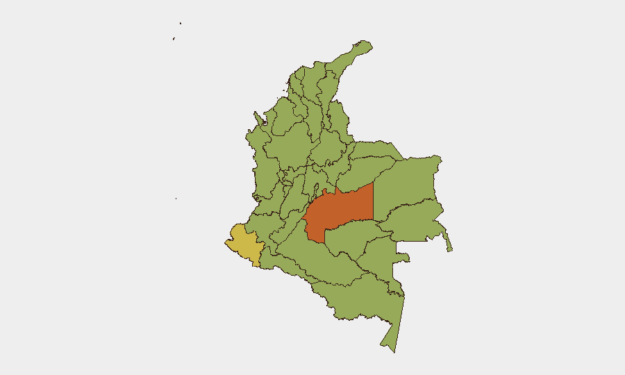
Meta Department (74.8) and Nariño (63) dominate the risk profile, driven by armed-group territorial control, coca cultivation, and trafficking corridors that fund non-state militias. Atlántico (58.4), Antioquia (51.9), and the Capital District (50.7) follow, reflecting a mix of urban gang violence, extortion, and state-capacity challenges. The risk concentration in Meta and Nariño—both remote, coca-rich regions with limited state presence—points to civil-conflict dynamics as the primary structural driver; spillover risk into urban centers (Capital District, Atlántico) and transit zones (Antioquia, Cauca, Valle del Cauca) is persistent.
How GeoBit Would Assist
Teams with personnel or assets in Colombia should prioritize AOI Monitoring & Early Warning on Meta, Nariño, and Cauca departments to detect armed-group movement and trafficking activity before operational escalation. Intel Sweep (global event feeds, OSINT fusion, multi-language search) provides daily signal aggregation and corroboration across government, military, and criminal-actor channels—critical for distinguishing tactical noise from strategic threat shifts. Routing & Network Analysis and GIS & Spatial Analysis enable alternative-route planning and real-time corridor safety assessment for staff travel, particularly in transit zones between high-risk departments.
7-Day Outlook
State institutions are in active response mode; the density of government and military signals suggests short-term crisis management rather than strategic escalation or de-escalation. Barring major operational developments in Meta or Nariño, the risk posture is likely to remain elevated but stable over the next week. Teams should assume continued small-unit activity and maintain heightened situational awareness in travel corridors and urban commercial zones.
Highest-Risk Areas — Ranked
| # | State / Region | Risk |
|---|---|---|
| 1 | Meta Department | 74.8 |
| 2 | Nariño | 63 |
| 3 | Atlántico Department | 58.4 |
| 4 | Antioquia Department | 51.9 |
| 5 | Capital District | 50.7 |
| 6 | Valle del Cauca Department | 49.1 |
| 7 | Cesar Department | 45.9 |
| 8 | Cundinamarca Department | 45.9 |
| 9 | La Guajira | 45.2 |
| 10 | Bolívar Department | 45.2 |
| 11 | Santander Department | 45.2 |
| 12 | Cauca | 45.2 |
Sources
Previous Daily Briefs
A new Colombia brief is written every day — each with its own risk map and downloadable CSV. Here's the last week; use the calendar to go further back.
📅 Browse every day by calendar →
Highlighted days have a brief. Tap a day for that day's map & analysis, or “csv” for that day's dataset ($5).
Atlas — our AI intelligence desk — emails them this snapshot personally. Nothing else, no list.