Situation Summary
Dominican Republic remains a moderate-risk environment globally (rank #101, composite threat score 16), with crime and gang activity as the primary security driver. The country has experienced a series of violent incidents and criminal operations in late August, including armed assaults on civilians, trafficking interdiction, and maritime violence. The threat landscape is concentrated in urban centers and border regions, with no indication of systemic destabilization or major infrastructure collapse as of 28 August 2026.
Key Developments
- 2026-08-27 · Maritime Violence (Caribbean waters, Dominican Republic-flagged vessel): The merchant vessel *Progress IV* caught fire and sank following impact from an unknown projectile. Twelve crew members were rescued; one casualty reported. Cause and perpetrator remain under investigation. This represents an uncommon escalation in maritime targeting within Dominican Republic's operational zone.
- 2026-08-26 · High-Profile Arrest (Santo Domingo area): Armed robbery suspect "Gafita" surrendered to National Police after committing an assault on an ambassador's wife. The arrest signals both criminal activity targeting high-profile individuals and active law-enforcement response. Police are investigating the suspect for multiple additional offenses.
- 2026-08-26 · Civilian Casualties (Santo Domingo): Two separate armed attacks in Santo Domingo resulted in one infant fatality and seven additional wounded. These incidents underscore the exposure of civilians to gang-related crossfire in the capital's highest-risk zones.
- 2026-08-25 · Criminal Gang Dismantlement (location unspecified, multi-agency operation): Dicrim (Dirección de Criminalística) led an operation that located and arrested multiple members of a criminal band linked to repeated armed assaults on businesses and commercial entities. This reflects ongoing police capability to respond to organized crime targeting the private sector.
- 2026-08-21 · Drug Interdiction (maritime, Dominican Republic waters): A 15-hour multi-agency pursuit resulted in interception of a 32-foot speedboat carrying approximately 1.3 tons of cocaine (1,360 packages) and associated contraband. The operation demonstrates both trafficking pressure and active coast-guard and naval response capacity.
- 2026-08-24 · Homicide Investigation (La Cuesta sector, Santo Domingo area): Fatal shooting of a 27-year-old male; alleged shooter Xavier Vidal Féliz Ferreras arrested same day by National Police. Rapid arrest suggests functioning investigative procedures in capital-region incidents.
No verified additional incidents were confirmed in the final 24 hours (27–28 August) via corroborated open-source reporting.
Highest-Risk Areas
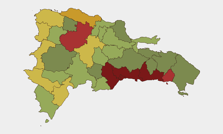
Santo Domingo (risk 92) and Nacional District (risk 88) drive the country's composite threat profile, accounting for the majority of armed assaults, homicides, and gang activity. San Cristóbal (85), San Pedro de Macorís (83), and La Romana (78) form a secondary cluster of urban and periurban risk zones in the south-central region. Northern and border provinces—Santiago (76), Puerto Plata (72), Elías Piña (70), and Dajabón (68)—carry elevated risk linked to trafficking routes and cross-border smuggling networks. Corporate and diplomatic assets concentrated in the capital region face the highest direct exposure to gang violence and armed robbery.
How GeoBit Would Assist
Security teams should deploy AOI Monitoring & Early Warning on Santo Domingo, Nacional District, and key port facilities to detect emerging incidents within 2–4 hours of occurrence. Intel Sweep and multi-language OSINT (X/Twitter, Telegram, local news feeds) will capture gang communications, police operations, and trafficking signals ahead of public announcement. Maritime & Aviation tracking combined with GIS & Spatial Analysis enables real-time monitoring of coastal and border smuggling corridors, vessel movements, and interdiction operations.
7-Day Outlook
No major escalation in gang warfare or security disruption is forecast for the next seven days. Criminal activity will likely remain endemic and geographically concentrated in urban centers and northern border zones. Continued police interdiction operations against trafficking networks and organized robbery cells are expected to proceed incrementally.
Highest-Risk Areas — Ranked
| # | State / Region | Risk |
|---|---|---|
| 1 | Santo Domingo | 92 |
| 2 | Nacional District | 88 |
| 3 | San Cristóbal | 85 |
| 4 | San Pedro de Macorís | 83 |
| 5 | La Romana | 78 |
| 6 | Santiago | 76 |
| 7 | Puerto Plata | 72 |
| 8 | Elías Piña | 70 |
| 9 | Dajabón | 68 |
| 10 | Barahona | 65 |
| 11 | Independencia Province | 64 |
| 12 | La Vega | 62 |
Sources
Previous Daily Briefs
A new Dominican Republic brief is written every day — each with its own risk map and downloadable CSV. Here's the last week; use the calendar to go further back.
- August 27, 2026
- August 26, 2026
- August 25, 2026
- August 24, 2026
- August 23, 2026
- August 22, 2026
- August 21, 2026
📅 Browse every day by calendar →
Highlighted days have a brief. Tap a day for that day's map & analysis, or “csv” for that day's dataset ($5).
Atlas — our AI intelligence desk — emails them this snapshot personally. Nothing else, no list.