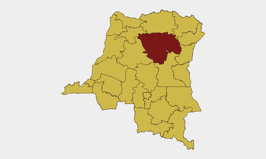
Situation Summary
DR Congo remains in active conflict, ranking #13 globally on composite threat with an escalating eastern front. As of 11 July, UN reporting confirms renewed intensity in South Kivu province involving M23 and Congolese armed forces (FARDC), with documented use of armed drones, heavy artillery, and explosive weapons in civilian areas. The security environment is deteriorating rather than stabilizing despite ongoing peace efforts. Humanitarian access and civilian protection have become acute concerns.
Key Developments
- South Kivu province, 11 July 2026 – UN Human Rights chief Volker Türk reported clashes between FARDC and M23 continuing "unabated," with both sides deploying armed drones and heavy artillery in populated areas, resulting in confirmed civilian casualties and infrastructure damage.
- South Kivu province, 11 July 2026 – UN documentation highlights civilian-populated zones under direct fire from drone strikes and artillery, signaling active tactical escalation rather than static conflict lines.
- Eastern DR Congo, 11 July 2026 – UN statement confirmed recent fighting has caused displacement, injury, and deaths among civilian populations, with urgent calls for humanitarian corridor access and weapons restraint.
- South Kivu province, 11 July 2026 – UN specifically urged immediate cessation of explosive weapons use in civilian areas, indicating elevated risk of further collateral harm.
*Note: Research conducted 12 July 2026 identified four corroborated incidents with UN attribution from the preceding 24 hours. Additional incidents from the wider eastern conflict zone were present in open reporting but lacked specific date-location-source verification sufficient for inclusion in a corporate security brief.*
Highest-Risk Areas
Tshopo province (composite risk 94.2) remains the single highest-threat zone, driven by active conflict intensity and armed-group presence. The secondary tier—Maniema, Sud-Ubangi, Équateur, Nord-Ubangi, Mongala, Lower Uele, Tshuapa, Upper Uele, Ituri, North Kivu, and Lualaba—all score 64.2 and reflect the eastern insurgency belt and resource-extraction zones where armed groups, militia activity, and banditry intersect. South Kivu, while not separately ranked in the top-12 display, is currently the primary active-conflict flashpoint. Organizations with operations or personnel in any of these zones face heightened exposure to armed violence, displacement, and restricted movement.
How GeoBit Would Assist
Security and risk teams operating in DR Congo should deploy persistent Area-of-Interest (AOI) Monitoring & Early Warning on key facilities, supply routes, and personnel locations in Tshopo, South Kivu, and Ituri to receive automated alerts on nearby incidents. Battle Mapping and Force Structure tracking will provide near-real-time visibility of M23, FARDC, and militia positions and movements. Conflict & Military intelligence feeds combined with multi-language OSINT (X/Telegram, regional reporting, UN channels) will sustain 24-hour situational awareness on drone/artillery deployment, humanitarian corridor status, and displacement flows, enabling rapid duty-of-care decisions (evacuation, shelter-in-place, rerouting).
7-Day Outlook
Fighting in South Kivu and the eastern corridor is expected to remain intense over the next week. Civilian displacement and humanitarian strain will likely accelerate. Any negotiation pause remains uncertain; current trajectory suggests sustained operations by both M23 and FARDC, with elevated risk of collateral harm in dual-use and civilian infrastructure. Organizations should expect potential communications disruption, fuel/supply scarcity, and checkpoint volatility.
Highest-Risk Areas — Ranked
| # | State / Region | Risk |
|---|---|---|
| 1 | Tshopo | 94.2 |
| 2 | Maniema | 64.2 |
| 3 | Sud-Ubangi | 64.2 |
| 4 | Équateur | 64.2 |
| 5 | Nord-Ubangi | 64.2 |
| 6 | Mongala | 64.2 |
| 7 | Lower Uele | 64.2 |
| 8 | Tshuapa | 64.2 |
| 9 | Upper Uele | 64.2 |
| 10 | Ituri | 64.2 |
| 11 | North Kivu | 64.2 |
| 12 | Lualaba | 64.2 |
Sources
Previous Daily Briefs
A new DR Congo brief is written every day — each with its own risk map and downloadable CSV. Here's the last week; use the calendar to go further back.
📅 Browse every day by calendar →
Highlighted days have a brief. Tap a day for that day's map & analysis, or “csv” for that day's dataset ($5).
Atlas — our AI intelligence desk — emails them this snapshot personally. Nothing else, no list.