Situation Summary
Eritrea remains fundamentally stable with no confirmed security incidents recorded in the past 24–48 hours. Structural risks persist along all land borders (Ethiopia, Sudan, Djibouti) due to unresolved territorial disputes and spillover from regional conflicts, particularly Sudan's ongoing instability. The capital Asmara and most populated areas remain calm, though authoritarian administrative controls (travel permits, checkpoint detention) remain standard practice. Overall threat trajectory is static rather than escalating.
Key Developments
- Maritime flag-of-convenience incident (Somali/Yemeni waters, 28 August 2026): Eritrea's information ministry clarified on 28 August that the hijacked tanker *Sibu 1*, falsely flagged as Eritrean-registered and diverted off Somalia, is not officially registered in Eritrea and carries an invalid IMO status ("Eritrea False"). The incident itself occurred in waters off Yemen and Somalia, not Eritrean territory, but reflects reputational and maritime-governance risk tied to Eritrea's flag-of-convenience ecosystem.
- No discrete in-country security events reported (Eritrea-wide, 28–29 August 2026): Open-source monitoring and travel advisories issued as recently as 25–27 August confirm absence of new clashes, protests, infrastructure attacks, or major crime incidents inside Eritrea's borders in the reporting window.
- Standing cross-border tension advisories remain current (land borders, as of 27 August 2026): U.S. travel warnings for Ethiopia and multi-source risk syntheses reiterate warnings against all travel within 25–30 km of Eritrea's borders with Ethiopia (particularly Afar Region), Sudan, and Djibouti, citing armed conflict, unrest, and limited consular reach; no new incident has triggered escalation of these advisories.
- Asmara and urban centers assessed as stable and low-crime (as of 25 August 2026): German-language and U.S. travel advisories describe the capital as calm, with petty theft in shared taxis as the primary reported crime concern; no civil unrest or security incidents documented in Asmara or other urban zones in the past 48 hours.
Highest-Risk Areas
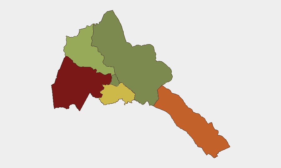
Gash-Barka (risk 92) and Southern Red Sea Region (risk 75) dominate the sub-national ranking, both driven by proximity to multiple borders and historical conflict zones. Gash-Barka's western and northwestern exposure to Sudan and Ethiopia, combined with post-border-war tensions and limited state presence, creates persistent armed-group and cross-border spillover risk. The Southern Red Sea Region faces similar exposure to Ethiopia and Djibouti, with added maritime-security considerations (vessel searches, detention risk). Debub Region (risk 68) shows elevated risk from southern Ethiopia border instability, while Maekel Region (risk 18, containing Asmara) and Northern Red Sea Region (risk 0) remain substantially lower-risk, reflecting greater state control and distance from active conflict zones.
How GeoBit Would Assist
Teams with personnel or assets in Eritrea should leverage GeoBit's AOI Monitoring & Early Warning capability to establish persistent watch on Gash-Barka and Southern Red Sea Region, with alerts configured for cross-border incident activity from Ethiopia and Sudan. Routing & Network Analysis can model safer travel corridors and identify checkpoint/detention-risk zones in advance of field operations. Maritime & Aviation tracking, combined with OSINT fusion (news, official statements, maritime registries), provides real-time visibility into port security posture, vessel routing, and flag-of-convenience misuse that may affect supply chains or personnel transit.
7-Day Outlook
No imminent escalation is expected in-country over the next seven days; Eritrea's internal security posture remains under firm state control. Border-region risks will remain static absent new conflict activity in Sudan or Ethiopia's Afar Region. Maritime incidents involving Eritrean-flagged vessels are likely to persist as a reputational and operational hazard for companies relying on Eritrean ports or shipping routes.
Highest-Risk Areas — Ranked
| # | State / Region | Risk |
|---|---|---|
| 1 | Gash-Barka | 92 |
| 2 | Southern Red Sea Region | 75 |
| 3 | Debub Region | 68 |
| 4 | Anseba | 55 |
| 5 | Maekel Region | 18 |
| 6 | Northen Red Sea Region | 0 |
Sources
Previous Daily Briefs
A new Eritrea brief is written every day — each with its own risk map and downloadable CSV. Here's the last week; use the calendar to go further back.
- August 27, 2026
- August 25, 2026
- August 23, 2026
- August 21, 2026
- August 19, 2026
- August 17, 2026
- August 15, 2026
📅 Browse every day by calendar →
Highlighted days have a brief. Tap a day for that day's map & analysis, or “csv” for that day's dataset ($5).
Atlas — our AI intelligence desk — emails them this snapshot personally. Nothing else, no list.