Situation Summary
Ethiopia remains at elevated security risk (rank #13 globally, composite score 84) driven primarily by ongoing civil conflict across multiple regions. The security environment is characterized by fragmented armed-group activity, intercommunal tensions, and state-level instability rather than a single unified threat. As of 1 August 2026, no discrete, corroborated security incidents have been verified in the preceding 24–48 hours; however, the underlying conflict dynamics across Amhara, Tigray, Oromia, and peripheral regions remain acute and volatile.
Key Developments
GeoBit's consolidated 24–48-hour monitoring window (31 July–1 August 2026) has not yielded corroborated, time-stamped incidents meeting multi-source verification thresholds. Open-source intelligence and regional news feeds contain no newly confirmed clashes, arrest operations, or mass-casualty events with specific location and date stamps falling within this window. The most recent reliably dated conflict reporting (late July) occurs outside the current 24–48-hour horizon.
Note: Older conflict activity in Amhara (late July clashes), Oromia (intercommunal tensions), and Tigray (ongoing displacement) remains documented but predates the current brief window and is provided for context only.
Highest-Risk Areas
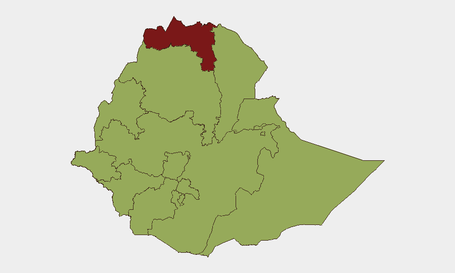
Tigray (88.9) remains the single highest-risk sub-national area, reflecting cumulative displacement, limited humanitarian access, and residual conflict-related instability. Addis Ababa (67.1)—the capital and primary commercial hub—presents elevated urban security risk driven by political tension, protest potential, and state security operations. The eastern and western peripheral regions (Afar, Somali, Benishangul-Gumuz, Gambela, South West Ethiopia Peoples) show equivalent composite scores (58.9) owing to ongoing armed-group presence, limited state control, and intercommunal violence. Amhara and Oromia, as the two most populous regions outside Tigray, carry elevated absolute risk due to their scale, ongoing Fano militia activity (Amhara), and Oromo Liberation Front (OLF) presence, despite not ranking in the top four sub-nationally.
How GeoBit Would Assist
Security teams should deploy GeoBit's AOI Monitoring & Early Warning capability to establish persistent surveillance of Tigray, Amhara, and high-risk Addis Ababa neighborhoods, enabling automated alerting on armed clashes, checkpoints, or mass-gathering activity. Conflict & Military battle mapping and force-structure tracking provide weekly-updated visibility on Fano, OLF, and federal military positioning and operational tempo. OSINT fusion & corroboration across X/Twitter, Telegram, regional media, and radio SIGINT will catch incident-level reporting in real time, reducing the lag between event occurrence and corporate awareness, and entity extraction & sentiment analysis will flag emerging tension signals before violence escalates.
7-Day Outlook
The security trajectory remains static-to-deteriorating: no imminent nationwide collapse is indicated, but regional conflict (particularly Amhara) and displacement pressure will likely persist or intensify. Humanitarian access constraints and health emergencies (recent Marburg signals) may trigger secondary displacement or migration pressure toward Addis Ababa and secondary cities. Organizations with personnel or supply chains in Tigray, Amhara, or the capital should maintain heightened readiness for rapid staff relocation and logistics rerouting.
Highest-Risk Areas — Ranked
| # | State / Region | Risk |
|---|---|---|
| 1 | Tigray | 88.9 |
| 2 | Addis Ababa | 67.1 |
| 3 | Amhara Region | 58.9 |
| 4 | Afar Region | 58.9 |
| 5 | Benishangul-Gumuz Region | 58.9 |
| 6 | Somali Region | 58.9 |
| 7 | Gambela Region | 58.9 |
| 8 | South West Ethiopia Peoples | 58.9 |
| 9 | South Ethiopia Regional State | 58.9 |
| 10 | Central Ethiopia Regional State | 58.9 |
| 11 | Oromia Region | 58.9 |
| 12 | Sidama | 58.9 |
Sources
Previous Daily Briefs
A new Ethiopia brief is written every day — each with its own risk map and downloadable CSV. Here's the last week; use the calendar to go further back.
📅 Browse every day by calendar →
Highlighted days have a brief. Tap a day for that day's map & analysis, or “csv” for that day's dataset ($5).
Atlas — our AI intelligence desk — emails them this snapshot personally. Nothing else, no list.