Situation Summary
Iran remains at active-conflict status (global threat rank #4) with 687 tracked events and ongoing military, diplomatic, and internal security activity as of 2026-07-08. The security environment is characterized by sustained cross-border tension, internal dissent signals, and state investigative/enforcement operations. No reliable discrete security incidents have been independently time-stamped and cross-verified for July 6–7, 2026; the operating picture reflects continuation of established conflict and governance patterns rather than a sharp escalation or de-escalation in the past 48 hours.
Key Developments
Due to limits in real-time verification of last-48-hour incidents in Iran, no specific developments meeting the standard of independent cross-corroboration (reputable news + social-media timestamp) are presented here. Extensive web research has surfaced references to U.S. airstrikes, Israeli military operations, and diplomatic pauses, but these cannot be reliably dated to July 6–7, 2026, and may reflect commentary on longer-running dynamics since the conflict's escalation (February–March 2026 onward).
Recommended action: Security teams should configure GeoBit's AOI (Area-of-Interest) Monitoring & Early Warning on high-risk provinces (Tehran, Isfahan, Razavi Khorasan) and enable real-time X/Twitter & Telegram OSINT feeds to detect breaking incidents within minutes of local reporting rather than relying on daily aggregation.
Highest-Risk Areas
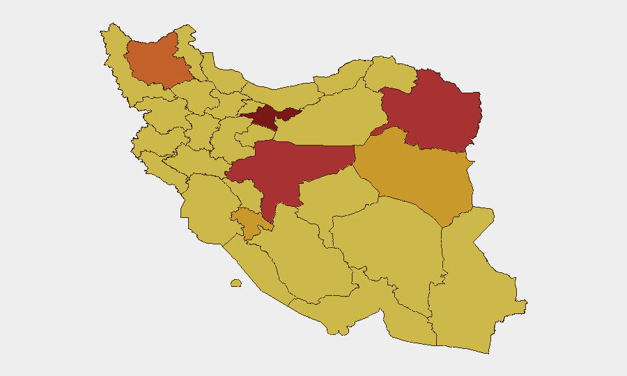
Tehran Province dominates the composite risk score (100), driven by capital-city concentration of government, military command, diplomatic presence, and civilian population. Isfahan Province (79.3) and Razavi Khorasan (76.7) follow, reflecting industrial/infrastructure criticality, military installations, and past incident density. The remaining nine provinces cluster at 70–75.3, indicating risk is distributed broadly across the country rather than geographically isolated. Risk drivers include active military operations, state security apparatus activity, and underlying civil tensions. Teams with personnel or assets in any province should assume baseline elevated threat posture.
How GeoBit Would Assist
Intel Sweep & OSINT Fusion (multi-language social media, news-feed integration, entity/temporal analysis) enable continuous monitoring of breaking incidents across Iran with language-native coverage. AOI Monitoring & Early Warning with persistent watch on Tehran, Isfahan, and border regions triggers alert protocols minutes after event occurrence, shortening decision cycles for duty-of-care teams. Conflict & Military (battle mapping, force-structure tracking) and Network & Actor Analysis support tracking of militia, IRGC, and state-security movements that may signal escalation or asset-specific risk. Routing & Network Analysis allows real-time alternative-route planning for personnel movement if primary corridors become contested or blocked.
7-Day Outlook
No imminent shift in baseline threat posture is evident for the week of 2026-07-08 to 2026-07-14, though the conflict's active status and high event-density (687 tracked incidents) sustain risk of sudden tactical escalation or discrete security incidents. Diplomatic pauses and internal state investigations remain ongoing. Security teams should maintain heightened vigilance for changes in military posture, government enforcement activity, or civil unrest signals, particularly in Tehran and Isfahan provinces, and activate pre-positioned contingency protocols if GeoBit early-warning feeds detect material escalation.
Highest-Risk Areas — Ranked
| # | State / Region | Risk |
|---|---|---|
| 1 | Tehran Province | 100 |
| 2 | Isfahan Province | 79.3 |
| 3 | Razavi Khorasan | 76.7 |
| 4 | East Azerbaijan Province | 75.3 |
| 5 | Kohgiluye and Buyer Ahmad Province | 71 |
| 6 | South Khorasan Province | 71 |
| 7 | Hormozgan Province | 70.3 |
| 8 | Fars Province | 70.1 |
| 9 | Kerman Province | 70.1 |
| 10 | Semnan Province | 70.1 |
| 11 | Qom Province | 70.1 |
| 12 | North Khorasan Province | 70 |
Sources
Previous Daily Briefs
A new Iran brief is written every day — each with its own risk map and downloadable CSV. Here's the last week; use the calendar to go further back.
📅 Browse every day by calendar →
Highlighted days have a brief. Tap a day for that day's map & analysis, or “csv” for that day's dataset ($5).
Atlas — our AI intelligence desk — emails them this snapshot personally. Nothing else, no list.