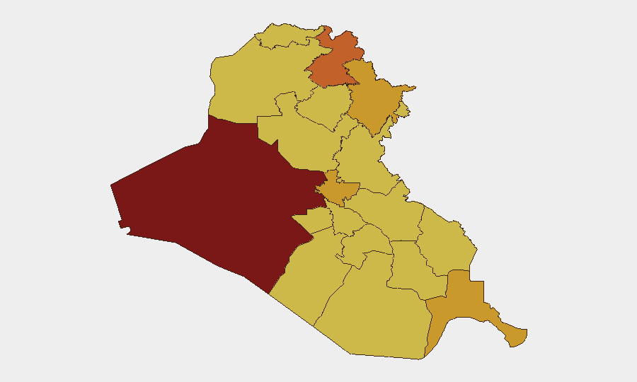
Situation Summary
Iraq remains at elevated composite threat level (#7 globally, score 100) with a sustained drone campaign targeting US diplomatic and coalition assets, particularly in the Kurdistan Region, over the past 48 hours. Multiple swarms of explosive-laden unmanned aerial systems have been intercepted over Erbil and Sulaymaniyah with no reported casualties, yet the pattern signals a significant escalation in aerial threats and regional tensions. The US Embassy in Baghdad has issued urgent warnings of potential Iran-aligned militia attacks in central Baghdad within 24–48 hours and recommended immediate evacuation of US citizens, indicating assessment of imminent risk to diplomatic facilities. Southern maritime infrastructure has also been affected, with drone incidents near the Basra crude export terminal and Faw port prompting temporary export disruptions.
Key Developments
- Erbil, Kurdistan Region – July 17–18, 2026: Coalition and Kurdish air defenses intercepted 8–16 explosive-laden drones across multiple swarm attacks, including three targeting the US consulate area; no casualties or major damage reported, but incident prompted US Embassy security alert.
- Sulaymaniyah, Kurdistan Region – July 17, 2026: Three drones shot down targeting Iranian Kurdish opposition party facilities; part of a sustained aerial campaign across northern Iraq.
- US Embassy Baghdad – July 17–18, 2026: Security alerts issued to US citizens warning of possible airspace closures, travel disruptions, and further attacks; July 18 warning specifically cited Iran-aligned militia threats to central Baghdad within 24–48 hours and recommended immediate evacuation.
- Basra crude export terminal, southern Iraq – July 16, 2026: A drone struck or came down near an oil tanker, prompting brief suspension of crude oil loading at all Iraqi export terminals before resumption; no fire, damage, or casualties confirmed by Iraqi authorities.
- Faw port, Basra Governorate – July 15, 2026: A drone came down within port boundaries with no damage or operational impact, part of back-to-back maritime infrastructure incidents.
- Northern Iraq trend (July 16–18, 2026): Consolidated assessment confirms sustained drone campaign over Kurdistan Region targeting US coalition assets near Erbil and Iranian Kurdish opposition positions; no pattern of mass casualties but indicates significant aerial escalation.
Highest-Risk Areas
Al-Anbar Governorate remains the highest-risk sub-national zone (score 100), though immediate 48-hour threats are concentrated in Erbil (74) and Baghdad (72.5), both experiencing active drone operations and militant threat activity. Sulaymaniyah (72.2) has also seen direct drone attacks on opposition infrastructure. The escalation in Erbil and Baghdad reflects convergence of US diplomatic presence, coalition force positioning, and proxy actor intent; Al-Anbar's ranking reflects chronic instability from residual ISIS networks and militia activity. Southern oil infrastructure in Al-Basra (71) and Dhi Qar (70.7) now faces demonstrated drone delivery capability, a relatively newer attack vector affecting economic resilience.
How GeoBit Would Assist
Security teams with personnel or assets in Iraq should employ AOI Monitoring & Early Warning with persistent watch on Erbil, Baghdad, and southern export terminals for real-time alerting on subsequent drone activity or militia movements. Conflict & Military tracking combined with Network & Actor Analysis would enable continuous mapping of drone-launching positions, militia command networks, and coalition air defense responses. OSINT fusion via multi-language feeds and sentiment & temporal analysis can provide early detection of attack planning signals on Telegram, Twitter, and militia platforms 12–24 hours before operations.
7-Day Outlook
The next 7 days are expected to remain volatile. If the July 18 Baghdad militia threat window passes without major incident, pressure may temporarily ease; however, the underlying pattern of drone capability and Iran-aligned actor willingness to target coalition and diplomatic assets suggests sustained elevated risk through late July. Any escalation in US or coalition response operations could trigger wider militia mobilization across Baghdad, Erbil, and southern regions.
Highest-Risk Areas — Ranked
| # | State / Region | Risk |
|---|---|---|
| 1 | Al-Anbar Governorate | 100 |
| 2 | Erbil Governorate | 74 |
| 3 | Baghdad Governorate | 72.5 |
| 4 | Sulaymaniyah Governorate | 72.2 |
| 5 | Al-Basra Governorate | 71 |
| 6 | Dhi Qar Governorate | 70.7 |
| 7 | Karbala | 70.2 |
| 8 | Al-Najaf Governorate | 70.1 |
| 9 | Nineveh Governorate | 70.1 |
| 10 | Babil Governorate | 70 |
| 11 | Wasit Governorate | 70 |
| 12 | Al-Qadisiyah Governorate | 70 |
Sources
Previous Daily Briefs
A new Iraq brief is written every day — each with its own risk map and downloadable CSV. Here's the last week; use the calendar to go further back.
📅 Browse every day by calendar →
Highlighted days have a brief. Tap a day for that day's map & analysis, or “csv” for that day's dataset ($5).
Atlas — our AI intelligence desk — emails them this snapshot personally. Nothing else, no list.