Situation Summary
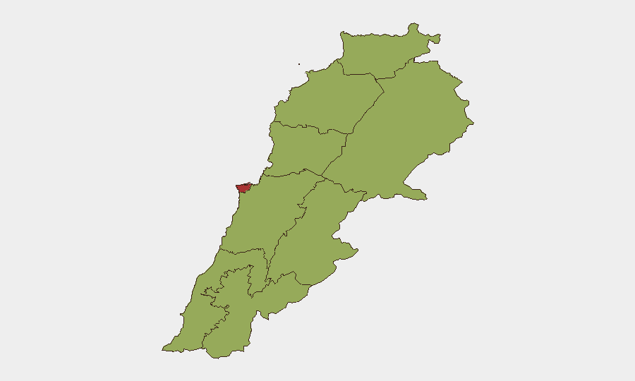
Lebanon remains at composite threat rank #21 globally (score 68) with Beirut Governorate significantly elevated at risk 77.7, driven by active Israeli-Lebanese military friction along the southern border and internal political instability. The past 72 hours have seen continued Israeli ground incursions, artillery strikes, and drone operations in southern governorates—particularly Nabatieh and Marjayoun—alongside Lebanese Army deployment in a US-mediated pilot zone. While no major escalation to nationwide conflict has materialized, the frequency of unconventional violence events and arrest/detention signals suggest sustained operational tempo and political tension with no clear de-escalation pathway.
Key Developments
- Zawtar al-Gharbiyeh, Nabatieh Governorate (~23–24 July): Lebanese Army units conducting second day of deployment under US-mediated framework agreement reported Israeli forces opening fire near their positions, creating direct risk to uniformed personnel in the designated pilot zone.
- Ali al-Taher hill & Nabatieh al-Fawqa (~23–24 July): Israeli artillery intermittently shelled Ali al-Taher and a drone strike hit Nabatieh al-Fawqa, confirming active aerial and indirect-fire operations affecting the Nabatieh area within the last 48 hours.
- Burj al-Muluk, Marjayoun District (~23–24 July): Israeli forces advanced to town outskirts, conducted home raid, confiscated civilian passport and phone, then withdrew—indicating direct civilian contact and intelligence-gathering activity in populated border zone.
- Sarbin, Marjayoun (~23–24 July): Israeli ground incursion coincided with heavy machine-gun fire; Lebanese National News Agency confirmed active small-arms engagement in this border town within the last 48 hours.
- Baraachit & Hadatha, Bint Jbeil District (~23–24 July): Overnight explosions reported in both towns, suggesting recent demolition or strike activity targeting civilian infrastructure in southern Lebanon.
- Multiple southern strikes (~20–24 July): Israeli operations broke a three-day pause, killing at least two civilians and sustaining operational activity throughout the reporting window amid ongoing buffer-zone negotiations.
Highest-Risk Areas
Beirut Governorate (77.7) dominates the risk landscape due to concentration of government, financial, and diplomatic infrastructure alongside political volatility and unconventional-violence signals. The southern governorates—Nabatieh (48.8), South (47.7), and Beqaa (47.7)—form a secondary risk tier driven by Israeli ground and aerial operations, Lebanese Army deployment, and proximity to the active conflict zone. Keserwan-Jbeil, Mount Lebanon, Akkar, Baalbek-Hermel, and North Governorate all register at 47.7, indicating baseline elevation across most of the country beyond the capital; this broad regional elevation reflects both spillover risk from southern military activity and internal state-stability concerns unrelated to border friction.
How GeoBit Would Assist
Organizations with personnel or assets in Lebanon should deploy AOI Monitoring & Early Warning with persistent focus on Nabatieh, Marjayoun, and Beirut to capture strike activity and movement patterns in real time. Conflict & Military mapping combined with GIS & Spatial Analysis enables security teams to identify safe corridors, track Israeli and Lebanese force positions, and model risk to specific facilities or travel routes. Multi-language OSINT fusion (combining Lebanese, Israeli, and international sources) and sentiment & temporal analysis of social media and local news will surface emerging threats—such as ceasefire collapse or political arrest waves—before they peak.
7-Day Outlook
Israeli operations in southern Lebanon are expected to continue at current intensity (ground incursions, artillery, drone strikes) as long as US-mediated negotiations remain stalled on buffer-zone depth and Army deployment timing. Internal Lebanese political signals (arrest/detain events, Beirut-level disapproval) suggest risk of domestic instability or leadership crises within 7–14 days. No indicators of major escalation to nationwide conflict or regional widening are present, but cumulative friction could trigger rapid deterioration if a significant casualty event occurs or negotiations formally collapse.
Highest-Risk Areas — Ranked
| # | State / Region | Risk |
|---|---|---|
| 1 | Beirut Governorate | 77.7 |
| 2 | Nabatieh Governorate | 48.8 |
| 3 | North Governorate | 47.7 |
| 4 | Akkar Governorate | 47.7 |
| 5 | Keserwan-Jbeil Governorate | 47.7 |
| 6 | Mount Lebanon Governorate | 47.7 |
| 7 | South Governorate | 47.7 |
| 8 | Beqaa Governorate | 47.7 |
| 9 | Baalbek-Hermel Governorate | 47.7 |
Sources
Previous Daily Briefs
A new Lebanon brief is written every day — each with its own risk map and downloadable CSV. Here's the last week; use the calendar to go further back.
📅 Browse every day by calendar →
Highlighted days have a brief. Tap a day for that day's map & analysis, or “csv” for that day's dataset ($5).
Atlas — our AI intelligence desk — emails them this snapshot personally. Nothing else, no list.