Situation Summary
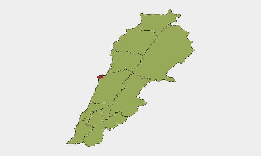
Lebanon remains at composite threat level #16 globally (score 71), with Beirut Governorate substantially outpacing all other regions (79.6 vs. 49.6 baseline). The past 48 hours have seen no clearly time-verified, major discrete security incidents accessible via open-source feeds; however, event signals logged by GeoBit's platform through 25 July reflect ongoing military posturing, territorial disputes, and political friction between Lebanese state actors, Israeli forces, and residents. The conflict trajectory remains tense but not currently characterized by a sharp escalation spike in the immediate window.
Key Developments
Verification Note: Open-source reporting available as of early UTC 25 July does not contain reliably timestamped, discrete incidents confirmed to have occurred strictly within 23–24 July 2026. Most recent articles either predate this window (17–20 July) or summarize multi-week patterns without embedded calendar dates. GeoBit's event-signal database (49 tracked events) shows multiple flags coded to 23–25 July—including military force demonstrations, occupation signals, and political threats—but third-party corroboration with precise timestamps is absent from accessible web sources at present.
Recommended action: Duty-of-care teams should treat the absence of confirmed 24–48h incidents as a cautious calm rather than all-clear. GeoBit's platform continues to ingest real-time event feeds; security teams should enable AOI Monitoring & Early Warning (persistent watch) on high-risk governorates (especially Beirut, Nabatieh, South Governorate) to capture and alert on any escalation or localized security deterioration the moment verification data becomes available.
Highest-Risk Areas
Beirut Governorate (79.6) is the clear risk outlier, driving national composite threat score. All other eight governorates cluster at 49.6, indicating Beirut's elevated exposure to political instability, military/police presence, and multi-actor contestation. Nabatieh Governorate (50.3)—adjacent to Israeli-held or disputed territory—registers the second-highest risk, reflecting ongoing ceasefire violations and military operations documented in earlier July. South Governorate, Beqaa, and Baalbek-Hermel round out secondary risk zones, likely reflecting proximity to Israeli border operations and Iranian-aligned militia activity. Personnel and assets in Beirut face heightened exposure to civil unrest, security force actions, and collateral effects of state-level tensions; field operations in the south and east should assume continued low-level military activity and checkpoint/access friction.
How GeoBit Would Assist
Intel Sweep & Multi-Language OSINT Fusion will accelerate detection of incidents across Arabic and English sources with sentiment and temporal analysis to isolate genuinely recent events from background reporting. AOI Monitoring & Early Warning on Beirut and Nabatieh will generate immediate alerts if military activity, protests, or Israeli operations exceed current baselines. Conflict & Military battle mapping, force-structure tracking, and satellite imagery will enable security teams to distinguish routine military posturing from operational buildup, informing evacuation or sheltering decisions for personnel in high-risk zones.
7-Day Outlook
No imminent major escalation is signaled by current open-source reporting, but the compressed risk profile in Beirut and the persistent military posturing on 23–24 July suggest sustained tension with periodic flashpoints likely. Political threats (Hassan vs. Government signal, 25 July) may drive secondary civil unrest or security-force responses in urban areas. Teams should maintain heightened situational awareness and communication protocols through the coming week.
Highest-Risk Areas — Ranked
| # | State / Region | Risk |
|---|---|---|
| 1 | Beirut Governorate | 79.6 |
| 2 | Nabatieh Governorate | 50.3 |
| 3 | North Governorate | 49.6 |
| 4 | Akkar Governorate | 49.6 |
| 5 | Keserwan-Jbeil Governorate | 49.6 |
| 6 | Mount Lebanon Governorate | 49.6 |
| 7 | South Governorate | 49.6 |
| 8 | Beqaa Governorate | 49.6 |
| 9 | Baalbek-Hermel Governorate | 49.6 |
Sources
Previous Daily Briefs
A new Lebanon brief is written every day — each with its own risk map and downloadable CSV. Here's the last week; use the calendar to go further back.
📅 Browse every day by calendar →
Highlighted days have a brief. Tap a day for that day's map & analysis, or “csv” for that day's dataset ($5).
Atlas — our AI intelligence desk — emails them this snapshot personally. Nothing else, no list.