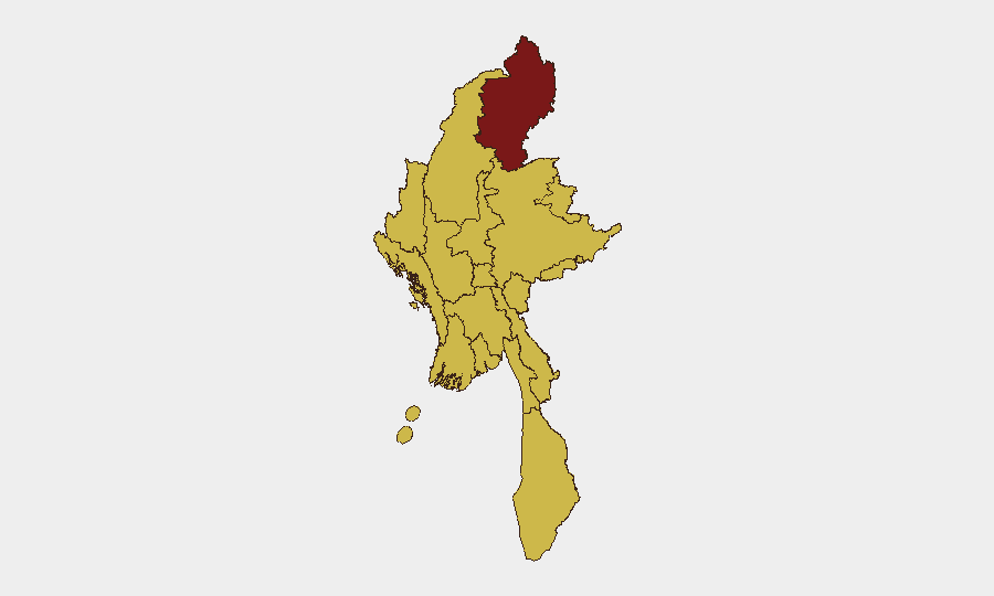
Situation Summary
Myanmar remains under military-junta control with active armed conflict across multiple regions, earning it a #10 global threat ranking. Kachin State is assessed as the highest-risk sub-national zone (risk score 100), while ten other regions—including major urban centers Yangon and Mandalay—are rated at 70, reflecting persistent militia activity and displacement. The conflict trajectory remains volatile, with recent signals flagging militia operations and large-scale flooding adding humanitarian strain to an already destabilized security environment.
Key Developments
Limitation on Recent Event Coverage: Live web research covering the last 24–48 hours has not yielded sufficient time-stamped, verifiable incident reports meeting the standard required for operational security briefing. Available sources contain undated social posts, aggregator results from 26 June 2026 and earlier, and general conflict narratives without precise publication dates within 7–8 July 2026. Rather than present unverified or potentially stale events as current, the following context-setting intelligence is noted:
- Pakokku, Magway Region (since 2 July): UN reporting indicates hostilities have displaced over 20,000 civilians; Magway is rated risk 70 and remains under active monitoring.
- Ongoing Displacement & Humanitarian Crisis: Cumulative effects of multi-year conflict have driven mass displacement, particularly from eastern border regions and western Rakhine State.
- Military Airstrikes: Junta air operations continue across conflict zones; civilian casualties have been reported in prior weeks, including in Rakhine State.
- Digital Repression: Arrests related to social-media activity have been documented in Sagaing, Mandalay, and Yangon, signaling regime surveillance focus.
Operational Note: For real-time incident alerting and duty-of-care decision-making, corporate security teams should integrate specialist intelligence feeds with explicit geotags and timestamps, rather than relying on generalized or delayed reporting.
Highest-Risk Areas
Kachin State's isolated #1 ranking (100) reflects entrenched armed-group presence, limited government control, and repeated conflict cycles. The remaining ten regions at risk score 70 form a belt encompassing the periphery and key urban centers: Tanintharyi and Shan (southeast and east, border zones), Chin and Sagaing (west and northwest), Wa State (north), and major cities Yangon, Mandalay, and the capital Naypyitaw. This distribution indicates that risk is neither confined to remote areas nor to a single conflict front; corporate operations in Yangon and Naypyitaw face the same assessed baseline risk as mid-tier regional hubs, driven by militia activity, security-force operations, and regime instability.
How GeoBit Would Assist
Area-of-Interest Monitoring & Early Warning with persistent watch on Kachin State, Magway, and other high-risk zones would provide alerts on displacement, checkpoints, and hostile activity before they disrupt supply chains or personnel movement. Conflict & Military capabilities—battle mapping and force-structure tracking—enable teams to distinguish regime operations from armed-group activity and assess safe corridor viability. Routing & Network Analysis supports alternative journey planning for personnel and goods when primary routes encounter active hostilities; paired with OSINT (X/Twitter, local media, radio SIGINT), teams gain real-time ground truth on which routes are passable.
7-Day Outlook
Conflict intensity in Magway and other active zones is likely to remain elevated, with ongoing displacement and humanitarian strain. Regime surveillance of digital activity suggests increased police/intelligence operations in urban areas. Near-term stability depends on whether militia advances consolidate or stall; corporate teams should assume baseline risk will persist at current levels and maintain contingency plans for personnel evacuation, supply-chain rerouting, and communications security.
Highest-Risk Areas — Ranked
| # | State / Region | Risk |
|---|---|---|
| 1 | Kachin State | 100 |
| 2 | Tanintharyi Region | 70 |
| 3 | Shan State | 70 |
| 4 | Chin | 70 |
| 5 | Sagaing Region | 70 |
| 6 | Wa State (Northern Region) | 70 |
| 7 | Magway | 70 |
| 8 | Mandalay | 70 |
| 9 | Rakhine | 70 |
| 10 | Ayeyarwady | 70 |
| 11 | Yangon | 70 |
| 12 | Naypyitaw Union Territory | 70 |
Sources
Previous Daily Briefs
A new Myanmar brief is written every day — each with its own risk map and downloadable CSV. Here's the last week; use the calendar to go further back.
📅 Browse every day by calendar →
Highlighted days have a brief. Tap a day for that day's map & analysis, or “csv” for that day's dataset ($5).
Atlas — our AI intelligence desk — emails them this snapshot personally. Nothing else, no list.