Situation Summary
Niger maintains a composite threat ranking of #27 globally with a threat score of 80, reflecting persistent multi-domain instability across northern and eastern regions. Recent signal activity (13–14 July) indicates elevated conventional military operations and cross-border force movements, though open-source incident confirmation for the past 24–48 hours remains limited. The security environment is characterized by active counter-terrorism and law-enforcement operations, regional military activity involving neighboring states, and documented kidnapping threats, but no discrete, time-stamped attacks, protests, or infrastructure disruptions have been independently corroborated within Niger during the immediate reporting window.
Key Developments
- Regional Military Activity (13–14 July): Signal data reflects conventional military force movements and operations involving Niger, Chad, Nigeria, and Cameroon during 13–14 July, indicating cross-border tension and active military posture. Specific incident details and locations remain unconfirmed in open-source reporting.
- Intelligence-Terrorist Public Statements (13 July): Government and intelligence agency public statements on 13 July reference terrorist activity, though corroborated incident details are not yet available in independent multi-source reporting.
- Civilian Abduction Threat (13 July): Signals indicate an abduction/hostage event involving a student and cross-border Nigerian actors on 13 July; details and victim status require confirmation through secondary sources.
- Law-Enforcement Detention Activity (14 July): An arrest/detention incident involving village-level actors and Niger authorities was flagged on 14 July; context and specifics are not yet independently confirmed.
- No Confirmed Discrete Incidents (Past 48 Hours): Multi-source open-source monitoring, regional media, and diplomatic advisory feeds have not yielded independently corroborated, time-specific attacks, kidnappings, or civil unrest within Niger during the 24–48 hours preceding this brief. Active security operations continue, but incident details do not meet publication thresholds.
Highest-Risk Areas
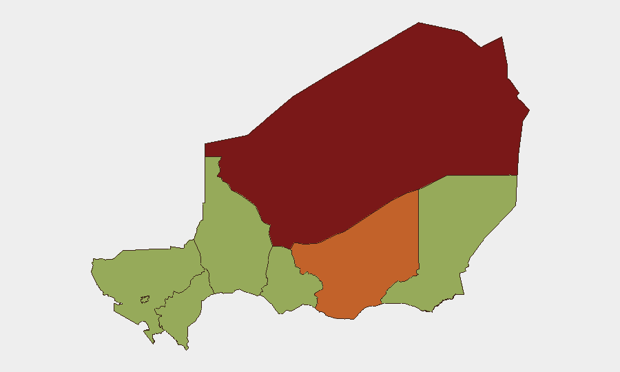
Agadez Region (86.1) dominates sub-national risk and remains the primary driver of Niger's national threat score, driven by ongoing counter-terrorism operations, trafficking networks, and historical militant activity in the central Sahara. Zinder Region (75.0) follows as a secondary hotspot, with Diffa, Tillabéri, Niamey, Tahoua, Dosso, and Maradi regions all registering moderate-to-elevated risk (56.1). The concentration of highest risk in the north and east reflects persistent transnational militant presence, resource scarcity, cross-border instability with Nigeria and Libya, and limited state capacity in remote areas. Niamey's inclusion at moderate risk reflects political-stability concerns and infrastructure vulnerability tied to recent government and military transitions.
How GeoBit Would Assist
Security teams operating in Niger should employ Intel Sweep and global event feeds to monitor real-time signal activity and cross-border military movements, paired with OSINT fusion and corroboration to distinguish confirmed incidents from unvalidated signal noise. AOI Monitoring & Early Warning with persistent area-of-interest watch over Agadez and Zinder regions provides actionable alerting on emerging threats to personnel and assets. Battle mapping and force-structure tracking help teams understand military operations and positioning, while alternative route and journey planning support duty-of-care protocols for staff movement in high-risk regions.
7-Day Outlook
Cross-border military activity is likely to persist, particularly involving Niger-Chad-Nigeria border zones. Agadez and Zinder regions will remain under elevated threat from militant and criminal networks. No major escalation or national-level political crisis is currently signaled, but kidnapping and law-enforcement detention risks warrant continued monitoring and staff security protocols in remote and northern areas.
Highest-Risk Areas — Ranked
| # | State / Region | Risk |
|---|---|---|
| 1 | Agadez Region | 86.1 |
| 2 | Zinder Region | 75 |
| 3 | Diffa Region | 56.1 |
| 4 | Tillabéri Region | 56.1 |
| 5 | Niamey | 56.1 |
| 6 | Tahoua Region | 56.1 |
| 7 | Dosso Region | 56.1 |
| 8 | Maradi Region | 56.1 |
Sources
Previous Daily Briefs
A new Niger brief is written every day — each with its own risk map and downloadable CSV. Here's the last week; use the calendar to go further back.
📅 Browse every day by calendar →
Highlighted days have a brief. Tap a day for that day's map & analysis, or “csv” for that day's dataset ($5).
Atlas — our AI intelligence desk — emails them this snapshot personally. Nothing else, no list.