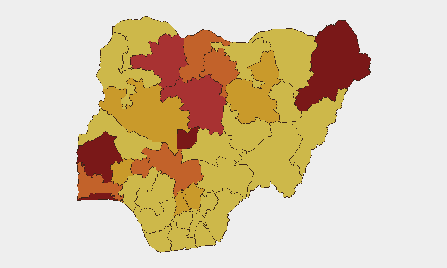
Situation Summary
Nigeria remains the second-highest-threat country globally, with 766 tracked security events driven primarily by active insurgency, kidnapping networks, and communal violence. The last 24–48 hours have seen a sharp spike in abductions, mass casualty attacks in rural communities, and coordinated police operations that suggest both operational tempo and institutional response are intensifying. President Tinubu convened an emergency security meeting on 14 July following escalating banditry and hostage-taking, signaling political acknowledgment of critical trajectory risk. Without sustained disruption of armed group mobility and kidnapping supply chains, civilian casualty rates and displacement are likely to accelerate through mid-2026.
Key Developments
- Otukpo LGA, Benue State (13 Jul): Eight people killed in a suspected terrorist attack using guerrilla tactics; attackers fled into nearby forests, indicating sustained operational capacity in Middle Belt communities.
- Benue and Plateau states (13 Jul): Separate coordinated attacks resulted in 27 deaths total—18 in Benue, nine members of a single family in Plateau—suggesting sustained multi-node targeting or copycat violence.
- Oyo State, Oriire district (13 Jul): Nigerian security forces rescued 39 schoolchildren and six teachers abducted nearly two months prior; one teacher died in captivity, underscoring risks to educational facilities and the timeline-compression problem in hostage cases.
- Nationwide coordinated police sweep (within last 24h): Nigeria Police Force arrested 43 suspects and rescued six kidnap victims across 11 states (Anambra, Bayelsa, Benue, Delta, Gombe, Nasarawa, Niger, Ogun, Osun, Bauchi, Zamfara), indicating multi-state criminal networks and synchronized law enforcement response.
- Northern border region intelligence (13–14 Jul): Armed groups are relocating under military pressure in Zamfara/Kaduna/Katsina border areas, with increased kidnapping threats, mob justice, and illegal oil-refining activity in newly contested zones—a displacement signal that may shift risk geography.
- Abuja, Nnamdi Azikiwe International Airport (14 Jul): NDLEA intercepted a South African national for suspected drug trafficking, consistent with ongoing transnational organized-crime activity at key transportation nodes.
- Ogbomoso, Oyo State (14 Jul): Police detained Prince Adeniyi Adeyemi and relatives in a fraud probe involving a purported fake government agency, signaling financial-crime and elite-complicity dimensions.
Highest-Risk Areas
Oyo State ranks as Nigeria's single highest-risk jurisdiction (score 100), with Lagos State (89) and Borno State (81.7) following closely. The top 12 highest-risk states cluster across three regions: the Southwest (Oyo, Lagos, Ekiti, Ogun, Osun), the North-Central (FCT, Kaduna, Kogi), and the Northeast (Borno, Katsina, Zamfara, Kano). Recent kidnappings in Oyo and ongoing terror-group repositioning in the North-Central/Northern border zones explain the concentration; FCT and Kaduna remain critical because they host federal administration, commercial hubs, and major transport corridors. Borno's ranking reflects Boko Haram–affiliated activity, while Zamfara and Katsina are primary bandit strongholds undergoing tactical displacement.
How GeoBit Would Assist
Security teams should deploy AOI Monitoring & Early Warning on identified bandit-relocation zones (Zamfara/Kaduna/Katsina borders) and educational facilities in high-risk states to receive real-time alerting on group movement and kidnapping signals. Conflict & Military mapping combined with Network & Actor Analysis will track armed-group force structure and supply-chain interdiction points. Intel Sweep and multi-language OSINT fusion across social media, messaging platforms, and local reporting will identify emerging kidnapping targets and ransom networks before incidents escalate.
7-Day Outlook
Security incidents will likely remain elevated through late July as armed groups consolidate in newly contested areas and respond to police/military pressure through increased hostage-taking for ransom. Educational facilities and rural communities in Oyo, Benue, and the northern border zone face compounded risk. Coordination between federal and state security agencies is improving operationally, but recruitment and supply-line disruption remain the critical vulnerability.
Highest-Risk Areas — Ranked
| # | State / Region | Risk |
|---|---|---|
| 1 | Oyo State | 100 |
| 2 | Lagos State | 89 |
| 3 | Borno State | 81.7 |
| 4 | Federal Capital Territory | 81.7 |
| 5 | Kaduna State | 79.5 |
| 6 | Zamfara State | 78.9 |
| 7 | Ekiti State | 75.6 |
| 8 | Ogun State | 74.7 |
| 9 | Katsina State | 74.4 |
| 10 | Kogi State | 74.1 |
| 11 | Kano State | 73.7 |
| 12 | Osun State | 72.7 |
Sources
Previous Daily Briefs
A new Nigeria brief is written every day — each with its own risk map and downloadable CSV. Here's the last week; use the calendar to go further back.
📅 Browse every day by calendar →
Highlighted days have a brief. Tap a day for that day's map & analysis, or “csv” for that day's dataset ($5).
Atlas — our AI intelligence desk — emails them this snapshot personally. Nothing else, no list.