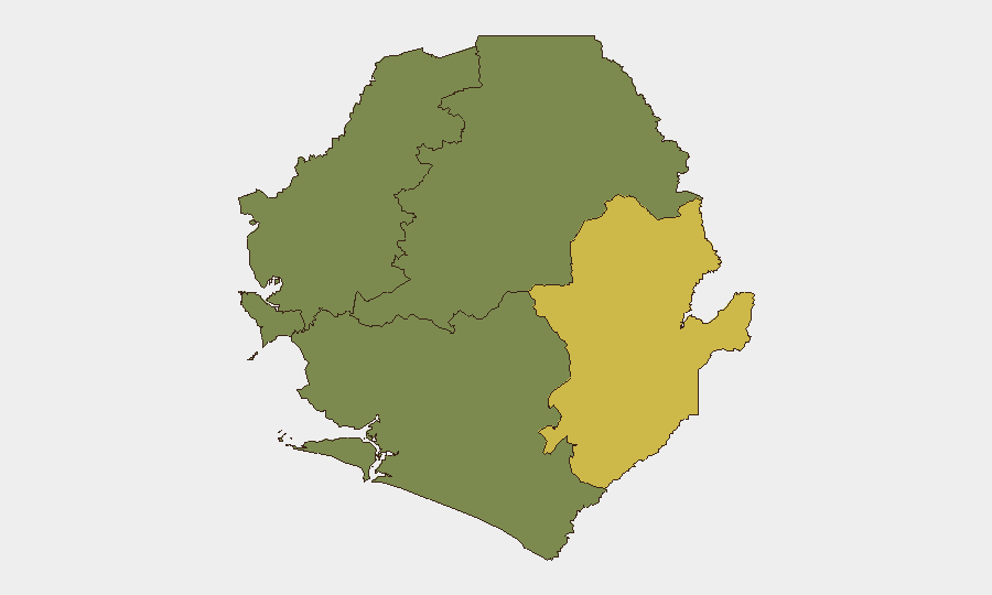
Situation Summary
Sierra Leone remains a low-intensity security environment (global rank #116, composite threat score 9), with no tracked active conflict or organized insurgency. The dominant near-term risk is environmental and infrastructure-related, following severe flooding in Freetown on 5 August that killed three people and displaced hundreds. Secondary concerns include localized crime activity and civil-infrastructure fragility, concentrated in the Western Area and Eastern Province.
Key Developments
- Freetown, Calaba Town / K. Step, Alpha Terrace (9 Aug 2026) — Residential building collapse and flooding during heavy rains reported by Sierra Leone Monitor; indicates ongoing civil-safety hazard in the capital following the 5 August flood event.
- Mamamah, Western Area Rural District (9 Aug 2026) — Police arrested a suspected drug dealer (Kush) following a community tip; arrest reported by Sierra Leone Monitor and social channels, suggesting continued low-level narcotics activity in rural Western Area.
- Lumley / Regent Road, western Freetown (recent, within 48h) — Social reporting indicates a major fire destroyed the Jes-Ka-Mac 1 Entertainment Complex; report unconfirmed by independent news outlet and requires verification.
- Brookfields, Freetown (recent, within 48h) — Old Railway Line Bridge closure ordered due to safety concerns; reported by Expo Times and reflects broader infrastructure fragility in the capital.
- Freetown (ongoing since 5 Aug 2026) — Post-flood civil-safety risks include standing water, contamination, and structural damage; secondary displacement and disease risk remains elevated in low-income urban areas.
Highest-Risk Areas
Eastern Province (risk score 68) is the highest-risk administrative region, driven by geographic remoteness, limited state presence, and historical trafficking vulnerabilities. Western Area (risk score 35) poses the second-highest risk, concentrated in Freetown and peri-urban zones; current drivers include flood-related infrastructure collapse, overcrowded informal settlements, and localized crime. Northern and Southern provinces show minimal tracked risk (score 0), suggesting either lower underlying threat density or limited reporting coverage. The concentration of risk in the Western Area—where the capital and primary economic nodes are located—elevates duty-of-care exposure for organizations with personnel or assets in Freetown.
How GeoBit Would Assist
Organizations operating in Sierra Leone should deploy AOI Monitoring & Early Warning on Freetown and the Western Area Rural District to track post-flood civil-safety developments, infrastructure damage, and displacement in real time. OSINT Fusion & Corroboration (X/Twitter, Telegram, local news outlets, and social channels) would filter verified incident reporting from unconfirmed rumors, reducing false-positive alert fatigue. GIS & Spatial Analysis combined with satellite imagery review would map flood-affected infrastructure and identify high-risk zones (informal settlements, degraded bridges, water-management areas) to inform personnel movement and asset-security planning.
7-Day Outlook
Flood-related risks will likely persist for 5–7 days as drainage, contamination, and secondary structural failures are addressed. Heavy-rain probability and additional localized flooding remain elevated during West African rainy-season conditions (June–October). No significant escalation in organized crime, civil unrest, or security-force activity is expected in the near term; the security environment is expected to remain below baseline, contingent on post-disaster coordination effectiveness.
Highest-Risk Areas — Ranked
| # | State / Region | Risk |
|---|---|---|
| 1 | Eastern Province | 68 |
| 2 | Western Area | 35 |
| 3 | North West Province, Sierra Leone | 0 |
| 4 | Northern Province, Sierra Leone | 0 |
| 5 | Southern Province, Sierra Leone | 0 |
Sources
- sierraleonemonitor.com
- expomediasl.com
- thesierraleonetelegraph.com
- voiceofsalonenewspaper.com
- sierraleonemonitor.com
- sierraleonemonitor.com
- cocorioko.net
- thesierraleonetelegraph.com
- t.me
- sierraleonemonitor.com
- forumnews-sl.com
- nationalistsl.com
- auswaertiges-amt.de
- mail.ceoafrica.com
- premiermedia-sl.com
- moice.gov.sl
- sierraloaded.sl
- smartraveller.gov.au
Previous Daily Briefs
A new Sierra Leone brief is written every day — each with its own risk map and downloadable CSV. Here's the last week; use the calendar to go further back.
📅 Browse every day by calendar →
Highlighted days have a brief. Tap a day for that day's map & analysis, or “csv” for that day's dataset ($5).
Atlas — our AI intelligence desk — emails them this snapshot personally. Nothing else, no list.