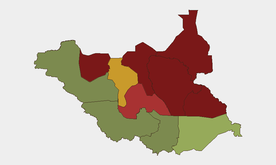
Situation Summary
South Sudan remains in active conflict, ranking #29 globally on composite threat, with ongoing armed confrontations between SSPDF and SPLA-IO factions alongside communal violence, banditry, and civilian targeting. The security environment shows no signs of de-escalation; insecurity is worsening in key northern and central regions and continues to disrupt humanitarian access and civilian movement. No major new incidents have been independently verified in the last 24–48 hours, though the baseline threat from armed clashes, abductions, and roadside violence persists across the country.
Key Developments
- Mundri–Juba road (Central Equatoria) — 2026-08-05 — Two mourners killed and four injured in an ambush; illustrates ongoing risk on major transport corridors despite relatively lower state-level risk ranking.
- Longamere Boma (Lakes State) — 2026-08-05 — Pastor and several young men abducted; property seized. Pattern consistent with kidnapping-for-ransom and militia predation in high-risk pastoral areas.
- Jurwach checkpoint (Jonglei State) — 2026-07-27 — Nine boat passengers killed at checkpoint; reflects checkpoint-based extortion and violence affecting water-based movement in conflict zones.
- Jonglei, Upper Nile, and Unity states — 2026-08-08 to 2026-08-10 (reporting context) — UN reports document ongoing SSPDF–SPLA-IO armed confrontations and escalating tensions; no discrete new incident independently verified in the last 48 hours, but sustained factional clashes remain the primary driver of northern instability.
- No new confirmed incidents in final 24–48 hours — As of 2026-08-10 reporting window, no independently corroborated discrete security event has been flagged for the most recent 24–48 hours; baseline threat remains elevated but situational change is currently unconfirmed.
Highest-Risk Areas
Unity and Jonglei states dominate the sub-national ranking (95 and 93 respectively), followed by Upper Nile (88) and Greater Pibor Administrative Area (87). These northern and central regions are epicenters of factional armed conflict, cattle raiding, and militia activity; their composite scores reflect both frequency and severity of violence, as well as limited state capacity and humanitarian access. In contrast, Western Equatoria (38) and Central Equatoria (35) show markedly lower risk, though the recent ambush on the Mundri–Juba road indicates that even lower-ranked zones remain vulnerable to banditry and intercommunal flare-ups. Corporate personnel and logistics should calibrate movement planning and duty-of-care protocols according to these sub-national gradients.
How GeoBit Would Assist
Teams managing South Sudan exposure should deploy AOI Monitoring & Early Warning on high-risk states (Unity, Jonglei, Upper Nile) to detect emerging clashes or displacement; Routing & Network Analysis to identify safer transit alternatives to conflict-affected corridors; and Intel Sweep with multi-language OSINT and X/Telegram feeds to catch militia announcements, checkpoint warnings, and real-time incident chatter before incidents affect operations. Conflict & Military force-structure tracking and Network & Actor Analysis provide context on factional positioning and leadership changes that may signal tactical shifts or negotiation windows.
7-Day Outlook
Factional tensions in the north are likely to persist at current intensity without major new clashes or ceasefires visible in near-term indicators. Banditry, abductions, and checkpoint violence on secondary roads and waterways will remain routine; the main operational risk lies in route-dependent movement and delayed early warning on roadblock formation. No significant deescalation is anticipated in the next 7 days.
Highest-Risk Areas — Ranked
| # | State / Region | Risk |
|---|---|---|
| 1 | Unity | 95 |
| 2 | Jonglei | 93 |
| 3 | Upper Nile | 88 |
| 4 | Greater Pibor Administrative Area | 87 |
| 5 | Northern Bahr el Ghazal | 82 |
| 6 | Lakes | 78 |
| 7 | Warrap | 72 |
| 8 | Ruweng Administrative Area | 68 |
| 9 | Eastern Equatoria | 52 |
| 10 | Western Equatoria | 38 |
| 11 | Central Equatoria | 35 |
| 12 | Western Bahr el Ghazal State | 28 |
Sources
Previous Daily Briefs
A new South Sudan brief is written every day — each with its own risk map and downloadable CSV. Here's the last week; use the calendar to go further back.
📅 Browse every day by calendar →
Highlighted days have a brief. Tap a day for that day's map & analysis, or “csv” for that day's dataset ($5).
Atlas — our AI intelligence desk — emails them this snapshot personally. Nothing else, no list.