Situation Summary
Sudan remains in acute civil war with composite threat score of 97 (global rank #4), characterized by multi-front conventional and drone warfare, mass-atrocity warnings from US and UN, and proliferating foreign military support. The past 48 hours show sustained high-intensity combat across North Kordofan, South Kordofan, Darfur, and White Nile State, with concurrent criminal and tribal violence in peripheral areas. New EU and UK sanctions on gold trade and financial networks signal tightening international pressure but also risk destabilizing informal economies and fueling armed groups' shift to alternative revenue. Trajectory remains deteriorating, with RSF/allied encirclement of El-Obeid and drone-strike escalation indicating risk of mass atrocities within days to weeks.
Key Developments
- El-Obeid, North Kordofan (July 20–21): US State Department and UN Security Council issued imminent mass-atrocity warnings as RSF and allied forces mass and encircle the city. Drone strikes continue in and around El-Obeid; UN verified lethal strikes in June and warned of deadlier phase ahead. El-Obeid remains Sudan's highest single-location concern for corporate security.
- Al-Qardoud village, South Kordofan (July 19): Heavy artillery and clashes reported, with hundreds of civilians fleeing; described as fresh escalation on a key front line, driving displacement and humanitarian access degradation.
- Western Kordofan and White Nile (July 16–19): Multi-day high-casualty strikes reported: 57 killed Friday, 10 Saturday in Western Kordofan; 40 killed prior day same region; 17 civilians killed Wednesday in White Nile State. Pattern indicates rapidly shifting violence affecting overland transport corridors.
- Sari, North Darfur (July 17): Suspected army drone strike killed at least 4 civilians, ~100 km northeast of El Fasher. Consistent with broader drone-use-against-civilians pattern flagged by UN.
- Al-Dabba, Northern State (July 18–20): Tribal-military clashes and gang violence killed at least 8–11 people; police reinforcements deployed. Highlights persistent communal violence on main Nile corridor.
- Al-Rahad, North Kordofan (July 17): Armed man affiliated with pro-army militia opened fire, killing 4 and injuring 7. Reflects localized weapons proliferation and militia fragmentation.
- EU/UK Sanctions (effective July 15 onward, highlighted July 18–21): EU prohibits purchase/import of Sudanese gold and export of mercury/cyanide to Sudan. UK sanctioned 11 entities/individuals providing money, weapons, and gold revenue to armed groups. Immediate impact on gold-mining regions and trade routes; implications for mining-sector logistics and informal finance.
Highest-Risk Areas
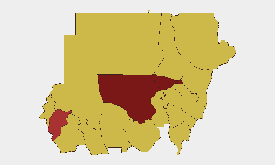
North Kordofan State (risk 97.9) dominates the threat landscape, driven by RSF/allied encirclement of El-Obeid and drone-strike intensity. Al Khartum (81) and Central Darfur (79.1) reflect capital-area instability and ongoing Darfur-wide combat. A secondary tier—River Nile, Northern, Blue Nile, and eastern states (risk 67.9–69.8)—faces conventional military operations, criminal violence, and displacement pressures. Gold-mining regions across River Nile, Darfur, and Northern State now face compounded risk from sanctions-driven economic disruption and continued armed-group activity.
How GeoBit Would Assist
Corporate teams would deploy AOI Monitoring & Early Warning on El-Obeid, North Kordofan gold zones, and key transport corridors to catch drone-strike and military-movement signals before escalation. Battle Mapping and Force Structure analysis would track RSF/allied encirclement tactics and SAF repositioning to forecast pressure points. Routing & Network Analysis would identify safe overland and supply alternatives as main corridors degrade; Conflict & Military and Satellite & Imagery analysis would verify ground conditions and displacement flows.
7-Day Outlook
El-Obeid siege and mass-atrocity risk will likely intensify over the next 7–10 days, with potential for humanitarian collapse and large-scale civilian casualty events. Drone strikes and artillery will continue across Kordofan and Darfur; new sanctions disruption may accelerate criminal/militia fragmentation in peripheral states, raising kidnap and extortion risk. Personnel and supply chains in North Kordofan, Darfur, and White Nile should assume operational disruption and heightened kinetic threat through late July.
Highest-Risk Areas — Ranked
| # | State / Region | Risk |
|---|---|---|
| 1 | North Kordofan State | 97.9 |
| 2 | Al Khartum | 81 |
| 3 | Central Darfur State | 79.1 |
| 4 | River Nile State | 69.8 |
| 5 | Northern State | 69.8 |
| 6 | Blue Nile | 67.9 |
| 7 | Aj Jazira | 67.9 |
| 8 | Red Sea State | 67.9 |
| 9 | Al Qadarif State | 67.9 |
| 10 | Kassala State | 67.9 |
| 11 | Sennar State | 67.9 |
| 12 | South Darfur State | 67.9 |
Sources
Previous Daily Briefs
A new Sudan brief is written every day — each with its own risk map and downloadable CSV. Here's the last week; use the calendar to go further back.
📅 Browse every day by calendar →
Highlighted days have a brief. Tap a day for that day's map & analysis, or “csv” for that day's dataset ($5).
Atlas — our AI intelligence desk — emails them this snapshot personally. Nothing else, no list.