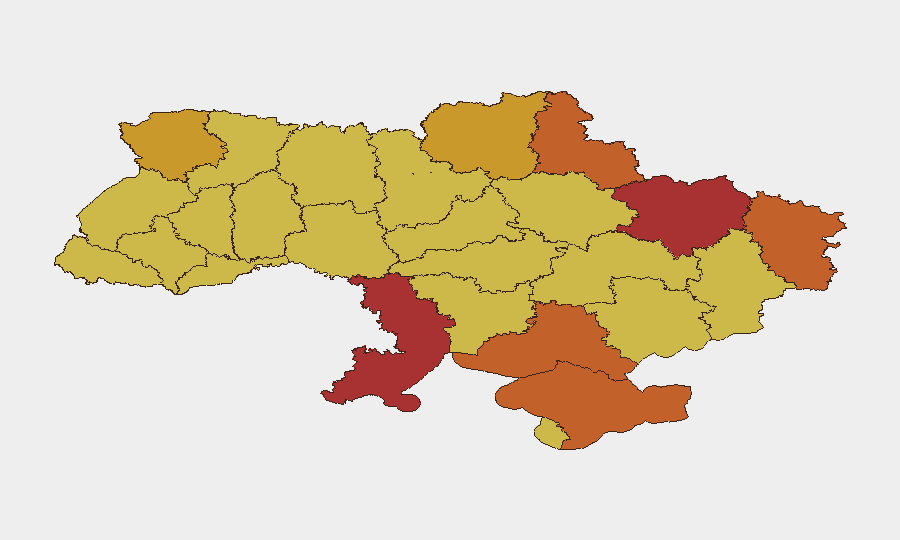
Situation Summary
Ukraine remains under sustained Russian aerial and conventional attack, with 1,937 tracked threat events as of 2026-08-03. The last 48 hours have witnessed a sharp intensification of strikes on civilian infrastructure across Kyiv, Kharkiv, Odesa, and Dnipropetrovsk oblasts, resulting in dozens of casualties and widespread damage to residential and transportation networks. Frontline intensity continues to drive elevated risk across eastern and southern operational zones, with no indication of de-escalation.
Key Developments
- Kyiv (2026-08-02): Ballistic missile and drone strikes killed at least 9 people and injured over 20; separate drone attack reported 3 killed and 10 injured, with fires across multiple districts and damage to civilian infrastructure.
- Kharkiv (Nemyshlianskyi district, 2026-08-02): Russian strike on five-story residential building caused civilian casualties and significant structural damage.
- Kryvyi Rih (Dnipropetrovsk Oblast, 2026-08-02): Russian missile attack on residential areas killed 4–6 civilians, including children reported among injured.
- Nikopol (Dnipropetrovsk Oblast, 2026-08-02): Drone attack on civilian bus injured 16 people, with 8 hospitalized and at least 3 in serious condition.
- Kharkiv (bus stop, 2026-08-02): Geran-3 (Shahed-type) UAV strike on bus stop and nine-story building injured at least 5 civilians.
- Odesa (2026-08-02): Ballistic missile strikes on civilian infrastructure killed 2, injured 1, and destroyed multiple vehicles; fire-control response successful.
- Frontline—Pokrovsk & Kostiantynivka (Donetsk Oblast, 2026-08-02): Around 150 clashes recorded in one day with heavy drone and guided bomb use; intense shelling of border areas.
Highest-Risk Areas
Kyiv (risk 100) and Odesa Oblast (78.4) face the most acute near-term threat due to sustained Russian precision strikes on civilian infrastructure and transport networks. Kharkiv and Sumy oblasts (78.3 and 75.1, respectively) remain under intense ground and aerial pressure along active frontlines. These four regions account for the majority of recent casualties and infrastructure damage. Risk across southern and eastern oblasts (Kherson, Luhansk, Dnipropetrovsk) remains elevated due to proximity to active military operations and ongoing shelling.
How GeoBit Would Assist
Security and risk teams should employ AOI Monitoring & Early Warning to track persistent threats in Kyiv, Kharkiv, and Odesa with real-time alerting on new strike activity. Intel Sweep and OSINT fusion capabilities enable rapid corroboration of claims from Ukrainian regional authorities and military statements, reducing false-positive risk in duty-of-care assessments. Routing & Network Analysis provides alternative journey planning to avoid high-impact zones and public transport hubs targeted in recent attacks, while Satellite & Imagery Analysis offers damage assessment and infrastructure-status updates to inform staffing decisions and asset relocation.
7-Day Outlook
Sustained Russian aerial bombardment is likely to continue across major urban centers and transport corridors through the coming week, with Kyiv and Kharkiv remaining primary targets. Ground operations along the Pokrovsk and Kostiantynivka directions are expected to maintain high intensity. Corporate personnel in these regions should anticipate continued air-raid alerts, infrastructure disruptions, and restricted movement.
Highest-Risk Areas — Ranked
| # | State / Region | Risk |
|---|---|---|
| 1 | Kyiv | 100 |
| 2 | Odesa Oblast | 78.4 |
| 3 | Kharkiv Oblast | 78.3 |
| 4 | Sumy Oblast | 75.1 |
| 5 | Kherson Oblast | 74 |
| 6 | Autonomous Republic of Crimea | 73.1 |
| 7 | Luhansk Oblast | 73 |
| 8 | Volyn Oblast | 72.2 |
| 9 | Chernihiv Oblast | 71.5 |
| 10 | Khmelnytskyi Oblast | 70.7 |
| 11 | Dnipropetrovsk Oblast | 70.5 |
| 12 | Zakarpattia Oblast | 70.1 |
Sources
Previous Daily Briefs
A new Ukraine brief is written every day — each with its own risk map and downloadable CSV. Here's the last week; use the calendar to go further back.
📅 Browse every day by calendar →
Highlighted days have a brief. Tap a day for that day's map & analysis, or “csv” for that day's dataset ($5).
Atlas — our AI intelligence desk — emails them this snapshot personally. Nothing else, no list.