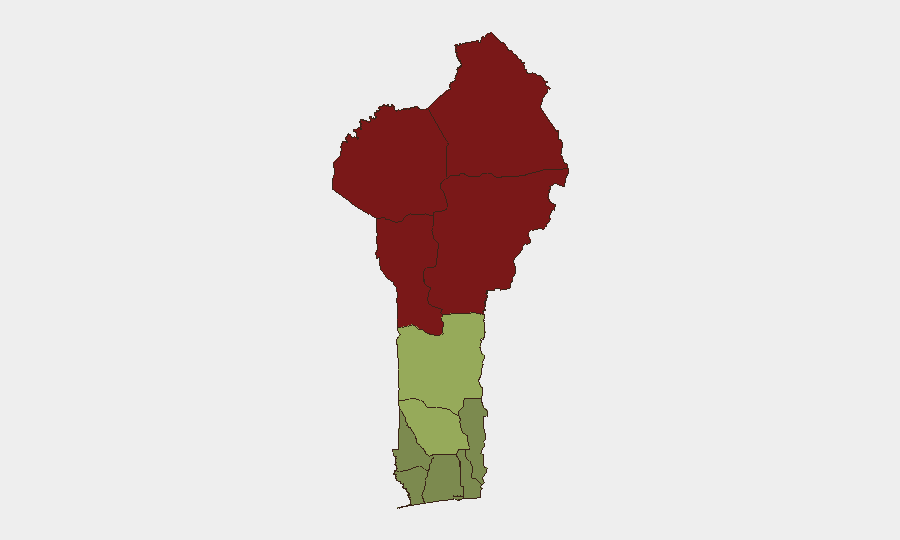
Situation Summary
Benin remains a #48 global threat priority (composite score 37), with insurgency and terrorism as the primary driver. No tracked security events have occurred within Benin's borders in the past 48 hours; however, a mass attack and kidnapping in adjacent Borgu, Niger State (Nigeria) on 2026-08-21 has generated documented refugee inflows into Benin's border zones. Routine law-enforcement operations in Cotonou (anti-narcotics sweeps, motorcycle-robbery dismantling) reflect active policing but no systemic deterioration in the capital.
Key Developments
- Borgu, Niger State (Nigeria)–Benin Border – Mass Attack with Cross-Border Spillover (2026-08-21, reported 2026-08-26): Armed group attacked multiple mosques in Dekara, Gidan Zana, and Sabon Gida during Friday prayers, killing 30–40 and abducting hundreds. Local authorities confirm that residents fled into neighbouring Benin to seek safety, creating documented refugee inflows into Benin's northern border areas.
- Cotonou, PK3 Market (Nouveau Missèbo) – Anti-Narcotics Operation (2026-08-22, reported 2026-08-24): Police arrested seven individuals for cannabis and psychotropic-tablet dealing; seizures of drugs and suspected proceeds indicate heightened enforcement in busy commercial zones.
- Cotonou, 5ᵉ Arrondissement Bus Terminal – Psychotropic-Trafficking Interdiction (2026-08-21, reported 2026-08-25): Two travelers arrested en route to Mali with 1,099 + 650 blister packs of classified psychotropic substances; ongoing investigation into regional supply chains.
- Pahou–Tori–Allada–Cotonou Corridor – Motorcycle-Robbery Gang Dismantled (by 2026-08-24): Police announced successful operation against organised property-crime network operating on southern routes; suspected receivers arrested in Cotonou.
- Thya Village, Angaradébou District, Kandi Municipality – Mob Violence (2026-08-19): Two men suspected of cattle theft summarily executed by angry mob; reflects localised vigilantism in Alibori Department.
Highest-Risk Areas
Alibori (92), Atakora (88), Donga (85), and Borgou (83) departments dominate the risk ranking and are driven primarily by proximity to Nigerian insurgent groups and porous border control. The mass casualty event in Borgu on 2026-08-21 underscores active spillover risk in Benin's northwestern corridor. Zou and Collines departments (45, 42 respectively) represent a secondary tier of concern. Southern coastal departments (Atlantique, Littoral, Ouémé) remain substantially lower-risk, though Cotonou experiences endemic organised crime (trafficking, robbery).
How GeoBit Would Assist
A security team operating in Benin should deploy AOI Monitoring & Early Warning capabilities on the Alibori, Atakora, Donga, and Borgou departments to track cross-border movement, armed-group activity, and refugee flows in near–real-time. Intel Sweep and multi-language OSINT (X/Twitter, Telegram, local news feeds) would provide early signals of trafficking networks, crime patterns, and potential security deterioration ahead of mainstream reporting. Routing & Network Analysis would enable identification of safer transit corridors in high-risk departments and contingency evacuation pathways from border zones.
7-Day Outlook
The influx of refugees from the Borgu attack may strain local resources and create secondary displacement in Benin's border departments over the next 7 days, with potential for strain on humanitarian access. Law-enforcement operations in Cotonou are likely to continue at current tempo; no escalation in organised crime or instability is evident. Northern departments remain the primary concern; any further cross-border armed activity or significant refugee surge should be monitored closely via persistent border-zone surveillance.
Highest-Risk Areas — Ranked
| # | State / Region | Risk |
|---|---|---|
| 1 | Alibori Department | 92 |
| 2 | Atakora Department | 88 |
| 3 | Donga Department | 85 |
| 4 | Borgou Department | 83 |
| 5 | Zou Department | 45 |
| 6 | Collines Department | 42 |
| 7 | Plateau Department | 38 |
| 8 | Kouffo Department | 35 |
| 9 | Mono Department | 32 |
| 10 | Atlantique Department | 28 |
| 11 | Littoral | 25 |
| 12 | Ouémé Department | 22 |
Sources
Previous Daily Briefs
A new Benin brief is written every day — each with its own risk map and downloadable CSV. Here's the last week; use the calendar to go further back.
- August 24, 2026
- August 22, 2026
- August 20, 2026
- August 18, 2026
- August 16, 2026
- August 14, 2026
- August 12, 2026
📅 Browse every day by calendar →
Highlighted days have a brief. Tap a day for that day's map & analysis, or “csv” for that day's dataset ($5).
Atlas — our AI intelligence desk — emails them this snapshot personally. Nothing else, no list.