Situation Summary
China remains at #17 globally (composite threat score 81) with 992 tracked events. The security picture is currently dominated by severe weather impacts—Typhoon Bavi and associated flooding—rather than acute political, civil unrest, or conventional military incidents. Infrastructure and travel disruptions in northeastern and eastern coastal provinces are the primary operational concern for the next 48–72 hours. No significant new civil unrest, cross-border military escalation, or regime-stability events have been reported in the last 24–48 hours.
Key Developments
- Liaoning Province (Northeast) – 13–14 July 2026 – Typhoon Bavi landfall triggered evacuation of 260,000+ people and severe flooding across Liaoning. Central government allocated 30 million yuan for relief; port, rail, and air corridors remain disrupted through 15–16 July.
- Hebei & Liaoning provinces – 13–14 July 2026 – Urban flooding submerged roads and vehicles in northern Hebei and northeastern Liaoning; social media reports confirm active infrastructure damage and localized transport blockages affecting residential and commercial areas.
- National Yellow Alert – 14 July 2026 – China's meteorological authorities issued a nationwide yellow alert for heavy rainstorms, signaling sustained rainfall and elevated flash-flood and landslide risk across multiple regions through mid-week.
- Eastern Coastal Provinces (Zhejiang, Fujian) – 14–15 July 2026 – Typhoon Bavi impacts expected to peak within 24–48 hours with port and rail delays extending through 16 July; knock-on effects on cargo movement and personnel travel confirmed.
- Central Government Emergency Response – 14 July 2026 – Beijing allocated 430 million yuan for nationwide flood control and typhoon relief, reflecting an elevated civil-protection posture and sustained emergency operations across affected regions.
- Guangxi & Northern Regions – 13–14 July 2026 – Concurrent flooding in southern (Guangxi) and northern provinces continues to disrupt transport and critical infrastructure, with disruptive effects remaining active in the current reporting window.
Highest-Risk Areas
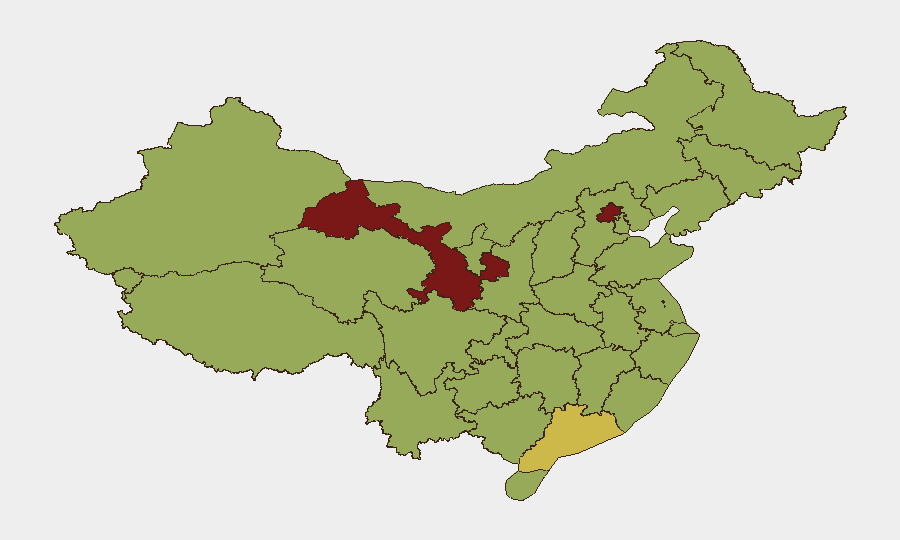
Gansu (86.8) and Beijing (80) rank highest in GeoBit's sub-national composite assessment; however, current operational risk is concentrated in flood-affected regions not at the top of the stable-state ranking—specifically Liaoning, Hebei, Zhejiang, and Fujian. Gansu's elevated score reflects historical trends and structural vulnerabilities rather than immediate weather events. Beijing's proximity to decision-making and diplomatic activity sustains baseline risk. The gap between historical rankings and active weather impacts underscores the importance of real-time event monitoring; coastal provinces and Liaoning should be treated as highest-impact zones for duty-of-care purposes over the next 72 hours, even if they do not rank in the top three on composite scores.
How GeoBit Would Assist
Security teams should deploy AOI Monitoring & Early Warning on Liaoning, Hebei, Zhejiang, and Fujian to track ongoing infrastructure disruption, evacuation progress, and transport corridor reopening timelines. Routing & Network Analysis capabilities can model alternative travel and supply-chain routes around flooded corridors and port delays through 16 July. Multi-language OSINT and social-media intelligence (X, Telegram, YouTube) provide corroborating real-time visibility into localized damage, road submersion, and population movement—critical for validating official announcements and identifying secondary risks to personnel or assets.
7-Day Outlook
Typhoon Bavi's impacts are forecast to peak 14–15 July and gradually clear by mid-week, with port and rail disruptions persisting through 16 July. Yellow-alert rainstorm conditions will likely remain active through mid-week across multiple regions, maintaining elevated flash-flood and landslide risk. Barring secondary severe-weather events or unrelated political incidents, infrastructure and travel disruption will be the dominant risk vector through 18–20 July; conventional security and civil-order risks are not currently elevated.
Highest-Risk Areas — Ranked
| # | State / Region | Risk |
|---|---|---|
| 1 | Gansu | 86.8 |
| 2 | Beijing | 80 |
| 3 | Guangdong Province | 64.5 |
| 4 | Inner Mongolia | 59.8 |
| 5 | Sichuan | 59.3 |
| 6 | Shanghai | 59.2 |
| 7 | Shandong | 59.2 |
| 8 | Jiangsu | 59 |
| 9 | Tibet | 58.8 |
| 10 | Zhejiang | 58.6 |
| 11 | Yunnan | 58.5 |
| 12 | Hainan Province | 58.3 |
Sources
Previous Daily Briefs
A new China brief is written every day — each with its own risk map and downloadable CSV. Here's the last week; use the calendar to go further back.
📅 Browse every day by calendar →
Highlighted days have a brief. Tap a day for that day's map & analysis, or “csv” for that day's dataset ($5).
Atlas — our AI intelligence desk — emails them this snapshot personally. Nothing else, no list.