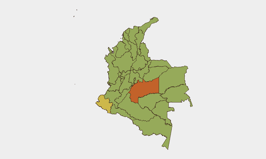
Situation Summary
Colombia remains at composite threat rank #31 globally (score 63), driven primarily by ongoing civil conflict and drug-trafficking violence. The country is experiencing active armed-group operations, police/military installations under attack, and civil unrest across multiple departments. Trajectory is toward sustained volatility in high-risk southern and eastern regions, with no immediate de-escalation signals visible in current event data.
Key Developments
- El Tambo, Cauca — 22 Jul 0600h | Drone attack targeting El Crucero police substation reported; explosive devices launched and second drone observed over General José Hilario López military cantonment. Armed actors engaged police and military positions in ongoing public-order disruption. (Cauca ranks among top 20 conflict zones nationally; drone employment represents tactical escalation.)
- National — 20–21 Jul | Small-arms combat between Colombian armed actors and cross-border elements reported (20 Jul); multiple public statements from government, military, police, and civilian groups issued 21 Jul, signaling political friction around security response and/or military operations.
- National — 21 Jul | Arrest/detention action involving Los Angeles-based entity reported in relation to Colombia operations; details limited but flagged in law-enforcement/narcotics context.
- National — 21 Jul | Municipal and student-group disapproval statements directed at government security measures; indicates civil pushback on enforcement or military presence.
- National — ongoing | 232 tracked events in July to date; event density and multi-actor involvement (police, military, government, armed groups, citizens) reflect sustained instability without concentrated geographic focus, though Meta, Nariño, and Atlántico remain flashpoints.
Highest-Risk Areas
Meta Department (73.8) and Nariño (66.7) dominate the risk profile, both zones of active drug-production and trafficking control contested by multiple armed groups. Atlántico (55.9) and the Capital District (52.8) show elevated risk driven by urban criminal networks and spillover violence; Atlántico's Caribbean port geography and Bogotá's strategic/symbolic importance amplify consequence. Cundinamarca (51.3), which surrounds Bogotá, extends the capital-region vulnerability. Southern and eastern departments (Meta, Nariño, Santander, parts of Antioquia) remain primary conflict zones; northern Caribbean coast (Atlántico, La Guajira, Bolívar) reflects smuggling and gang activity. Personnel and assets in these zones face compounded exposure to combat, kidnapping, and criminal predation.
How GeoBit Would Assist
Security and duty-of-care teams should deploy AOI Monitoring & Early Warning on Meta, Nariño, and Atlántico to detect tactical escalation (drone employment, force concentration) before impact on corporate or personnel operations. Multi-language OSINT (X/Telegram, YouTube, radio SIGINT) combined with Network & Actor Analysis will track armed-group statements, military communications, and civilian sentiment to anticipate localized unrest or government operations. Routing & Network Analysis and GIS & Spatial Analysis enable real-time alternative-route planning for personnel movement in conflict zones, reducing exposure during combat or roadblock scenarios.
7-Day Outlook
Drone attacks on military/police infrastructure indicate armed groups possess improved strike capability and willingness to escalate; expect further incidents in Cauca and adjacent departments. Civilian disapproval statements and student activism suggest political pressure on government to intensify operations, which often triggers retaliatory violence. No ceasefire negotiations are evident; sustained operational tempo and cross-border tensions (Mexico-referenced in 20 Jul event) point toward continued volatility through late July.
Highest-Risk Areas — Ranked
| # | State / Region | Risk |
|---|---|---|
| 1 | Meta Department | 73.8 |
| 2 | Nariño | 66.7 |
| 3 | Atlántico Department | 55.9 |
| 4 | Capital District | 52.8 |
| 5 | Cundinamarca Department | 51.3 |
| 6 | Antioquia Department | 49.2 |
| 7 | Valle del Cauca Department | 48.8 |
| 8 | La Guajira | 45.5 |
| 9 | Bolívar Department | 45.1 |
| 10 | Santander Department | 44.7 |
| 11 | Quindío Department | 44.2 |
| 12 | Archipiélago de San Andrés, Providencia y Santa Catalina Department | 43.8 |
Previous Daily Briefs
A new Colombia brief is written every day — each with its own risk map and downloadable CSV. Here's the last week; use the calendar to go further back.
📅 Browse every day by calendar →
Highlighted days have a brief. Tap a day for that day's map & analysis, or “csv” for that day's dataset ($5).
Atlas — our AI intelligence desk — emails them this snapshot personally. Nothing else, no list.