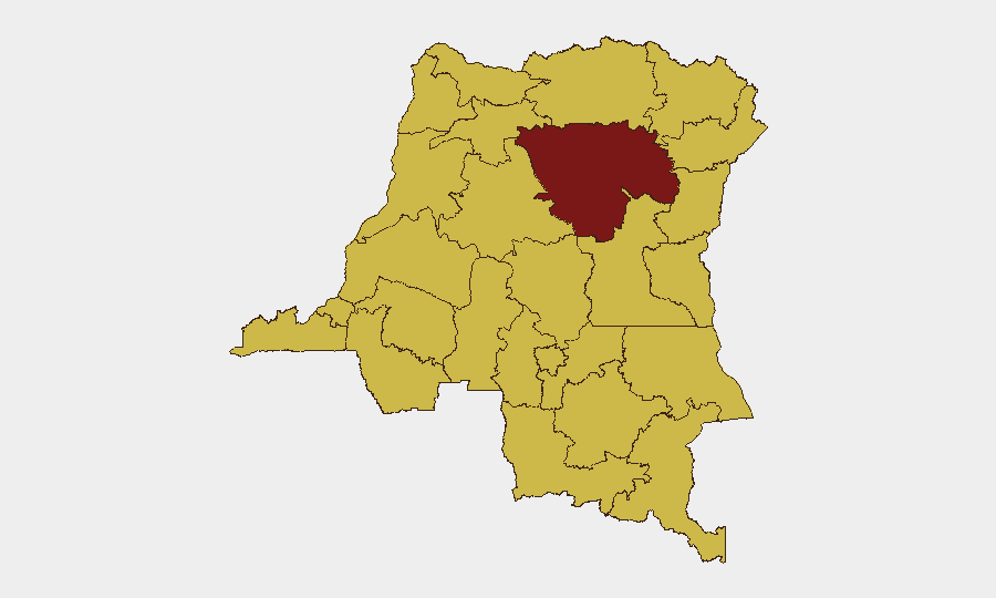
Situation Summary
DR Congo remains the 14th-highest-risk country globally (composite threat score 87), driven primarily by active armed conflict and six tracked security events. The conflict environment is characterized by fragmented non-state armed group (NSAG) activity, intercommunal violence, and limited state capacity across vast territories. The security picture remains fluid and deteriorating in key northeastern and eastern provinces, with humanitarian access constraints and displacement ongoing. Risk trajectory is static to slightly elevated, with no imminent major strategic shift but persistent localized instability.
Key Developments
Note: GeoBit's live web research returned no usable timestamped incidents for the 24–48 hour window (2026-07-11 to 2026-07-13). One event signal was flagged for 2026-07-12 (Public Statement, AFRICA vs SWAHILI), but without corroborating sources or geographic specificity, it does not meet verification standards for operational briefing.
Recommendation: Security teams should cross-check GeoBit's event signal against real-time feeds from MONUSCO, UN OCHA, ACLED, AFP/Reuters, and regional outlets (RFI, Actualité.cd) for confirmed incident details, locations, and casualty/displacement figures. X/Twitter monitoring of DRC security journalists and UN mission accounts (filtered by timestamp) will yield faster initial reporting than wire delays.
Highest-Risk Areas
Tshopo Province (risk 90.7) stands significantly above all other regions and is the primary driver of national threat elevation; it warrants immediate focus for personnel and asset security. The remaining northeastern and eastern belt—Maniema, Nord-Ubangi, Ituri, and North Kivu (all at 60.7)—form a continuous high-risk corridor spanning from the CAR border to the eastern frontier, characterized by NSAG presence, mineral-extraction competition, and limited state authority. Équateur, Mongala, and the Uele provinces carry equivalent elevated risk, primarily from armed group activity and inter-community conflict. The mining-intensive southern provinces (Lualaba, Kasaï periphery) face criminal and artisanal-mining-related violence but are ranked below the northeastern belt.
How GeoBit Would Assist
Security teams should deploy AOI Monitoring & Early Warning on Tshopo and the North Kivu–Ituri corridor, with alerting rules set for armed-group movement, attacks on civilian infrastructure, and displacement events. Multi-language OSINT (Intel Sweep, X/Twitter & Telegram monitoring, regional news feeds) integrated with temporal and entity analysis enables rapid cross-verification of incident reports and identification of false rumors circulating in insecure areas. Conflict & Military force-structure tracking combined with GIS & spatial analysis supports alternative routing and journey-risk assessment for personnel and supply movements, critical for duty-of-care teams managing field operations in Tshopo and eastern provinces.
7-Day Outlook
No major escalation is forecast for the next seven days, but localized NSAG clashes and intercommunal violence in Tshopo, North Kivu, and Ituri remain probable. Humanitarian corridors and border crossings (particularly CAR and Uganda borders) may experience temporary disruption from armed-group activity or checkpointing. Personnel and asset security posture should remain at elevated readiness in all sub-national regions ranked 60.7+, with continuous monitoring of incident and displacement trends feeding into weekly risk reassessment.
Highest-Risk Areas — Ranked
| # | State / Region | Risk |
|---|---|---|
| 1 | Tshopo | 90.7 |
| 2 | Maniema | 60.7 |
| 3 | Sud-Ubangi | 60.7 |
| 4 | Équateur | 60.7 |
| 5 | Nord-Ubangi | 60.7 |
| 6 | Mongala | 60.7 |
| 7 | Lower Uele | 60.7 |
| 8 | Tshuapa | 60.7 |
| 9 | Upper Uele | 60.7 |
| 10 | Ituri | 60.7 |
| 11 | North Kivu | 60.7 |
| 12 | Lualaba | 60.7 |
Previous Daily Briefs
A new DR Congo brief is written every day — each with its own risk map and downloadable CSV. Here's the last week; use the calendar to go further back.
📅 Browse every day by calendar →
Highlighted days have a brief. Tap a day for that day's map & analysis, or “csv” for that day's dataset ($5).
Atlas — our AI intelligence desk — emails them this snapshot personally. Nothing else, no list.