Situation Summary
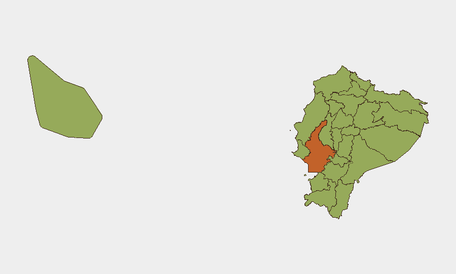
Ecuador remains under acute pressure from drug-trafficking organizations and territorial gang conflicts, with the composite threat score (62) ranking the country #30 globally and driven primarily by narcotics-related violence. The past 48 hours show sustained operational intensity: emergency declarations in border regions, counter-terrorism arrests linked to prison attacks, heavy police/military deployments in major urban centers, and judicial-executive friction over organized-crime prosecutions. Guayas Province—home to Guayaquil and Ecuador's primary port—continues to drive national risk (73.2/100), reflecting both criminal activity and state security responses. The trajectory remains volatile, with no near-term de-escalation signals.
Key Developments
- San Lorenzo, Esmeraldas Province (night 22–23 July): Ecuadorian authorities declared a state of emergency following a surge of armed attacks and gun violence; the Emergency Operations Committee (COE) deployed military and police units with extraordinary security measures in this northern border region.
- Guayaquil, Guayas Province (22 July): Security forces arrested members of a terrorist network linked to a prior car-bomb attack on La Roca prison complex; weapons and explosives control operations conducted by the army, with arrests announced nationally on 22 July.
- Quito, South Sector (22 July): Police arrested two suspects in an organized operation targeting recent criminal activity, with apprehensions reported in the capital's southern neighborhoods.
- Guayaquil, Guayas Province (22 July): The municipality closed at least 13 ticket offices of a major amusement park due to regulatory and safety/compliance issues, affecting crowd flows in a high-traffic public venue.
- Guayaquil, Guayas Province (22 July): Authorities inaugurated the "Acción Segura" security station on Cerro del Carmen, deploying 67 surveillance cameras and 40 metropolitan control agents with 24/7 coverage of surrounding neighborhoods and access routes.
- National Level (22 July): The meteorological institute issued heavy-rain and storm alerts for multiple regions with peak precipitation forecast for 23–24 July, raising risks of road degradation, landslides, and travel disruption.
- Judicial-Executive Tension (21–22 July): Following a complaint by Interior Minister John Reimberg, authorities raided the office of a prosecutor who had pursued substitute measures for an alleged Chone Killers gang leader, signaling escalating friction between executive and judicial branches over organized-crime cases.
Highest-Risk Areas
Guayas Province (73.2) represents a critical concentration of risk, driven by port-based drug trafficking, territorial gang violence, and the density of operations in Guayaquil itself. The remaining nine highest-risk provinces (Manabí, Napo, Santa Elena, Sucumbíos, Orellana, Esmeraldas, Carchi, Imbabura, Santo Domingo, Pichincha, and Galápagos) cluster in the 43.2–43.5 range, reflecting both border proximity to Colombia and internal trafficking routes. Northern and eastern provinces (Esmeraldas, Sucumbíos, Orellana, Carchi, Napo) show sustained activity linked to cross-border criminal networks and coca-production zones. Pichincha (Quito) and Galápagos reflect capital-city vulnerabilities and strategic maritime chokepoints, respectively.
How GeoBit Would Assist
Corporate security teams would deploy AOI Monitoring & Early Warning to track persistent activity in Guayaquil, Quito, and border regions with real-time alerting on escalation signals. Conflict & Military force-structure tracking and Network & Actor Analysis would map criminal-organization command, territorial disputes, and state-security response patterns. Alternative routing and journey planning via Routing & Network Analysis, combined with environmental & health data (e.g., weather impacts on road safety), would support duty-of-care mobility decisions for staff and asset movements.
7-Day Outlook
State emergency measures in northern border regions and ongoing counter-terrorism arrests suggest sustained high operational tempo through early August. Inclement weather (23–24 July) will degrade road conditions and may create tactical opportunities for criminal movement. Without evidence of negotiation or organizational fracture among major trafficking groups, violence levels are likely to remain elevated across Guayas and northern provinces.
Highest-Risk Areas — Ranked
| # | State / Region | Risk |
|---|---|---|
| 1 | Guayas Province | 73.2 |
| 2 | Manabí Province | 43.5 |
| 3 | Napo Province | 43.5 |
| 4 | Santa Elena Province | 43.5 |
| 5 | Sucumbíos Province | 43.2 |
| 6 | Orellana Province | 43.2 |
| 7 | Galápagos | 43.2 |
| 8 | Esmeraldas Province | 43.2 |
| 9 | Carchi Province | 43.2 |
| 10 | Imbabura Province | 43.2 |
| 11 | Santo Domingo de los Tsáchilas Province | 43.2 |
| 12 | Pichincha Province | 43.2 |
Sources
Previous Daily Briefs
A new Ecuador brief is written every day — each with its own risk map and downloadable CSV. Here's the last week; use the calendar to go further back.
📅 Browse every day by calendar →
Highlighted days have a brief. Tap a day for that day's map & analysis, or “csv” for that day's dataset ($5).
Atlas — our AI intelligence desk — emails them this snapshot personally. Nothing else, no list.