Situation Summary
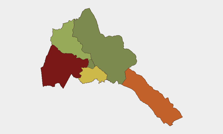
Eritrea remains a low-frequency threat environment globally (rank #75, composite score 24), with no discrete security incidents recorded in the current 24-48 hour window. The country's risk profile is heavily concentrated in border and western regions, particularly Gash-Barka and the Southern Red Sea, reflecting historical tensions tied to land disputes, port competition with Ethiopia, and limited state capacity in peripheral zones. The capital region (Maekel) maintains substantially lower risk. Overall trajectory shows stability in major urban centers but persistent vulnerability in remote, under-governed areas.
Key Developments
No verified security, conflict, crime, or infrastructure incidents specific to Eritrea were identified in web sources covering August 30–31, 2026. Regional developments—including ongoing US–Iran military activity in the Persian Gulf and broader Red Sea dynamics—do not currently show direct operational impact within Eritrea's borders. An August 28 report confirmed that a tanker flying an Eritrean flag and hijacked off Yemen was not legitimately registered to Eritrea, representing a maritime-compliance issue rather than a domestic security event. Political-strategic background: Ethiopia–Eritrea tensions over Red Sea port access and reported joint military coordination date to August 26 and earlier; no new escalation is reported as of August 31.
Highest-Risk Areas
Gash-Barka (score 92) and the Southern Red Sea Region (score 75) dominate Eritrea's threat landscape, driven by remote terrain, weak administrative control, cross-border smuggling networks, and unresolved land boundaries with Sudan and Ethiopia respectively. Debub Region (score 68) faces similar pressures. These three zones account for nearly all elevated risk; by contrast, Maekel Region (score 18) and the Northern Red Sea (score 0) reflect the concentration of state authority and relative security in and around Asmara and the northern coast. Organizations with personnel or supply chains in the western and southern periphery face higher exposure to banditry, informal taxation, and infrastructure disruption than those operating in the capital or northern zones.
How GeoBit Would Assist
Corporate teams should leverage AOI Monitoring & Early Warning to establish persistent surveillance of Gash-Barka, Southern Red Sea, and Debub—triggering alerts on border incursions, bandit activity, or supply-route disruptions. Conflict & Military and Border & Disputed-Territory Search capabilities enable tracking of Ethiopia–Eritrea dynamics and Sudan cross-border movements that could spill into high-risk western regions. Routing & Network Analysis supports identification of secure transit corridors and contingency supply-chain re-routing around vulnerable areas, critical for businesses operating across the country.
7-Day Outlook
No acute escalation is forecast for the near term; Eritrea's political environment remains tightly controlled and external military pressure remains indirect. However, the confluence of Ethiopia–Red Sea port competition and Sudan-border fragility means that any regional flare-up—particularly around maritime or land disputes—could rapidly raise risk in Gash-Barka and Southern Red Sea. Organizations should maintain heightened situational awareness in peripheral zones and confirm staff-movement protocols in high-risk regions.
Highest-Risk Areas — Ranked
| # | State / Region | Risk |
|---|---|---|
| 1 | Gash-Barka | 92 |
| 2 | Southern Red Sea Region | 75 |
| 3 | Debub Region | 68 |
| 4 | Anseba | 55 |
| 5 | Maekel Region | 18 |
| 6 | Northen Red Sea Region | 0 |
Sources
Previous Daily Briefs
A new Eritrea brief is written every day — each with its own risk map and downloadable CSV. Here's the last week; use the calendar to go further back.
- August 29, 2026
- August 27, 2026
- August 25, 2026
- August 23, 2026
- August 21, 2026
- August 19, 2026
- August 17, 2026
📅 Browse every day by calendar →
Highlighted days have a brief. Tap a day for that day's map & analysis, or “csv” for that day's dataset ($5).
Atlas — our AI intelligence desk — emails them this snapshot personally. Nothing else, no list.