Situation Summary
Iran is experiencing acute military escalation with the United States following Iranian attacks on commercial shipping in the Strait of Hormuz on July 7–8. U.S. Central Command conducted retaliatory airstrikes on Iranian military targets in Bushehr and Hormozgan provinces on July 8, killing at least eight Iranian military personnel and damaging radar and military infrastructure. Iranian leadership has issued explicit threats to close the Strait of Hormuz and escalate coastal defenses, signaling imminent risk of further direct conflict and potential disruption to global shipping and energy markets.
Key Developments
- Bandar Abbas & Bushehr Province, July 8 – U.S. airstrikes killed eight Iranian air force and navy personnel and struck two military bases; Iranian state media confirmed explosions and damage to military infrastructure in the southern coastal region.
- Strait of Hormuz, July 7–8 – Iranian forces attacked three commercial vessels transiting the Strait; U.S. forces subsequently intercepted dozens of hostile drones and missiles in response, according to regional defense authorities and CENTCOM.
- Bushehr Province, July 8 (evening) – U.S. Central Command conducted a second wave of strikes targeting radar systems and coastal defense assets used in the Iranian attacks on shipping, described as retaliatory operations.
- Iran's Southern Coastline (general), July 8 – Iran's Army Chief of Staff declared that Iranian forces would make the southern coastline a "hell" for U.S. forces if further attacks occur, signaling military mobilization in Hormozgan and Bushehr provinces.
- National-level threat statement, July 8 – An unnamed Iranian regime source warned via state media that Iran would "immediately" close the Strait of Hormuz to all traffic in response to further strikes, framing blockade as an escalation trigger.
- Kharg Island, July 8 – President Trump threatened new U.S. strikes on Iranian civilian oil infrastructure and seizure of Kharg Island if attacks continue, elevating risk to Iran's primary export facilities.
Highest-Risk Areas
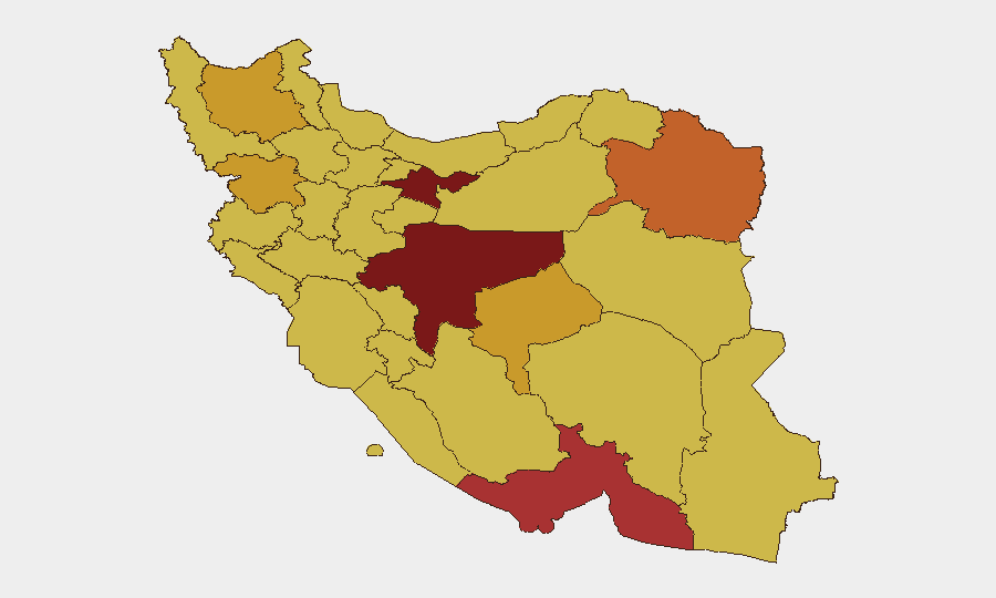
Tehran Province (risk 100) remains the administrative and decision-making center; however, operational conflict risk is now concentrated in southern coastal provinces: Hormozgan (79.2) and Bushehr (included in the broader risk calculation) face direct military strikes and are staging areas for Iranian coastal defense. Isfahan (89.7) and Razavi Khorasan (73.6) may see secondary impacts if escalation spreads inland or if U.S. targeting expands. The ranking reflects sustained tension across much of Iran; the current 24–48-hour situation is concentrated in the south, particularly around Bandar Abbas and the Strait of Hormuz, where military infrastructure, personnel, and shipping traffic are under active threat.
How GeoBit Would Assist
Security teams should deploy AOI Monitoring & Early Warning on Hormozgan, Bushehr, and the Strait of Hormuz corridor with real-time alerting for military activity, vessel transits, and regime statements. Maritime & Aviation tracking combined with Conflict & Military battle mapping and force-structure monitoring will provide continuous visibility into Iranian and U.S. military positioning, asset movements, and closure risk to the Strait. Intel Sweep, X/Telegram OSINT, and multi-language sentiment analysis enable early detection of regime announcements and military readiness signals that may precede further escalation or blockade implementation.
7-Day Outlook
Escalation risk remains acute through mid-July. If either Iran or the U.S. conducts further strikes, rapid closure of the Strait of Hormuz becomes a material threat, with global energy and shipping implications. Organizations with personnel, supply chains, or assets in southern Iran or dependent on Strait transits should prepare contingency protocols and monitor daily for blockade announcements or additional military activity.
Highest-Risk Areas — Ranked
| # | State / Region | Risk |
|---|---|---|
| 1 | Tehran Province | 100 |
| 2 | Isfahan Province | 89.7 |
| 3 | Hormozgan Province | 79.2 |
| 4 | Razavi Khorasan | 73.6 |
| 5 | Yazd Province | 71.9 |
| 6 | Kurdistan Province | 71.3 |
| 7 | East Azerbaijan Province | 71.2 |
| 8 | Kohgiluye and Buyer Ahmad Province | 70.6 |
| 9 | Sistan and Baluchestan Province | 70.6 |
| 10 | Lorestan Province | 70.4 |
| 11 | West Azerbaijan Province | 70.2 |
| 12 | Fars Province | 70.1 |
Sources
Previous Daily Briefs
A new Iran brief is written every day — each with its own risk map and downloadable CSV. Here's the last week; use the calendar to go further back.
📅 Browse every day by calendar →
Highlighted days have a brief. Tap a day for that day's map & analysis, or “csv” for that day's dataset ($5).
Atlas — our AI intelligence desk — emails them this snapshot personally. Nothing else, no list.