Situation Summary
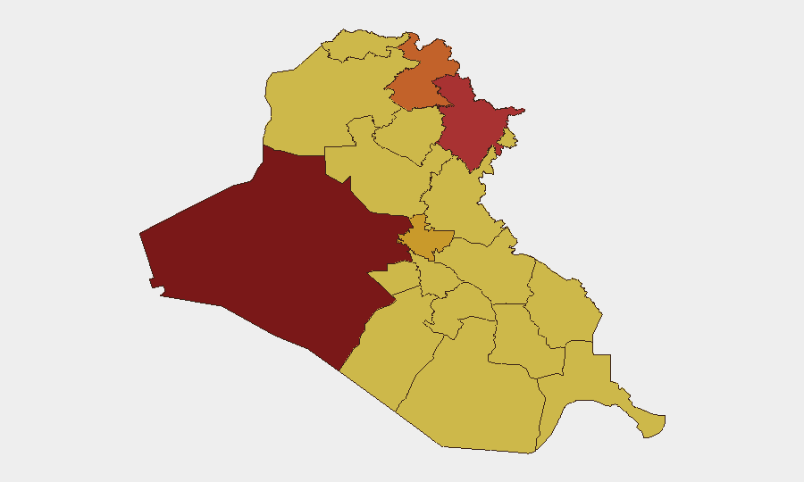
Iraq remains at elevated threat level (#8 globally, composite score 100) with 369 tracked events, driven primarily by sustained drone activity in the Kurdistan Region, regional military posturing, and unresolved tensions between state and non-state actors. The past 48 hours have seen intensified aerial weapons activity concentrated in Erbil and Sulaymaniyah, with multiple intercept operations and no reported casualties to date. Al-Anbar Governorate and the Kurdistan Region (Erbil and Sulaymaniyah) dominate current risk, while Baghdad and southern governorates remain elevated due to underlying political fragmentation and militia presence. The trajectory is one of sustained tension without immediate de-escalation signals.
Key Developments
- Erbil, Kurdistan Region – July 17: Coalition air defenses intercepted eight explosive-laden drones near the U.S. consulate and adjacent coalition facilities; no casualties reported. Additional reporting indicates 16 drones across six attack swarms intercepted in coordinated operations covering both Erbil and Sulaymaniyah on the same date.
- Sulaymaniyah, Kurdistan Region – July 17: U.S.-led Coalition air defenses engaged drone swarms targeting Iranian Kurdish opposition positions and broader strategic sites; sustained interception success with no civilian impact.
- Baghdad – July 16: U.S. Embassy in Iraq issued a security alert to American nationals nationwide, directing heightened readiness, continuous local-media monitoring, and preparation for possible airspace closures and travel disruption amid ongoing regional drone activity.
- Northern Iraq – July 16–17: Regional security assessment confirmed ongoing aerial-weapons pressure on the Kurdistan Region with no clear near-term de-escalation pathway; coalition and Kurdish forces sustained active air-defense posture.
- Event Signal Compilation – July 17–20: GeoBit tracked multiple conventional military force signals involving Iraq, the U.S., and military actors, alongside demand signals from Iranian actors and one unconventional-violence incident recorded July 19. A detention event was recorded in Basra authorities on July 19.
Highest-Risk Areas
Al-Anbar Governorate (risk 100) and the Kurdistan Region—specifically Erbil (75.9) and Sulaymaniyah (76.7)—are the primary drivers of national risk. Erbil and Sulaymaniyah are under sustained drone pressure from external actors, with repeated intercept operations indicating deliberate targeting of U.S. and coalition presence; Al-Anbar's maximal score reflects long-standing insurgent and militia activity. Baghdad (72.8), southern Shia-majority governorates (Karbala, Al-Najaf, Dhi Qar; all 70–70.3), and central regions (Nineveh, Babil, Wasit; all 70–70.1) carry moderate-to-elevated risk stemming from militia fragmentation, political volatility, and residual extremist pockets. Corporate assets and personnel in Erbil face the most acute immediate threat; Baghdad operations require standard duty-of-care vigilance.
How GeoBit Would Assist
Security teams operating in Iraq should employ AOI Monitoring & Early Warning to establish persistent watch zones over corporate facilities and personnel clusters in high-risk governorates—particularly Erbil and Baghdad—with automated alerting on drone activity, military movements, and incident clustering. Conflict & Military force-structure and weapons-capability tracking, combined with Network & Actor Analysis, will clarify which external actors are directing current drone operations and their operational cycle. Intelligence & OSINT fusion across event feeds, social media, and entity extraction will provide real-time signal discrimination and early tactical warning of escalation or de-escalation.
7-Day Outlook
Drone pressure on the Kurdistan Region is likely to persist at current or elevated levels over the next 7 days, with no clear diplomatic off-ramp visible in open reporting. Baghdad and southern governorates should remain under standard elevated monitoring; militia fragmentation and Shia political dynamics create slow-burn risk rather than acute tactical threat. Corporate duty-of-care requirements should include daily airspace advisories, consulate alert subscriptions, and contingency routing via Routing & Network Analysis if air-mobility restrictions widen.
Highest-Risk Areas — Ranked
| # | State / Region | Risk |
|---|---|---|
| 1 | Al-Anbar Governorate | 100 |
| 2 | Sulaymaniyah Governorate | 76.7 |
| 3 | Erbil Governorate | 75.9 |
| 4 | Baghdad Governorate | 72.8 |
| 5 | Dhi Qar Governorate | 70.3 |
| 6 | Karbala | 70.3 |
| 7 | Al-Najaf Governorate | 70.1 |
| 8 | Nineveh Governorate | 70.1 |
| 9 | Babil Governorate | 70 |
| 10 | Wasit Governorate | 70 |
| 11 | Al-Qadisiyah Governorate | 70 |
| 12 | Al-Muthanna Governorate | 70 |
Sources
Previous Daily Briefs
A new Iraq brief is written every day — each with its own risk map and downloadable CSV. Here's the last week; use the calendar to go further back.
📅 Browse every day by calendar →
Highlighted days have a brief. Tap a day for that day's map & analysis, or “csv” for that day's dataset ($5).
Atlas — our AI intelligence desk — emails them this snapshot personally. Nothing else, no list.