Situation Summary
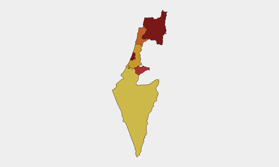
Israel faces elevated security tensions across multiple vectors as of 31 July 2026, with a composite threat score of 93 (rank #11 globally) driven by active military operations, diplomatic friction, and civil unrest. Recent signals indicate conventional military engagements involving Israeli forces, Hamas, and Palestinian armed groups, alongside government public statements and international diplomatic sanctions. Tel Aviv and the North District present the highest sub-national risk (95.3 each), while West Bank operations in the Nablus area have generated nationalist-crime incidents including arson in the past 48 hours. The trajectory shows sustained tension rather than de-escalation.
Key Developments
- West Bank / Nablus (past 48h): Israeli forces conducted operations to arrest wanted suspects and locate weapons; parallel nationalist-crime incidents reported, including arson of a mosque and vehicles, with force reinforcements in the area.
- 31 July · Conventional Military Operations: Active military force deployments recorded in Israel, Gaza, and involving Hamas, indicating ongoing tactical engagement without reported major ceasefire movement.
- 31 July · Diplomatic Response: Administrative sanctions applied to diplomat(s) and international banking restrictions (BANK vs CENTRAL BANK) suggest secondary economic/diplomatic fallout from the military situation.
- 31 July · Public Statements: Government and Israel issued formal public statements; Hamas issued countering statements, typical of active-phase conflict communication.
- 31 July · Civil Unrest: Demonstrators (including pro-Palestine protesters in Britain) organized rallies, indicating international solidarity dimensions and potential domestic protest activity.
- 28 July · Intelligence Investigation: Military intelligence reported investigation of a battalion, suggesting internal security review or potential misconduct inquiry.
- Refugee Status Involvement: Military force event flagged "refugee" categorization, potentially indicating displacement, humanitarian access, or refugee-camp-related security incidents.
Highest-Risk Areas
Tel Aviv District and North District share the highest composite risk (95.3 each), reflecting dense population, critical infrastructure, and proximity to active conflict zones. The North District's elevation correlates with ongoing military operations and escalating West Bank tensions. Jerusalem District (79.7) remains elevated due to its political significance and mixed Arab-Jewish demographics, while Haifa (75.5) and the Center District (72.5) experience secondary spillover risk. South District (68.9) remains lower-risk but remains monitored. Risk distribution reflects geographic proximity to Palestinian Authority areas, military operational tempo, and civil unrest flashpoints.
How GeoBit Would Assist
Intel Sweep & OSINT Fusion provides real-time corroboration of military movements, public statements, and protest activity across X/Twitter, Telegram, and news feeds with multi-language capability and entity extraction to isolate threats to specific corporate assets. AOI Monitoring & Early Warning with persistent satellite and ground-truth alerting on Tel Aviv, North District, and Nablus enables duty-of-care teams to receive threshold-based alerts before incidents cascade. Conflict & Military mapping combined with GIS & Spatial Analysis supports alternative routing for personnel and supply chains away from active zones, while Network & Actor Analysis identifies which armed groups or state actors pose direct vs. indirect risk to corporate operations.
7-Day Outlook
Military operations and diplomatic friction are unlikely to resolve in the next week; sustained conventional force deployment and public statements signal medium-term engagement. West Bank nationalist incidents and protest activity may spread to urban centers (Tel Aviv, Haifa, Jerusalem), creating localized security incidents rather than systemic collapse. Corporate security posture should anticipate continued elevated alert levels, restricted movement in North and Tel Aviv districts, and intermittent transport/commercial disruptions.
Highest-Risk Areas — Ranked
| # | State / Region | Risk |
|---|---|---|
| 1 | Tel-Aviv District | 95.3 |
| 2 | North District | 95.3 |
| 3 | Jerusalem District | 79.7 |
| 4 | Haifa District | 75.5 |
| 5 | Center District | 72.5 |
| 6 | South District | 68.9 |
Sources
Previous Daily Briefs
A new Israel brief is written every day — each with its own risk map and downloadable CSV. Here's the last week; use the calendar to go further back.
📅 Browse every day by calendar →
Highlighted days have a brief. Tap a day for that day's map & analysis, or “csv” for that day's dataset ($5).
Atlas — our AI intelligence desk — emails them this snapshot personally. Nothing else, no list.