Situation Summary
Mali is experiencing a coordinated multi-location insurgent offensive as of 2026-07-08, with armed groups—primarily the Azawad Liberation Front (FLA)—launching simultaneous attacks across the north, center, and periphery of the capital region. Five major sites came under assault: military positions in Anefis and Aguelhok (Kidal), an army camp in Gao, an airbase vicinity in Sévaré (Mopti), and the strategically significant Kenieroba prison complex near Bamako. Malian armed forces report the situation as "under control," but ongoing clashes and the breadth of the coordinated action indicate a significant escalation in militant capability and coordination. The trajectory suggests heightened instability across the north and center, with ripple effects on security posture nationwide.
Key Developments
- Anefis, Kidal region (2026-07-08, ~05:00 GMT): FLA-led insurgents attacked Malian army positions; FLA spokesperson reported several positions had fallen with fighting continuing inside the town. Residents confirmed gunfire and armed group presence.
- Aguelhok, Kidal region (2026-07-08, ~05:00 GMT): Coordinated insurgent attacks on one of the last major Malian army positions in Kidal; ongoing combat and explosions reported as part of the broader offensive.
- Gao city, Gao region (2026-07-08): Residents reported gunfire and loud blasts near an army camp; clashes between armed groups and security forces in this northern urban center during simultaneous insurgent action.
- Sévaré, Mopti region (2026-07-08, ~05:00 GMT): Explosions of unclear origin heard; multiple aircraft observed flying over the area shortly after, indicating aerial response by Malian forces to possible militant activity.
- Kenieroba prison complex, Bamako periphery (2026-07-08): Major detention facility holding jihadist prisoners came under attack with sustained gunfire; prisoners sheltering in cells, indicating serious breach at a key national security asset within kilometers of the capital.
- Nationwide coordinated assault (2026-07-08): Malian military confirmed five coordinated attack locations across northern, central, and peri-capital regions, marking an unusually synchronized insurgent operation.
Highest-Risk Areas
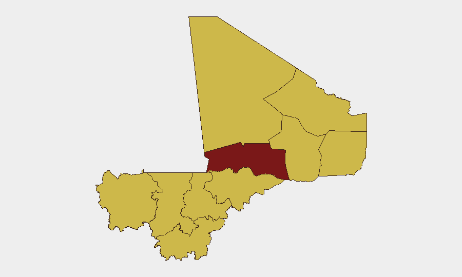
Timbuktu leads the sub-national risk ranking at 99.9, reflecting its history as a militant stronghold and insurgent recruitment/logistics hub. Nine additional regions—including Kidal, Gao, and Mopti, where the 2026-07-08 attacks occurred—are assessed at 69.9, indicating sustained militant presence, weak state control, and proven attack capability. Notably, Bamako itself carries equal risk (69.9), reflecting the Kenieroba prison attack's proximity and the security establishment's vulnerability to coordinated assault. The concentration of risk across the Sahel arc (north and center) and now visibly extending to the capital's immediate vicinity underscores both geographic fragmentation of state authority and the operational reach of insurgent networks.
How GeoBit Would Assist
Organizations with personnel or assets in Mali would deploy AOI Monitoring & Early Warning on high-risk regions and critical infrastructure (airports, camps, detention facilities, supply routes) to detect pre-attack mobilization and receive immediate alerts on incidents. Battle Mapping and force-structure tracking would clarify real-time control of towns and military positions, distinguishing propaganda from ground reality—critical for duty-of-care decisions. Routing & Network Analysis would identify safer transit corridors and alternative supply/evacuation pathways given the current conflict footprint.
7-Day Outlook
The coordinated nature of 2026-07-08 attacks suggests a period of sustained insurgent pressure, likely including follow-on assaults or prisoner-rescue attempts. Military counter-operations will intensify, particularly in Kidal and Gao, but logistical strain may limit state response capacity. Security teams should expect restricted movement, heightened checkpoints, and potential secondary incidents in Bamako and surrounding zones through mid-July.
Highest-Risk Areas — Ranked
| # | State / Region | Risk |
|---|---|---|
| 1 | Timbuktu | 99.9 |
| 2 | Ménaka | 69.9 |
| 3 | Kayes | 69.9 |
| 4 | Taoudénit Region | 69.9 |
| 5 | Kidal | 69.9 |
| 6 | Gao | 69.9 |
| 7 | Bamako | 69.9 |
| 8 | Koulikoro | 69.9 |
| 9 | Ségou Region | 69.9 |
| 10 | Sikasso Region | 69.9 |
| 11 | Mopti | 69.9 |
Sources
Previous Daily Briefs
A new Mali brief is written every day — each with its own risk map and downloadable CSV. Here's the last week; use the calendar to go further back.
📅 Browse every day by calendar →
Highlighted days have a brief. Tap a day for that day's map & analysis, or “csv” for that day's dataset ($5).
Atlas — our AI intelligence desk — emails them this snapshot personally. Nothing else, no list.