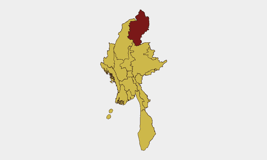
Situation Summary
Myanmar remains in active civil war following the February 2021 coup, with fragmented control across multiple armed groups and persistent armed conflict across the north, northeast, and peripheral regions. The current 24-48 hour period shows no major verified conflict escalation or localized incidents in available open sources, though underlying structural instability persists across 11 of 14 major administrative divisions. Diplomatic engagement (India–Myanmar border security talks, 9 July) reflects international efforts to manage spillover risks from the conflict rather than de-escalation on the ground. The threat environment remains elevated and volatile, particularly in border zones and contested territory.
Key Developments
- New Delhi, India (9 July 2026): India and Myanmar held the 23rd National Level Meeting, agreeing to strengthen cross-border cooperation on terrorism, insurgency, narcotics trafficking, illegal arms smuggling, human trafficking, wildlife crime, and cybercrime. The meeting underscores international concern over spillover effects from Myanmar's civil war into neighboring countries and signals ongoing instability in border regions.
- No major localized conflict or civil unrest events verified in the past 24–48 hours in available open-source reporting. Historical reporting through early July documents ongoing displacement in Magway/Pakokku and airstrikes in northern zones, but specific incident-level updates from 8–10 July are not presently visible in mainstream English-language or corroborated regional sources accessible to this analysis.
*Note: Comprehensive real-time incident tracking for Myanmar requires access to ACLED live feeds, Myanmar Witness network reports, and local-language media (Eleven Myanmar, Mizzima) and junta/resistance social-media channels, which are not included in the current web results provided. Corporate security teams should supplement this brief with dedicated monitoring of those sources.*
Highest-Risk Areas
Kachin State (risk 100) remains the single highest-risk zone, driven by active armed group control, remote geography, and cross-border displacement into India and China. The next tier—Tanintharyi, Shan, Chin, Sagaing, Wa State, and all major urban and lowland regions (Magway, Mandalay, Rakhine, Ayeyarwady, Yangon, Naypyitaw)—all register risk 70, indicating sustained conflict, militia activity, or spillover instability. This near-universal elevation across the country reflects the civil war's geographic breadth and the fragmentation of state authority; no region is insulated from underlying threat.
How GeoBit Would Assist
Security teams protecting personnel or assets in Myanmar should employ AOI (Area-of-Interest) Monitoring & Early Warning on Kachin State, key supply routes, and corporate operating zones to detect conflict escalation or roadblock activity in near-real time. OSINT fusion combining X/Twitter, Telegram, and local media feeds with multi-language search and sentiment analysis will surface emerging militia announcements, curfews, or armed-group activity ahead of mainstream reporting. GIS & Spatial Analysis linked to satellite imagery can track displacement flows, camp activity, and armed-group positioning to inform duty-of-care decisions on travel, supply-chain routing, and personnel relocation.
7-Day Outlook
No imminent, localized escalation is evident in the 24-48 hour horizon, but the underlying civil war shows no signs of resolution or major battlefield shift. Border volatility and cross-country spillover (narcotics, weapons, insurgent transit) will likely remain elevated, particularly in Sagaing, Kachin, and Shan states, as Indian and Thai governments manage their own border security. Corporate operations should maintain heightened vigilance and contingency protocols in all red and orange zones.
Highest-Risk Areas — Ranked
| # | State / Region | Risk |
|---|---|---|
| 1 | Kachin State | 100 |
| 2 | Tanintharyi Region | 70 |
| 3 | Shan State | 70 |
| 4 | Chin | 70 |
| 5 | Sagaing Region | 70 |
| 6 | Wa State (Northern Region) | 70 |
| 7 | Magway | 70 |
| 8 | Mandalay | 70 |
| 9 | Rakhine | 70 |
| 10 | Ayeyarwady | 70 |
| 11 | Yangon | 70 |
| 12 | Naypyitaw Union Territory | 70 |
Sources
Previous Daily Briefs
A new Myanmar brief is written every day — each with its own risk map and downloadable CSV. Here's the last week; use the calendar to go further back.
📅 Browse every day by calendar →
Highlighted days have a brief. Tap a day for that day's map & analysis, or “csv” for that day's dataset ($5).
Atlas — our AI intelligence desk — emails them this snapshot personally. Nothing else, no list.