Situation Summary
Nigeria remains the world's highest-threat country (composite score 100), with 697 tracked security events driven primarily by active insurgency, banditry, and kidnapping networks across multiple regions. Over the past 48 hours, the country has experienced coordinated mass-casualty attacks in the north-central belt—particularly Benue State—and a nationwide law-enforcement surge, reflecting simultaneous pressure from armed groups and an intensified government response. The convergence of rural mass killings, presidential-level security mobilization, and broad inter-agency operations indicates escalating tension across Nigeria's conflict landscape and heightened political urgency.
Key Developments
- Otukpo-Nobi, Benue State (07-13, early morning): Armed gunmen attacked residents following a funeral, killing 8–18 people (police confirmed 8 dead, 5 wounded; residents report 18) and triggering mass protests and road blockages demanding improved security. Police characterize the incident as a "purely terrorist attack" employing guerrilla tactics.
- North-central belt multi-location attacks (07-12 to 07-13, weekend): Coordinated or sequential attacks across Benue (Akpachi, Otukpo-Nobi), Plateau (Wereng-Camp, Kum), and Niger (Borgu LGA) states killed at least 36 people, including women, children, and infants; one vehicle struck an IED on the Dakera-Babanna road in Niger.
- Nationwide police operations (07-14, within last 24 hours): Nigeria Police Force conducted synchronized raids across 11 states (Anambra, Bayelsa, Benue, Delta, Gombe, Nasarawa, Niger, Ogun, Osun, Bauchi, Zamfara), arresting 43 suspected criminals, rescuing 6 kidnap victims, and recovering firearms and stolen property.
- Presidential emergency security meeting (07-14, Abuja): President Bola Tinubu convened an urgent security session with military and intelligence leadership in response to escalating kidnappings and banditry, signaling top-level concern and potential shift in operational posture.
- Benue State police investigations ongoing (07-13 onwards): Authorities have intensified efforts to track perpetrators and establish links between weekend attacks in Otukpo LGA and earlier killings in the same area, suggesting a localized or sustained campaign.
Highest-Risk Areas
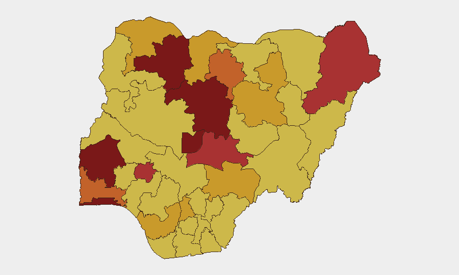
Oyo State (risk 100) and Lagos State (93.5) rank highest, reflecting urban crime, organized trafficking, and institutional volatility in Nigeria's commercial and administrative heartland. However, the north-central belt—Benue (71.7), Nasarawa (76.2), Niger (not separately ranked but operationally active), and Plateau—is currently the primary source of mass-casualty incidents and active armed-group operations. Kaduna (80.8), Zamfara (83.6), and Borno (79.8) remain under severe pressure from banditry and insurgency. The elevated risk scores in FCT (83.8) reflect both institutional instability and spillover violence from surrounding states.
How GeoBit Would Assist
Security teams protecting personnel or assets in Nigeria should deploy AOI Monitoring & Early Warning on high-risk states—particularly Benue, Kaduna, and Zamfara—to capture emerging attack patterns and timing. Network & Actor Analysis and OSINT fusion (X, Telegram, radio SIGINT, multi-language search) enable rapid identification of coordinated operations and threat-actor intent. Routing & Network Analysis supports alternative journey planning around active conflict zones and recent attack clusters, while Conflict & Military mapping tracks armed-group movement and force composition in real time.
7-Day Outlook
Expect continued high-tempo bandit and insurgent operations in the north-central and northwest zones, with weekend attacks likely to persist in Benue and surrounding LGAs. Government operations will intensify in response to presidential-level pressure, creating a volatile landscape of active enforcement and counter-operations. The discrepancy between official casualty figures and community reports suggests rising public anger, increasing risk of civil unrest and roadblocks in affected areas.
Highest-Risk Areas — Ranked
| # | State / Region | Risk |
|---|---|---|
| 1 | Oyo State | 100 |
| 2 | Lagos State | 93.5 |
| 3 | Federal Capital Territory | 83.8 |
| 4 | Zamfara State | 83.6 |
| 5 | Kaduna State | 80.8 |
| 6 | Borno State | 79.8 |
| 7 | Ekiti State | 77.4 |
| 8 | Nasarawa State | 76.2 |
| 9 | Ogun State | 75.6 |
| 10 | Kano State | 74.2 |
| 11 | Bauchi State | 72 |
| 12 | Benue State | 71.7 |
Sources
Previous Daily Briefs
A new Nigeria brief is written every day — each with its own risk map and downloadable CSV. Here's the last week; use the calendar to go further back.
📅 Browse every day by calendar →
Highlighted days have a brief. Tap a day for that day's map & analysis, or “csv” for that day's dataset ($5).
Atlas — our AI intelligence desk — emails them this snapshot personally. Nothing else, no list.