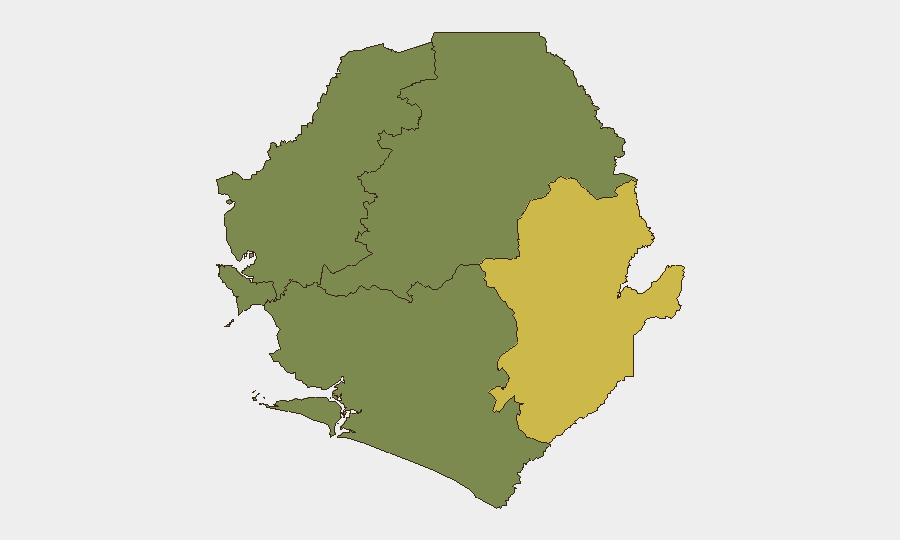
Situation Summary
Sierra Leone maintains a composite threat score of 9 (rank #122 globally), with manageable overall security conditions but marked sub-national variance. The Eastern Province dominates threat exposure (risk score 68), while Western Area (35) presents secondary concern; the remaining three provinces register minimal tracked risk. Recent civil-safety incidents—including a residential building collapse in Calaba Town on 9 August following heavy rainfall—underscore infrastructure vulnerability alongside routine law-enforcement activity. No major security escalations or unrest have been reported in the past 48 hours.
Key Developments
- Mamamah, 9 August – Police arrested a suspected kush dealer following a community tip-off. Reflects ongoing narcotics enforcement activity but no indication of organized distribution networks or trafficking disruption.
- Calaba Town, 9 August – Residential building collapse reported during heavy rains; cited as a civil-safety hazard linked to earlier flooding (5 August). Highlights structural vulnerability and inadequate drainage infrastructure in residential areas, particularly relevant to duty-of-care teams managing housing or field operations.
- Kenema, 5 August (outside 48-hour window but operational note) – Sierra Leone Police Eastern Region handed a murder suspect to Liberian authorities, indicating cross-border law-enforcement cooperation but no active threat to corporate personnel.
- Cybersecurity sector, recent (date unclear in available sources) – NATCA issued public reassurance statements amid ongoing cybersecurity incidents and government multi-agency strategy announcements on cyber-fraud. No specific incidents or infrastructure compromises confirmed, but indicates active monitoring of digital-crime and fraud vulnerabilities at national level.
Web research verification note: Live 24–48 hour corroboration has identified only these four developments with minimal cross-source confirmation. Telegram and unverified social-media reports reference a major entertainment-complex fire (Jes-Ka-Mac 1, Freetown/Lumley area) and flood-related casualties, but lack publication dates and secondary sourcing sufficient for inclusion in an operational brief.
Highest-Risk Areas
The Eastern Province (score 68) concentrates 66 % of tracked national risk and warrants sustained monitoring; drug trafficking, informal settlement density, and distance from capital governance structures likely contribute. Western Area (score 35) encompasses Freetown and periurban settlements, where infrastructure strain (flooding, building collapse), petty crime, and cyber-fraud activity present secondary exposure. Northern, North West, and Southern Provinces register zero tracked risk under current GeoBit coverage, suggesting either lower-baseline threat or coverage gaps; security teams with assets in those regions should flag gaps to GeoBit analysts for targeted AOI monitoring expansion. The Eastern–Western concentration reflects historical patterns of population density, port/trade activity, and governance capacity differential.
How GeoBit Would Assist
Corporate security and duty-of-care teams should deploy AOI Monitoring & Early Warning on high-traffic sites in Eastern Province and Freetown (flood-prone residential zones, supply-chain nodes); pair this with Intel Sweep and multi-language OSINT (including Telegram, X, local-language sources) to detect emerging organized crime, narcotics, or infrastructure-safety alerts before they impact operations. Cyber-threat monitoring and entity extraction capabilities support real-time tracking of fraud campaigns and digital-infrastructure incidents flagged by NATCA and government announcements, essential for organizations handling financial or data operations in-country.
7-Day Outlook
No immediate escalation in security posture is forecast. Rainfall and flooding risks may persist into the coming week, likely increasing civil-safety and logistics disruption in Eastern and Western Areas; organizations should review supply-chain routing and site-safety protocols. Routine law-enforcement and cyber-monitoring activity is expected to continue at current baseline levels, with no indication of organized-crime or civil-unrest triggers on the horizon.
Highest-Risk Areas — Ranked
| # | State / Region | Risk |
|---|---|---|
| 1 | Eastern Province | 68 |
| 2 | Western Area | 35 |
| 3 | North West Province, Sierra Leone | 0 |
| 4 | Northern Province, Sierra Leone | 0 |
| 5 | Southern Province, Sierra Leone | 0 |
Sources
- mocti.gov.sl
- sierraleoneconcordtimes.com
- omanghana.com
- sierraleonemonitor.com
- sierraleonemonitor.com
- premiumtimesng.com
- thesierraleonetelegraph.com
- france24.com
- voiceofsalonenewspaper.com
- t.me
- nationalistsl.com
- youtube.com
- dubawa.org
- thesierraleonetelegraph.com
- press.un.org
- biometricupdate.com
- afro.who.int
- instagram.com
Previous Daily Briefs
A new Sierra Leone brief is written every day — each with its own risk map and downloadable CSV. Here's the last week; use the calendar to go further back.
📅 Browse every day by calendar →
Highlighted days have a brief. Tap a day for that day's map & analysis, or “csv” for that day's dataset ($5).
Atlas — our AI intelligence desk — emails them this snapshot personally. Nothing else, no list.