Situation Summary
South Sudan remains in active conflict with no comprehensive ceasefire in place. Communal violence, cattle raiding, and militia activity continue across northern and central regions, with significant displacement and civilian casualties reported in the past 24 hours. Armed youth incursions from Unity State into neighboring Warrap State on 10 August resulted in coordinated mass-casualty attacks. Overall threat trajectory remains elevated and volatile, driven by unresolved political tensions, resource competition, and weak state capacity to enforce security.
Key Developments
- Warrap State, Tonj North County — 10 August 2026: Armed youth from Unity State conducted coordinated attacks on Ariec cattle camp and Pan-Ariik community in Akok village, killing more than 60 civilians and injuring approximately 50. Attacks included looting of cattle and property and triggered significant population displacement.
- Warrap State, Tonj North County — 10 August 2026 (Follow-on): UN mission announced deployment of long-duration peacekeeping patrols to Tonj North County in response to the multi-site attacks, indicating elevated threat assessment in the immediate aftermath.
- No additional verified discrete security incidents were identified in South Sudan during the 24–48-hour period ending 09 August 2026, though the broader operating environment remains fluid.
- Context — ongoing cattle raiding: The Warrap attacks reflect a pattern of armed youth incursions targeting livestock and communities across state borders (most recently from Unity State), a dynamic consistent with seasonal resource competition and militia recruitment strategies observed since early 2026.
Highest-Risk Areas
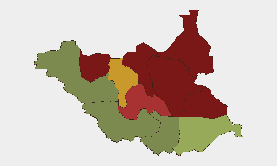
Unity, Jonglei, and Upper Nile states dominate the risk ranking (95, 93, and 88 respectively), driven by active armed conflict, militia presence, and limited government capacity. The 10 August Warrap incursion demonstrates that risk extends into adjacent states ranked lower (Warrap at 72) when Unity-based armed groups conduct cross-border operations. Greater Pibor Administrative Area and Northern Bahr el Ghazal (87 and 82) face similar dynamics rooted in livestock competition and intercommunal tension. Central Equatoria and Western Bahr el Ghazal (35 and 28) remain substantially lower risk, reflecting greater government presence and reduced active conflict intensity.
How GeoBit Would Assist
AOI Monitoring & Early Warning with persistent tracking of high-risk counties (Tonj North, Malakal periphery, Bentiu hinterland) enables duty-of-care teams to receive alerting on emerging incursions and displacement before mass-casualty events mature. Battle Mapping & Force Structure analysis combined with Network & Actor Analysis identifies militia unit movements and recruitment patterns across state lines, supporting advance notice of cross-border raids. Routing & Network Analysis supports security teams planning safer transit corridors and alternative movement timings to avoid checkpoint violence and intercommunal ambush zones. Satellite & Imagery analysis and GIS & Spatial Analysis confirm ground reports of displacement camps and population movements, informing real-time asset and personnel positioning decisions.
7-Day Outlook
Risk of follow-on cattle raids and intercommunal violence in Warrap, Lakes, and Jonglei remains elevated over the next 7 days as armed youth groups exploit the perceived success of the 10 August operations and respond to community retaliation. Checkpoint violence along key transport corridors (Mundri–Juba Road, water-based transit in Jonglei) will likely persist. Government peacekeeping deployments announced for Tonj North may create a temporary security window, but underlying drivers of conflict—competition for pasture and cattle, militia recruitment, and weak state authority—remain unresolved.
Highest-Risk Areas — Ranked
| # | State / Region | Risk |
|---|---|---|
| 1 | Unity | 95 |
| 2 | Jonglei | 93 |
| 3 | Upper Nile | 88 |
| 4 | Greater Pibor Administrative Area | 87 |
| 5 | Northern Bahr el Ghazal | 82 |
| 6 | Lakes | 78 |
| 7 | Warrap | 72 |
| 8 | Ruweng Administrative Area | 68 |
| 9 | Eastern Equatoria | 52 |
| 10 | Western Equatoria | 38 |
| 11 | Central Equatoria | 35 |
| 12 | Western Bahr el Ghazal State | 28 |
Sources
Previous Daily Briefs
A new South Sudan brief is written every day — each with its own risk map and downloadable CSV. Here's the last week; use the calendar to go further back.
📅 Browse every day by calendar →
Highlighted days have a brief. Tap a day for that day's map & analysis, or “csv” for that day's dataset ($5).
Atlas — our AI intelligence desk — emails them this snapshot personally. Nothing else, no list.