Situation Summary
Sudan remains in acute civil war with the conflict now in its second year, characterized by fragmented military control, humanitarian collapse, and escalating drone-strike campaigns particularly in North Kordofan. The country ranks fourth globally for composite threat risk (score 97), driven by active conventional military operations, civilian targeting, and reported chemical weapons allegations that triggered US sanctions on 21 July. Central Darfur State and Al Khartum remain the highest-risk zones, though North Kordofan has emerged as a focal point for recent aerial bombardment and mass displacement. The trajectory remains downward, with no ceasefire negotiations visible and drone strikes intensifying civilian harm.
Key Developments
- Ar Rahad, North Kordofan — 21 July: A drone strike on a civilian market killed at least two children, wounded six children, and caused four adult deaths and over 20 injuries, indicating continued targeting of civilian gathering points.
- North Kordofan (unspecified districts) — 21 July: Rights groups documented drone strikes on civilian vehicles that killed 15 civilians, including five women; vehicles reportedly carried wedding guests and water-transport occupants, suggesting indiscriminate strike patterns.
- El-Obeid vicinity, North Kordofan — 17–21 July: Intensified drone activity and siege-like conditions prompted G7 formal statements urging both sides to halt escalatory actions; multiple strikes reported over the reporting window.
- North Kordofan displacement crisis — 21 July: UN agencies warned that nearly 400,000 internally displaced persons face emergency acute food insecurity amid accelerating violence, exacerbating the humanitarian emergency.
- US sanctions escalation — 21 July: The United States imposed new airspace bans and financing restrictions on Sudan's military-led government, citing alleged chemical weapons use—a significant diplomatic escalation signaling international concern over weapons-of-war claims.
- Khartoum governmental statements — 22 July: Government public statements logged, content unconfirmed at time of brief publication; suggests ongoing diplomatic or military announcements.
Highest-Risk Areas
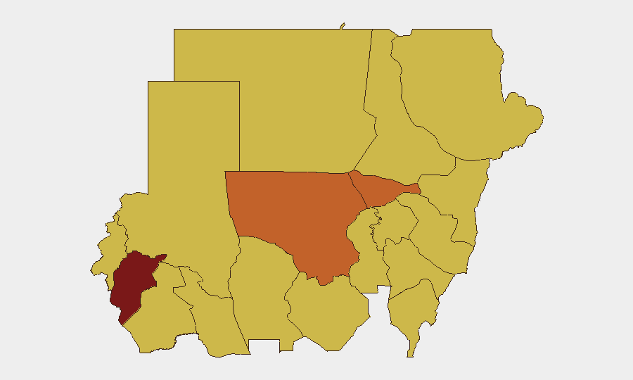
Central Darfur State (97.9) and Al Khartum (74.5) remain the composite-risk apex, reflecting sustained conflict intensity, displacement, and government-control vulnerability. North Kordofan State (74.5) has escalated sharply into the top tier due to the concentrated drone-strike campaign of the past 48 hours; nine additional states (Blue Nile, River Nile, Aj Jazira, Red Sea, Al Qadarif, Kassala, Sennar, South Darfur, West Kordufan) all score 67.9, indicating distributed secondary risk across much of eastern and central Sudan. The pattern reflects a conflict that is neither geographically contained nor rapidly de-escalating.
How GeoBit Would Assist
Security teams managing personnel or assets in Sudan should deploy AOI Monitoring & Early Warning on high-risk districts (especially North Kordofan, Central Darfur, and Khartoum) to receive real-time alerts on drone activity, displacement events, and military operations. Intel Sweep (OSINT fusion across social media, local news, and signal intelligence) provides 24–48-hour event corroboration to validate unconfirmed reports before duty-of-care decisions. Conflict & Military battle mapping and force-structure tracking clarify which armed actors control specific zones, enabling safer routing and asset-relocation planning via Routing & Network Analysis tools.
7-Day Outlook
Drone strikes and ground operations in North Kordofan are expected to persist or intensify absent new ceasefire signals; humanitarian conditions will deteriorate further as displacement accelerates. US and international sanctions may harden positions but are unlikely to produce immediate military de-escalation. Duty-of-care teams should anticipate continued volatility in border zones (South Sudan interface) and assume communications and supply-chain disruptions will worsen.
Highest-Risk Areas — Ranked
| # | State / Region | Risk |
|---|---|---|
| 1 | Central Darfur State | 97.9 |
| 2 | Al Khartum | 74.5 |
| 3 | North Kordofan State | 74.5 |
| 4 | Blue Nile | 67.9 |
| 5 | River Nile State | 67.9 |
| 6 | Aj Jazira | 67.9 |
| 7 | Red Sea State | 67.9 |
| 8 | Al Qadarif State | 67.9 |
| 9 | Kassala State | 67.9 |
| 10 | Sennar State | 67.9 |
| 11 | South Darfur State | 67.9 |
| 12 | West Kurdufan State | 67.9 |
Sources
Previous Daily Briefs
A new Sudan brief is written every day — each with its own risk map and downloadable CSV. Here's the last week; use the calendar to go further back.
📅 Browse every day by calendar →
Highlighted days have a brief. Tap a day for that day's map & analysis, or “csv” for that day's dataset ($5).
Atlas — our AI intelligence desk — emails them this snapshot personally. Nothing else, no list.