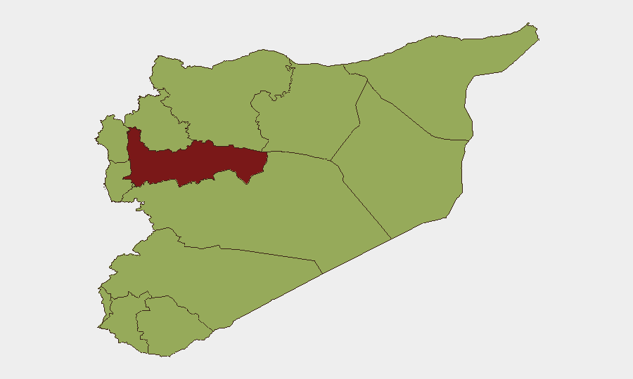
Situation Summary
Syria remains a composite-threat environment (rank #19 globally, score 79) driven primarily by ongoing civil conflict, with 69 tracked events in the current cycle. The capital and key northern provinces continue to experience active security operations, militant activity, and cross-border military pressure. Recent arrests of ISIS-linked cells and tightened security protocols in Damascus suggest authorities are responding to a specific spike in bombing incidents, though underlying fragmentation and sectarian tensions persist across multiple governorates.
Key Developments
- Damascus, 9–10 July: Following bombings on 2 and 7 July, Syrian authorities implemented citywide security escalation—armed patrols, checkpoint expansion, exclusion zones around government/diplomatic facilities, and mandatory vehicle searches now in effect across the capital.
- Damascus, 9–10 July: Interior Ministry announced arrest of ISIS-linked cell responsible for 7 July bombings; officials claimed detainees were members of an Islamic State network apprehended following multi-day investigations.
- Deir Ezzor province (east of Euphrates), 7–8 July: Syrian army repelled SDF-allied militant attack on seven government-held villages; clashes accompanied by US airstrikes; 16 killed reported (11 soldiers, 3 Deir Ezzor Military Council, 2 civilians); situation described as cautious calm by 8 July.
- Al-Quneitra province (Al-Asha village & Saida al-Golan), 9–10 July: Israeli military conducted overnight raid on Al-Asha (15+ vehicles, house and storage facility searched) and established temporary checkpoint in Saida al-Golan; no casualties or arrests reported in either incident.
- Daraa province, early July: Syrian Interior Ministry exposed ISIS-linked criminal financing network; senior ISIS leader arrested; cell financed operations through assassinations and armed robberies targeting gold merchants.
- Suwayda governorate (contact lines), early July: Arabic media reported heightened incidents on southern contact lines including killing of two shepherds by National Guard gunfire and arrest of infiltrator; incidents linked to broader protest waves demanding accountability for pro-Assad figures.
- Iraqi airspace/Syria border, 14 July: Iraqi forces conducted aerial weapons operations against targets in Syria (nature and scope unconfirmed in current reporting).
Highest-Risk Areas
Hama Governorate (risk 85) is the clear epicenter, followed by Damascus (59.6) and Aleppo (59.2). Hama's elevated ranking reflects active conventional military operations and ongoing factional competition; Damascus risk reflects the current bombing cycle and security response; Aleppo combines commercial vulnerability with proximity to Turkish border and residual militant presence. The remaining governorates cluster around risk 55, indicating persistent but more stable baseline threat levels tied to SDF presence (Al-Hasaka, Ar-Raqqa), Israeli activity (Al-Quneitra, Dar'a, UNDOF zone), and sectarian friction.
How GeoBit Would Assist
Security teams with personnel or assets in Syria should prioritize AOI Monitoring & Early Warning on Damascus (current checkpoint/patrol patterns), Hama (military movement tracking), and southern contact lines (Israeli incursions, checkpoint activity). Conflict & Military force-structure analysis paired with OSINT fusion on X/Twitter, regional media, and Telegram would provide near-real-time visibility into ISIS cell activity, arrest announcements, and cross-border operations. GIS & Spatial Analysis combined with alternative routing tools enables duty-of-care teams to map safe corridors around active security zones and re-established checkpoints.
7-Day Outlook
Damascus is likely to maintain elevated security posture for at least one week; additional arrests or disclosure of new ISIS cells are probable as authorities consolidate recent operations. Cross-border pressure (Israeli, Iraqi, US-backed SDF) on peripheral provinces will persist at current tempo. Risk of secondary bombing incidents in Damascus or coordinated militant activity in Aleppo/Hama remains elevated but will likely diminish if arrest announcements continue.
Highest-Risk Areas — Ranked
| # | State / Region | Risk |
|---|---|---|
| 1 | Hama Governorate | 85 |
| 2 | Damascus Governorate | 59.6 |
| 3 | Aleppo Governorate | 59.2 |
| 4 | Al-Hasaka Governorate | 55.3 |
| 5 | Lattakia Governorate | 55 |
| 6 | Tartus Governorate | 55 |
| 7 | UNDOF | 55 |
| 8 | Al-Quneitra Governorate | 55 |
| 9 | Dar'a Governorate | 55 |
| 10 | Idleb Governorate | 55 |
| 11 | Ar-Raqqa Governorate | 55 |
| 12 | Homs Governorate | 55 |
Sources
Previous Daily Briefs
A new Syria brief is written every day — each with its own risk map and downloadable CSV. Here's the last week; use the calendar to go further back.
📅 Browse every day by calendar →
Highlighted days have a brief. Tap a day for that day's map & analysis, or “csv” for that day's dataset ($5).
Atlas — our AI intelligence desk — emails them this snapshot personally. Nothing else, no list.