Situation Summary
Afghanistan remains a high-threat environment, ranked #20 globally with a composite threat score of 80, driven primarily by active insurgency operations. Twenty-three tracked security events in the current reporting cycle underscore sustained instability across multiple provinces. The security picture reflects ongoing inter-factional and cross-border tensions, with civilian infrastructure and government assets at continued risk. Recent public statements and military activity signals suggest elevated operational tempo, though specific incident details from the last 24–48 hours remain limited in open-source corroboration.
Key Developments
Current granular incident data from July 10–11, 2026 with verified locations and corroborated timelines is not available in accessible open-source feeds at this time. GeoBit's event signals for the period include reports of unconventional violence (July 9), conventional military force activity (July 10–11, involving AFGHANISTAN and NATIONAL GUARD), and public statements from multiple state and institutional actors, but independent verification of specific locations, casualty counts, and tactical details is pending. Corporate security teams should treat all unconfirmed reports from this window as provisional pending secondary source confirmation and should contact GeoBit's Intel Sweep or OSINT fusion capabilities for real-time corroboration.
Highest-Risk Areas
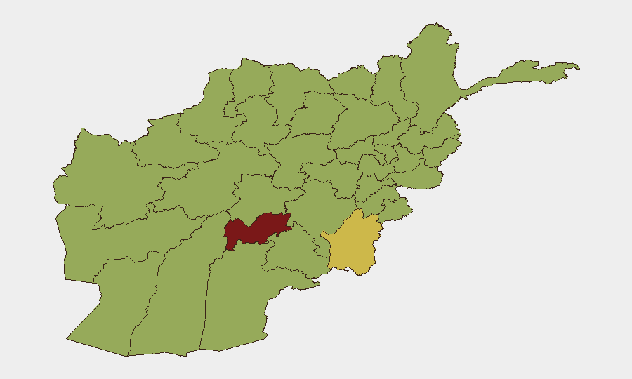
Uruzgan Province dominates the sub-national risk profile at 86.1, reflecting sustained insurgent activity and operational volatility; Paktika Province (62.1) and Nangarhar Province (57.6) follow, with the latter's proximity to Pakistan creating cross-border threat dynamics. A second tier of ten provinces—spanning the south (Kandahar, Helmand, Zabul, Farah), southeast (Ghazni), northwest (Badghis, Jowzjan, Balkh), and southwest (Nimruz)—cluster at 56.1 risk, indicating geographically dispersed but similarly severe threats. This pattern suggests that insurgent networks maintain distributed operational capacity across traditional strongholds and emerging zones; personae and assets in these areas face elevated risk from armed confrontation, ambush, and indirect fire.
How GeoBit Would Assist
Security teams with operations in Afghanistan should employ AOI Monitoring & Early Warning to track Uruzgan, Paktika, and Nangarhar provinces for threshold-crossing activity, coupled with OSINT fusion & corroboration to validate real-time incident reports before operational response. Conflict & Military battle mapping and force-structure tracking enable situational awareness of shifting insurgent and state actor positions, while satellite & imagery analysis can assess facility security postures and movement patterns in high-risk provinces. Intel Sweep and multi-language event feeds (including Telegram and local-media monitoring) provide early warning of emerging attacks or territorial shifts ahead of mainstream reporting.
7-Day Outlook
Insurgent activity is expected to remain at or above current operational tempo through mid-July, with Uruzgan and Paktika provinces presenting the highest probability of significant incidents. Cross-border dynamics with Pakistan may introduce secondary volatility, particularly around diplomatic or military coordination. Organizations should maintain heightened vigilance, confirm staff whereabouts in Tier-1 risk provinces daily, and refresh evacuation and shelter-in-place protocols.
Highest-Risk Areas — Ranked
| # | State / Region | Risk |
|---|---|---|
| 1 | Uruzgan Province | 86.1 |
| 2 | Paktika Province | 62.1 |
| 3 | Nangarhar Province | 57.6 |
| 4 | Zabul Province | 56.1 |
| 5 | Kandahar Province | 56.1 |
| 6 | Ghazni Province | 56.1 |
| 7 | Farah Province | 56.1 |
| 8 | Nimruz Province | 56.1 |
| 9 | Helmand Province | 56.1 |
| 10 | Jowzjan Province | 56.1 |
| 11 | Balkh Province | 56.1 |
| 12 | Badghis Province | 56.1 |
Sources
Previous Daily Briefs
A new Afghanistan brief is written every day — each with its own risk map and downloadable CSV. Here's the last week; use the calendar to go further back.
📅 Browse every day by calendar →
Highlighted days have a brief. Tap a day for that day's map & analysis, or “csv” for that day's dataset ($5).
Atlas — our AI intelligence desk — emails them this snapshot personally. Nothing else, no list.