Situation Summary
Angola remains at moderate global risk (#53 globally; composite threat score 32) with no tracked security events in the last 24–48 hours, but continues to experience significant sub-national instability concentrated in resource-rich eastern and northeastern provinces. The most consequential recent development is the targeted cyberattack against Unitel (28–29 July), which disrupted nationwide telecommunications for over 21 million subscribers and occurred immediately before the carrier's planned stock listing; services remain partially affected. Beyond that incident, baseline conditions reflect routine urban criminality and environmental hazards (active wildfires across multiple provinces), with national infrastructure (power, fuel, airports, ports) operating normally.
Key Developments
- Luanda (nationwide Unitel network) – 28–29 July 2026
Targeted cyberattack on Unitel's infrastructure disrupted voice, mobile data, and internet services nationwide at ~02:20 local time on 28 July; partial service disruptions persisted into 29 July. Incident affected 21+ million subscribers and occurred one day before Unitel's planned exchange listing. No threat actor has claimed responsibility; monitoring platforms suggest possible APT involvement, but attribution remains unconfirmed.
- Multiple provinces – ongoing, late July 2026
Active wildfire events tracked across Angola (Lunda Norte, Lunda Sul, Moxico, Huambo, and other provinces). Environmental hazard affecting visibility, air quality, and localized economic activity; no reported mass displacement or emergency services collapse.
- Countrywide – 27–28 July 2026 (baseline)
No confirmed major security incidents, armed clashes, terrorist attacks, mass protests, or critical infrastructure failures reported during this window. Routine urban criminality and minor service disruptions remain within normal parameters.
Highest-Risk Areas
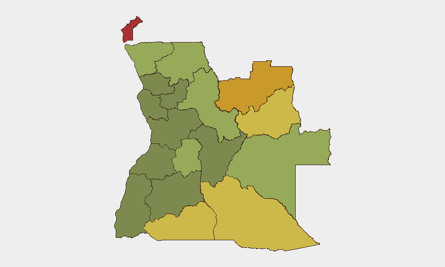
Eastern and northeastern provinces—Cabinda (risk 78), Lunda Norte (72), Lunda Sul (68), and Cuando Cubango (64)—account for the highest composite threat scores, driven by ongoing competition for resource extraction (diamonds, oil), weak state capacity, armed group activity (UNITA legacy networks, splinter elements), and cross-border criminal networks. Cabinda Province remains Angola's single highest-risk jurisdiction, reflecting decades of separatist insurgency and persistent militia presence. Cunene, Moxico, and Zaire provinces (risk 58–62) present secondary risk clusters, primarily linked to cross-border smuggling, informal mining, and intermittent armed incursions; western and central provinces (Luanda, Benguela, Huíla) show substantially lower risk profiles.
How GeoBit Would Assist
Security and duty-of-care teams operating in Angola should deploy AOI (Area-of-Interest) Monitoring & Early Warning on Cabinda, Lunda Norte/Sul, and Cuando Cubango to detect emerging incidents (armed activity, mass movement, checkpoints) before they affect supply chains or personnel. Network & Actor Analysis combined with OSINT fusion (X/Twitter, Telegram, open-source conflict feeds) provides near-real-time visibility into splinter UNITA movements, militia posturing, and informal mining incursions that precede violence. Routing & Network Analysis enables alternative journey planning for personnel transiting high-risk provinces, while GIS & Spatial Analysis of wildfire hotspots and cyberattack impact zones informs evacuation and contingency protocols.
7-Day Outlook
The Unitel cyberattack impact is expected to stabilize within 48–72 hours as full service restoration proceeds; no secondary incidents or copycat attacks have been flagged. Sub-national risk in the eastern provinces will likely remain elevated but stable, with routine criminal and militia activity continuing at baseline. Wildfire season will persist; personnel and supply-chain managers should prepare for localized air-quality degradation and temporary route disruptions.
Highest-Risk Areas — Ranked
| # | State / Region | Risk |
|---|---|---|
| 1 | Cabinda Province | 78 |
| 2 | Lunda Norte Province | 72 |
| 3 | Lunda Sul Province | 68 |
| 4 | Cuando Cubango Province | 64 |
| 5 | Cunene Province | 62 |
| 6 | Moxico Province | 58 |
| 7 | Zaire Province | 54 |
| 8 | Huambo Province | 50 |
| 9 | Uíge Province | 48 |
| 10 | Malanje Province | 42 |
| 11 | Bié Province | 35 |
| 12 | Huíla Province | 32 |
Sources
Previous Daily Briefs
A new Angola brief is written every day — each with its own risk map and downloadable CSV. Here's the last week; use the calendar to go further back.
📅 Browse every day by calendar →
Highlighted days have a brief. Tap a day for that day's map & analysis, or “csv” for that day's dataset ($5).
Atlas — our AI intelligence desk — emails them this snapshot personally. Nothing else, no list.