Situation Summary
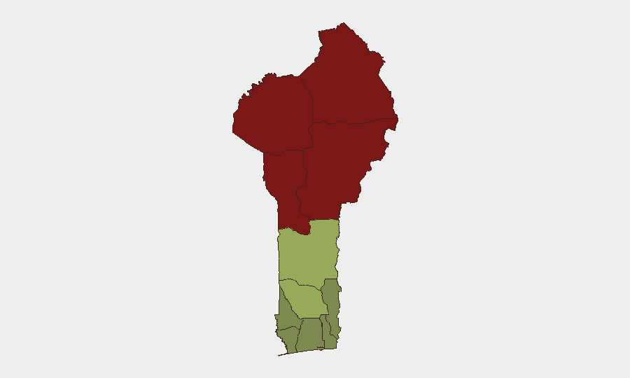
Benin remains at moderate overall risk (global rank #48, composite score 37), with terrorism and insurgency as the primary threat drivers, though no tracked incidents have been recorded. The security picture is dominated by northern regional instability—particularly in Alibori, Atakora, Donga, and Borgou departments—linked to spillover from Niger and Nigeria's armed group activity, compounded by cross-border criminal activity and drug trafficking. Southern and coastal departments retain significantly lower risk profiles. As of 1 September 2026, no major security incidents within Benin have been confirmed in the last 24–48 hours; the most recent documented events date to 26–27 August.
Key Developments
- 26 August, Godomey (Atlantique Department): A police sub-inspector was fatally struck by a vehicle during a pursuit following a robbery incident; one suspect arrested, one sought. This incident highlights vulnerability of law-enforcement personnel in routine crime interventions.
- 27 August, Savè/Atta (Okpara district, Zou Department): Republican Police dismantled a large-scale cannabis cultivation operation, seizing over 30 kg and discovering a plantation exceeding one hectare. The operation reflects ongoing anti-drug enforcement in agriculturally productive zones.
- 26 August, Alibori & Atakora border zones: Approximately 2,000 Nigerian civilians crossed into Benin following mass kidnapping incidents in Nigeria's Niger State (Borgu area). Cross-border population movements of this scale suggest acute displacement pressure and potential strain on Benin's border management and humanitarian services.
- Recent (late August): Presidential pardons issued 1 August continue to generate security concerns; at least one pardoned individual was detained 21–22 August during an attempted motorcycle theft, signaling re-offending risk among released cohorts.
- Recent (late August): Armed robberies targeting motorcycle-taxi operators and personal vehicles reported in Pahou (near Vassého) and other locales, indicating organized or opportunistic small-unit crime activity against vulnerable transport users.
*Note:* No confirmed, incident-level security events inside Benin dated 31 August or 1 September 2026 are available from current open-source reporting. The above reflects the most recent documented incidents (26–27 August); regional context from Nigeria's ongoing Borgu area violence significantly affects Benin's northern border threat environment, though those incidents are located in Nigeria.
Highest-Risk Areas
The four northernmost departments—Alibori (risk 92), Atakora (88), Donga (85), and Borgou (83)—account for the overwhelming majority of Benin's composite threat score, driven by proximity to active insurgent and criminal networks in Niger and Nigeria, porous borders, and limited state presence. Zou Department (risk 45) represents a secondary risk tier, likely reflecting both geographic proximity to the north and drug-trafficking corridor activity. All remaining southern and coastal departments score below 45, reflecting stronger state control, urban density, and lower militant/terrorist presence. Organizations with personnel or assets in the north should assume elevated exposure to armed-group activity, kidnapping, and banditry; southern operations face primarily common crime and corruption risks.
How GeoBit Would Assist
A corporate security team in Benin would deploy AOI Monitoring & Early Warning on high-risk northern departments to detect emerging armed-group activity, displacement, or cross-border movements in near-real time. Satellite & Imagery analysis and GIS & Spatial Analysis enable tracking of militant camps, supply routes, and population shifts. Intel Sweep and multi-language OSINT fusion (radio SIGINT, social-media monitoring) provide early signals of kidnapping campaigns or criminal recruitment before they affect specific business locations.
7-Day Outlook
Northern Benin is likely to remain under chronic low-level pressure from cross-border spillover, with intermittent armed-group probing and banditry rather than coordinated large-scale attacks. Cross-border displacement from Nigeria may continue if Borgu-area violence persists, affecting humanitarian and security resources in Alibori and Atakora. Southern departments should remain stable, though petty crime and road-incident risks will persist across all regions.
Highest-Risk Areas — Ranked
| # | State / Region | Risk |
|---|---|---|
| 1 | Alibori Department | 92 |
| 2 | Atakora Department | 88 |
| 3 | Donga Department | 85 |
| 4 | Borgou Department | 83 |
| 5 | Zou Department | 45 |
| 6 | Collines Department | 42 |
| 7 | Plateau Department | 38 |
| 8 | Kouffo Department | 35 |
| 9 | Mono Department | 32 |
| 10 | Atlantique Department | 28 |
| 11 | Littoral | 25 |
| 12 | Ouémé Department | 22 |
Sources
Previous Daily Briefs
A new Benin brief is written every day — each with its own risk map and downloadable CSV. Here's the last week; use the calendar to go further back.
- August 30, 2026
- August 28, 2026
- August 26, 2026
- August 24, 2026
- August 22, 2026
- August 20, 2026
- August 18, 2026
📅 Browse every day by calendar →
Highlighted days have a brief. Tap a day for that day's map & analysis, or “csv” for that day's dataset ($5).
Atlas — our AI intelligence desk — emails them this snapshot personally. Nothing else, no list.