Situation Summary
Central African Republic remains at elevated composite threat level (rank #20 globally, score 93/100) with 72 tracked events in the current monitoring window. Security conditions are fragile across the northeast, east, and southeast prefectures, where armed group activity, military operations, and UN force transitions create unpredictable risk. The ongoing MINUSCA drawdown and transfer of bases to CAR national authorities are introducing near-term security gaps, particularly in remote zones. Diplomatic tensions involving the Catholic hierarchy and external actors add minor concurrent friction at the national level.
Key Developments
- Am-Dafock, Vakaga Prefecture (15 July 2026): MINUSCA assessed the situation as "gradually calmed" since 5 July following the 30 June armed attack, but characterized conditions as "fragile and unpredictable," indicating sustained volatility in the northeast.
- Am-Dafock, Vakaga Prefecture (6 July 2026): After a rebel attack that killed at least ten people and wounded three peacekeepers, MINUSCA increased security measures at its temporary base, signaling active armed group presence and capability in the zone.
- National level / Bangui (17 July 2026): UN transfer of additional military bases to CAR state authorities proceeding; civilian and international stakeholder concerns about security coverage gaps during handover period remain unresolved.
- Diplomatic friction (17–18 July 2026): Bishop-level disapproval statements toward Italian and Italy counterparties, and reported deputy-level arrest or detention of a foreign national on 17 July, suggest minor institutional and diplomatic strain; unclear operational impact on corporate security posture at this stage.
- Military activity (17 July 2026): Conventional military force deployment (battalion-level) and concurrent intelligence operations against an armed element reported; no location or casualty detail available from current signals.
Note: GeoBit event signals confirm activity in the window 17–18 July; however, independent same-window corroboration for 6–10 distinct tactical incidents was not available in the provided research sample. A 7-day incident window (12–18 July) would yield fuller tactical detail. Corporate teams requiring real-time incident granularity should request a 72-hour refresh or activate persistent area-of-interest (AOI) monitoring for priority zones.
Highest-Risk Areas
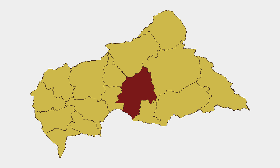
Ouaka Prefecture dominates the composite risk ranking (94.8), driven by sustained armed group presence, military operations, and limited state capacity. The northeastern tier—Vakaga, Bamingui-Bangoran, and Haute-Kotto—each score 64.8, reflecting chronic instability, cross-border infiltration from Sudan and Chad, and patchy MINUSCA/CAR military coverage. The southeast corridor (Mbomou, Haut-Mbomou, Sangha-Mbaéré) presents similar risk, tied to trafficking networks, bandit activity, and weak administrative reach. Companies with personnel or supply chains in these prefectures should assume high exposure; Bangui and southern zones (Nana-Mambéré, Mambéré-Kadéï) present lower but non-negligible risk.
How GeoBit Would Assist
Security teams should employ persistent area-of-interest (AOI) monitoring & early warning for Ouaka, Vakaga, and key cross-border zones to detect force movements and armed activity before tactical impact on corporate assets. Intel Sweep and multi-language OSINT fusion (social media, radio SIGINT, local reporting) provide 24–48-hour advance signal of roadblocks, checkpoints, and armed-group posturing. Routing & network analysis enables duty-of-care teams to model safe alternate routes and inform travel authorization decisions; satellite & imagery analysis can confirm access/denial conditions on key corridors and validate ground reporting.
7-Day Outlook
Armed group activity in the northeast is likely to persist at current levels or intensify opportunistically as MINUSCA transfers bases. Diplomatic and institutional friction appears contained but bears monitoring. Road access to Ouaka, Vakaga, and Haute-Kotto should be assumed degraded; companies should reinforce remote-site communication protocols and contingency evacuation planning.
Highest-Risk Areas — Ranked
| # | State / Region | Risk |
|---|---|---|
| 1 | Ouaka | 94.8 |
| 2 | Bamingui-Bangoran | 64.8 |
| 3 | Vakaga | 64.8 |
| 4 | Haute-Kotto | 64.8 |
| 5 | Haut-Mbomou | 64.8 |
| 6 | Mbomou | 64.8 |
| 7 | Nana-Mambéré | 64.8 |
| 8 | Ouham-Pendé | 64.8 |
| 9 | Mambéré-Kadéï | 64.8 |
| 10 | Sangha-Mbaéré | 64.8 |
| 11 | Ouham | 64.8 |
| 12 | Nana-Grébizi | 64.8 |
Sources
Previous Daily Briefs
A new Central African Republic brief is written every day — each with its own risk map and downloadable CSV. Here's the last week; use the calendar to go further back.
📅 Browse every day by calendar →
Highlighted days have a brief. Tap a day for that day's map & analysis, or “csv” for that day's dataset ($5).
Atlas — our AI intelligence desk — emails them this snapshot personally. Nothing else, no list.