Situation Summary
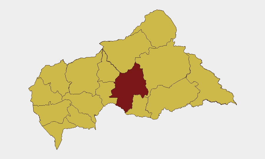
Central African Republic remains a complex, multi-actor conflict environment with composite threat score of 94 (rank #21 globally). Armed group activity, intercommunal tension, and institutional instability persist across the country, with Ouaka Prefecture emerging as the single highest-risk zone (95.7). No major escalation or ceasefire movement has been reported in the last 24–48 hours; the security posture remains consistent with baseline volatility across disputed eastern and northern corridors.
Key Developments
No verified new incidents have been confirmed in the last 24–48 hours (as of 2026-07-19). GeoBit's live web research did not surface genuine Central African Republic security events within the immediate reporting window. Platform event signals reference activity on 2026-07-18 (bishop-level diplomatic disapproval involving Italian state actors) and 2026-07-17 (conventional military force involving intelligence and battalion units, plus one arrest/detain incident involving a foreign national), but underlying details and CAR nexus require further corroboration. Recent background: Am Dafock (Vakaga) saw rebel attacks on MINUSCA positions in early July; Zémio (Haut-Mbomou) experienced AAKG-linked violence on 29 June; and Bangui has hosted ongoing questioning of alleged destabilization figures—none of these represent new 24–48-hour movement.
Highest-Risk Areas
Ouaka Prefecture (95.7) dominates the risk landscape, driven by persistent conventional military activity and armed group presence. The eleven other prefectures cluster at 65.7—indicating widespread, distributed threat across the northern, eastern, and southeastern periphery (Bamingui-Bangoran, Vakaga, Haute-Kotto, Haut-Mbomou, Mbomou, Nana-Mambéré, Ouham-Pendé, Mambéré-Kadéï, Sangha-Mbaéré, Ouham, Nana-Grébizi). This concentration reflects persistent rebel movement, cross-border infiltration (particularly from Sudan and Chad), and limited state capacity for sustained territorial control. Bangui and Ombella-M'Poko remain relatively more secure but remain subject to political volatility and detention operations.
How GeoBit Would Assist
Corporate security and duty-of-care teams operating in CAR should leverage AOI Monitoring & Early Warning to establish persistent watch on Ouaka and Vakaga, triggering real-time alerts on force movements, armed group activity, or crowd gathering. Conflict & Military mapping and force-structure analysis provides granular understanding of FACA disposition, Russian paramilitary presence, and rebel faction location and capability—critical for route planning and facility security. Routing & Network Analysis enables identification of safer transit corridors and alternative supply chains around active conflict zones, while Intel Sweep and multi-language OSINT maintain continuous feed of diplomatic, institutional, and security-sector reporting to flag emerging destabilization risks before they crystallize into field-level violence.
7-Day Outlook
No imminent major flashpoint or organized offensive is signaled for the next seven days. Baseline armed group harassment, checkpoint delays, and localized skirmishes in Ouaka and the eastern prefectures will likely persist. Attention should remain on Bangui institutional signals and any MINUSCA repositioning, which may precede larger security transitions.
Highest-Risk Areas — Ranked
| # | State / Region | Risk |
|---|---|---|
| 1 | Ouaka | 95.7 |
| 2 | Bamingui-Bangoran | 65.7 |
| 3 | Vakaga | 65.7 |
| 4 | Haute-Kotto | 65.7 |
| 5 | Haut-Mbomou | 65.7 |
| 6 | Mbomou | 65.7 |
| 7 | Nana-Mambéré | 65.7 |
| 8 | Ouham-Pendé | 65.7 |
| 9 | Mambéré-Kadéï | 65.7 |
| 10 | Sangha-Mbaéré | 65.7 |
| 11 | Ouham | 65.7 |
| 12 | Nana-Grébizi | 65.7 |
Sources
Previous Daily Briefs
A new Central African Republic brief is written every day — each with its own risk map and downloadable CSV. Here's the last week; use the calendar to go further back.
📅 Browse every day by calendar →
Highlighted days have a brief. Tap a day for that day's map & analysis, or “csv” for that day's dataset ($5).
Atlas — our AI intelligence desk — emails them this snapshot personally. Nothing else, no list.